|
Biodiversity Data Journal :
Data paper
|
The distribution of the vascular plants on the North Frisian Island, Amrum
|
Corresponding author:
Academic editor: Daniele Cicuzza
Received: 30 Apr 2014 | Accepted: 02 Jun 2014 | Published: 10 Jun 2014
© 2014 Quentin Groom
This is an open access article distributed under the terms of the Creative Commons Attribution License (CC BY 4.0), which permits unrestricted use, distribution, and reproduction in any medium, provided the original author and source are credited.
Citation:
Groom Q (2014) The distribution of the vascular plants on the North Frisian Island, Amrum. Biodiversity Data Journal 2: e1108. https://doi.org/10.3897/BDJ.2.e1108
|
|
Abstract
Amrum is a small barrier island on the north-west coast of Germany. The distribution of vascular plants was examined by surveying their 1km2 grid square occupancy across the whole island. These data were used in a study on the recent vegetation change in the island. These data include 3786 observations of 450 taxa collected in two surveys in 2007 and 2008.
Keywords
Amrum, vascular plants, plant survey
Introduction
Amrum is a small barrier island off the coast of Schleswig-Holstein, Germany. It covers an area of about 20 km2, though considerable areas of saltmarsh vegetation are exposed at low tide. Amrum has been the subject of many botanical surveys and this survey continues that tradition (
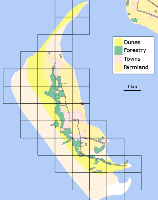
Amrum is approximately 10 km long and 3 km wide at its widest point (Fig.
These data were used in a study of change in the islands flora (
Sampling methods
The survey covered all vegetated areas of the island were access was permitted. In fact, this covers most of the island, however, some nesting bird colonies and private gardens are completely inaccessible.
The biodiversity of each 1 km2 varies considerable so there was no set time limit for surveying a particular square. Grid squares were surveyed as intensively as considered necessary to find all but the rarest species. Aerial photographs, maps, previous surveys and local experts were all used to direct surveying to all potentially important habitats. The grid is based upon the spatial reference system EPSG:31467 - DHDN / Gauss-Kruger zone 3 (Fig.
Some Salix specimens where identified by R.D. Meikle.
Geographic coverage
Amrum is one of the North Frisian Islands, Schleswig-Holstein, Germany. Its western coast faces the North Sea and the eastern coast faces the Wadden Sea (Fig.
54° 36' 22.9602" and 54° 42' 44.1936" Latitude; 8° 17' 26.5308" and 8° 24' 12.6138" Longitude.
Taxonomic coverage
The study covers all vascular plants growing in the wild. Obviously cultivated plants were excluded, though trees planted for forestry were included as these form so much of the island's habitats. Some examples of natural habitats on Amrum are illustrated (Fig.
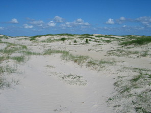
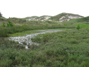
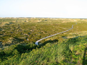
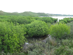
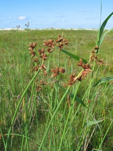
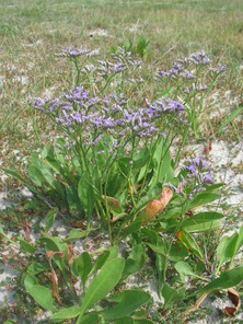
Examples of some of the habitats and plants found on Amrum.
b: A mature wet dune slack, habitat to Erica tetralix and Eriophorum angustifolium.
c: Calluna vulgaris heath on stabilized dunes, taken from the lighthouse called the Quermarkenfeuer (54°40'9.25"N, 8°18'30.84"E).
d: Salix cinerea carr at the western end of the Nehrungssee (54°37'22.77"N, 8°22'0.42"E).
e: Bolboschoenus maritimus
f: Limonium vulgare
Temporal coverage
Usage rights
Data resources
| Column label | Column description |
|---|---|
| genus | The genera of the taxon. |
| specificEpithet | The specific epithet of the taxon. |
| taxonRank | The taxonomic rank of the name. |
| infraspecificEpithet | The infraspecific name of the taxon, if identified to this rank. |
| scientificName | full scientific names, written out as a string with authority. |
| kingdom | The taxonomic kingdom to which the organism belongs. |
| family | The taxonomic family to which the organism belongs. |
| vernacularName | The English common name of the taxon. |
| nomenclaturalCode | International Code of Nomenclature for the name. |
| identifiedBy | The identifier of the specimen. |
| recordedBy | The person who found the specimen. |
| language | The language used in the observation details. |
| rights | The rights given to the use of these data. |
| rightsHolder | The person to whom these right belong. |
| datasetID | A unique identifier to this dataset. |
| datasetName | The name of this dataset. |
| basisOfRecord | How the observation was made. |
| occurrenceStatus | An indication of the about the presence or absence of a taxon at a location. |
| individualCount | The number of individuals observed. If left blank the taxon was observed, but not counted. |
| eventDate | The date on which the observation occurred. |
| month | The month in which the observation occurred. |
| year | The year in which the observation occurred. |
| occurrenceRemarks | Additional notes on the observation. |
| establishmentMeans | How the taxon became established at the location. Frequently used where the taxon was planted. |
| occurrenceID | A unique identifier to the observation. |
| locality | A textual description of the precise locality. |
| higherGeography | A textual description of the region in which the observation occurred. |
| islandGroup | The name of the island group in which the observation occurred. |
| island | The name of the island in which the observation occurred. |
| country | The name of the country in which the observation occurred. |
| countryCode | The ISO 3166-1-alpha-2 country code. |
| stateProvince | The first-level administrative subdivision of the country in which the observation occurred. |
| continent | The continent in which the observation occurred. |
| verbatimCoordinates | The geographic coordinates of the observation written out. |
| verbatimSRS | The spatial reference system of the verbatim coordinates. |
| footprintWKT | A Well-Known Text (WKT) representation of the shape that defines the location. |
| footprintSRS | The spatial reference system of the footprint WKT coordinates. |
| habitat | A textual description of the habitat in which the taxon was observed. |
| coordinateUncertaintyInMeters | The limit of the distance (in meters) from the given coordinates describing a circle within which the locality must lie. |
| decimalLongitude | The longitude of the location the observation was made, in decimal degrees. |
| decimalLatitude | The latitude of the location the observation was made, in decimal degrees. |
| geodeticDatum | The geodetic datum to which the latitude and longitude refer. |
| pointRadiusSpatialFit | The ratio of the area of the point-radius to the actual area of the spatial representation of the location |
References
- Flora der Nordfriesischen Inseln.Cram, de Gruyter & Co.,Hamburg,127pp. [InGerman].
- A comparison of species lists of vascular plants points to recent habitat change on the North Frisian Island, Amrum.Schriften des Naturwissenschaftlichen Vereins für Schleswig-Holstein72:29‑35. [InEnglish]. URL: http://www.schriften.uni-kiel.de/Band%2072/Groom.pdf
- Die dünentalvegetation der wattenmeer- inseln in der südlichen Nordsee.Husum Druck- und Verlagsgesellschaft,Husum,205pp. [InGerman]. [ISBN9783880429352]
- Beretning om en botanisk Reise, foretaget i Sommeren 1858 i Landskabebet mellem Sleswig, Rendsborg og Ekernførde samt paa Vesterhavsøerne Amrom, Før og Sild.Videnskab. Meddel.-:117‑168. [InDanish].
- Flora und Vegetation der Insel Amrum – Bestand, Wandel, Gefährdung.Schriften des Naturwissenschaftlichen Vereins für Schleswig-Holstein64:17‑89. [InGerman]. URL: http://www.schriften.uni-kiel.de/Band%2064/Tuerk_64_17-89.pdf
- Einige Mitteilungen über die in dem Herbar K. F. W. Jessen enthaltenen Pflanzen von der Nordfriesischen Insel Amrum.Botanische Jahrbücher für Systematik, Pflanzengeschichte und Pflanzengeographie27(62):6‑7. [InGerman]. URL: http://biodiversitylibrary.org/page/210409
Supplementary material
A Darwin Core Archive of vascular plant occurrences from the island of Amrum, Germany recorded in 2007 and 2008