|
Biodiversity Data Journal :
Data paper
|
MidMedPol: Polychaetes from midlittoral rocky shores in Greece and Italy (Mediterranean Sea)
|
Corresponding author:
Academic editor: Pavel Stoev
Received: 26 Jul 2013 | Accepted: 09 Sep 2013 | Published: 16 Sep 2013
© 2013 Kleoniki Keklikoglou, Sarah Faulwetter, Georgios Chatzigeorgiou, Fabio Badalamenti, Militiadis Kitsos, Christos Arvanitidis
This is an open access article distributed under the terms of the Creative Commons Attribution License (CC BY 3.0), which permits unrestricted use, distribution, and reproduction in any medium, provided the original author and source are credited.
Citation:
Keklikoglou K, Faulwetter S, Chatzigeorgiou G, Badalamenti F, Kitsos M, Arvanitidis C (2013) MidMedPol: Polychaetes from midlittoral rocky shores in Greece and Italy (Mediterranean Sea). Biodiversity Data Journal 1: e961. https://doi.org/10.3897/BDJ.1.e961
|
|
Abstract
This paper describes a dataset of polychaetes (Annelida) from 14 midlittoral rocky shore sampling sites in Greece and Italy (Mediterranean Sea). The dataset combines the outcome of four different projects studying the hard substrate midlittoral zone in the Mediterranean between 1984 and 2009. Samples were collected by scraping and collecting the organisms from a framed area. The maximal sampling depth was 1.5 m. In total, 123 polychaete species were recorded, five of which are new records for the respective biogeographic sectors of the Mediterranean. The dataset contains 788 occurrence records, fully annotated with all required metadata. These data contribute to the knowledge of a previously very understudied regional habitat, since at present, comprehensive lists of the midlittoral communities in the Mediterranean are provided through only a few, paper-based, studies. This dataset is one of the first electronic data compilations of the Mediterranean midlittoral zone communities and certainly the most comprehensive of its kind, contributing to the ongoing efforts of the Ocean Biogeographic Information System (OBIS) which aims at filling the gaps in our current knowledge of the world's oceans. It is accessible at http://ipt.vliz.be/resource.do?r=mediterraneanpolychaetaintertidal.
Keywords
Midlittoral zone, Polychaeta, rocky shores, Mediterranean Sea, biodiversity, intertidal, Italy, Greece, 1984–2009
Introduction
The Mediterranean Sea is an enclosed water basin with a very low tidal range, in the range of 20–40 cm (
Despite the ecological importance and easy accessibility from the shore, only few studies have examined the species communities of the Mediterranean midlittoral zone (e.g.
This study attempts to increase our current knowledge of the rocky midlittoral zone of Mediterranean Sea by providing species occurrence data of polychaete species, assembled from four independent and previously unpublished datasets. Polychaetes are often used as a representative group of macrobenthic communities because they tend to be the dominant taxon in these communities and hence, they are used as indicators of environmental disturbance (e.g.
| Country | Sampling Site | Latitude | Longitude | Minimum depth (in meters) | Maximum depth (in meters) | Sampling period |
| Greece | Alykes | 35.41461 | 24.98816 | 0 | 0.5 | 09/2007 and 06/2008 |
| Greece | Elounda | 35.26125 | 25.75178 | 0 | 0.5 | 09/2007 and 05/2009 |
| Greece | Evripos channel (St. 1a) | 38.46432 | 23.5917 | 0 | 0.2 | 09/1997-10/1997 |
| Greece | Evripos channel (St. 1b) | 38.46342 | 23.59038 | 0 | 0.2 | 09/1997-10/1997 |
| Greece | Evripos channel (St. 1c) | 38.46302 | 23.58922 | 0 | 0.2 | 09/1997-10/1997 |
| Greece | Thermaikos Gulf (St.2a) | 40.46238 | 22.85345 | 0 | 0.2 | 09/1997-10/1997 |
| Greece | Thermaikos Gulf (St.2b) | 40.50664 | 22.9078 | 0 | 0.2 | 09/1997-10/1997 |
| Greece | Thermaikos Gulf (St.2c) | 40.59685 | 22.94731 | 0 | 0.2 | 09/1997-10/1997 |
| Greece | Nea Roda | 40.38238 | 23.93882 | 0 | 1.5 | 09/1997-10/1997 |
| Greece | Porto Karas | 40.07488 | 23.79555 | 0 | 0.3 | 09/1997-10/1997 |
| Greece | Porto Lagos | 41.00581 | 25.11961 | 0 | 0.2 | 09/1997-10/1997 |
| Italy | Balestrate | 38.05072 | 12.99988 | 0 | 0.3 | 1989 (spring, summer, autumn, winter) |
| Italy | Zingaro | 38.09721 | 12.8027 | 0 | 0.3 | 1984 (spring) |
| Italy | Capo Gallo | 38.21174 | 13.28836 | 0 | 0.3 | 1986 (spring, autumn, winter) |
Project description
This dataset combines the data of four independent sampling campaigns: (a) the monitoring of midlittoral rocky shores in Crete in the framework of the NaGISA project (Natural Geography in Shore Areas, http://www.coml.org/projects/natural-geography-shore-areas-nagisa); (b) the study of the biodiversity of midlittoral rocky shores in the framework of the PhD thesis of Militadis-Spyridonas Kitsos (Aristotelian University of Thessaloniki); (c) the preliminary study to establish marine protected areas in Sicily (Capo Gallo and Zingaro, north-western coast of Sicily, Italy) and (d) a monitoring project to assess the effects of a temporal explosion of Sabellaria spp. and Mytilaster spp. (Balestrate, north-western coast of Sicily, Italy).
Christos Arvanitidis, HCMR (project coordinator, sample collection), Georgios Chatzigeorgiou, HCMR (sample collection, sample identification), Sarah Faulwetter, HCMR (sample collection, sample identification, data management), Kleoniki Keklikoglou, HCMR/University of Crete (sample identification, data management), Fabio Badalamenti, CRN-IAMC, Italy (sample collection, sample identification), Militadis-Spyridonas Kitsos, Aristotle University of Thessaloniki (sample collection, sample identification), Lennert Tyberghein, VLIZ (data management), Wanda Plaiti, HCMR (sample collection), Vasiliki Markantonatou, HCMR (sample collection), Ioannis Pesmatzoglou, HCMR (sample collection), Rick Fernandez and students from Niceville High School, FL, USA (sample collection), Kalliopi Ousantzopoulou and students from Heraklion High School of Arts, Crete, Greece (sample collection).
This dataset includes records from 14 sampling sites at 10 different locations: Alykes, Elounda, Evripos channel, Thermaikos Gulf, Nea Roda, Porto Karas and Porto Lagos in Greece and Balestrate, Zingaro and Capo Gallo in Italy (Table
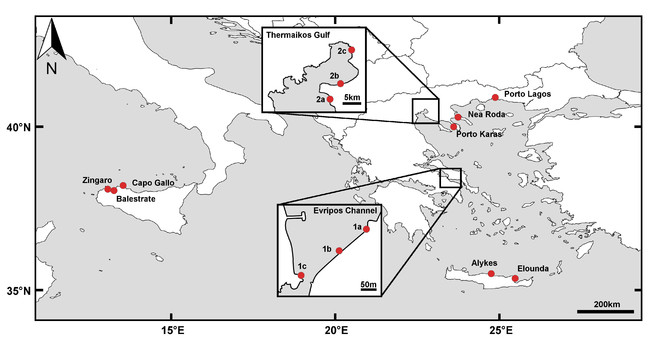
Alykes and Elounda: Both sampling sites are located on the North coast of Crete (Eastern Mediterranean) and are characterised by a continuous hard bottom habitat with dense algal coverage (Cystoseira spp., Sargassum sp., Corallinales spp.) and a moderate wave exposure. The area of Alykes has on average a denser algal coverage than the area of Elounda. The intertidal substrate is dominated by limestone rocks. None of the sites is impacted by detectable anthropogenic activity, though a sandy beach in ca 500 m distance of the sampling area in Elounda is subjected to moderate beach tourism and increased leisure boat traffic in the summer months.
Evripos channel: The area is located in the town of Chalkida (Euboea, Eastern Mediterranean) and is characterised by strong hydrodynamic changes caused by strong tidal currents. The midlittoral zone of this channel is an artificial hard bottom habitat (concrete). Three stations were chosen in this area with different levels of hydrodynamism: Evripos_1a with low, Evripos_1b with moderate and Evripos_1c with high hydrodynamic intensity. Evripos_1a is characterised by dense photophilous algal coverage dominated by Corallina elongata. Evripos_1b is covered by photophilous macroalgae (60%) and by the mollusk Mytilus galloprovincialis (40%). Finally, the station Evripos_1c is characterised by high densities of M. galloprovincialis. Despite their urban location, the stations are not noticeably affected by organic discharges since the strong currents prevailing in the area dissipate pollution.
Thermaikos Gulf: Thermaikos Gulf is an embayment in the North part of the Aegean Sea (Eastern Mediterranean) and is strongly impacted by urban pollution. The midlittoral zone sampled here is an artificial hard bottom habitat (concrete). At this site, three stations were sampled, with an increase of pollution intensity from station Thermaikos_2a to Thermaikos_2c. The station Thermaikos_2a is located in Nea Mixaniona and is characterised by low hydrodynamic intensity. The algal coverage at this station is dominated by the macroalga Antithamnion cruciatum. The station Thermaikos_2b is located in Neoi Epivates and receives intense wave action. The substrate of this station is covered by beds of the mollusk Mytilus galloprovincialis. The station Thermaikos_2c is located in front of the Thessaloniki Concert Hall and is sheltered from strong waves. The substrate of this station is covered by the mollusk M. galloprovincialis and the alga Ulva lactuca.
Nea Roda and Porto Karas: Both areas are located in Chalkidiki (North Aegean Sea, Eastern Mediterranean) but differ in terms of wave exposure: Nea Roda is moderately exposed, Porto Karas sheltered. The substrate in Nea Roda consists of granite, in Porto Karas the substrate is artificial (concrete). Mollusks are the dominant taxon in Nea Roda, whereas the midlittoral zone of Porto Karas is characterised by low densities of photophilous macroalgae. Nea Roda is a pristine area, whereas the stations in Porto Karas are located in a typical hotel marina and are subjected to slightly increased levels of organic pollution.
Porto Lagos: The sampling stations are located in a small port in Vistonicos Gulf (North Aegean Sea, Eastern Mediterranean) and is characterised by low-intensity hydrodynamism, low salinity and an artificial substrate (concrete). The midlittoral zone is dominated by the polychaete Ficopomatus enigmaticus which forms extensive biogenic calcareous layers of 3-4 cm height. Inside the port area, slightly increased levels of organic pollutions were detected.
Balestrate and Zingaro: Both areas are located in the Gulf of Castellammare. Balestrate is an outcrop of calcarenitic rocks surrounded by sand and is located in the centre of the Gulf. In this area, Sabellaria alveolata reefs temporarily proliferated between 1984–89 (preceding the sampling activities) in the infralittoral and midlittoral layers as a consequence of a wine distillery outfall. In the midlittoral zone, S. alveolata was associated with Mytilaster spp. beds. Zingaro, now a terrestrial and coastal reserve without influences from major anthropogenic stressors, is a steep calcareous cliff that stretches along the westernmost side of the Gulf. The midlittoral zone is characterised by the presence of vermetid reefs formed by the mollusk Dendropoma petraeum. Both areas are exposed to moderate wave action.
Capo Gallo: Capo Gallo, now a marine protected area, is a steep calcareous cliff located at the northern end of the Gulf of Palermo, not far from the city of Palermo. As in Zingaro, the midlittoral zone is characterised by the presence of vermetid reefs formed by the mollusk Dendropoma petraeum. The area is exposed to the dominant wind direction, resulting in increased wave action at the shore. No major sources of pollution are present in the vicinity.
Sampling methods
The data cover several independent sampling events over a time period of 25 years (1984–2009) and originate from 14 sampling sites in Italy and Greece (Mediterranean Sea). Samples were collected from the midlittoral zone from a maximum depth of 1.5 m. Concerning the distribution of polychaetes, this habitat is understudied in the Mediterranean Sea — in fact, the Ocean Biogeographic Information System contains less than 300 polychaete distribution records in the depth range of 0–5 m for the entire Mediterranean Sea, and none of these are from the intertidal zone. The present dataset thus provides an important addition to the exiting data for this habitat in the region (Fig.
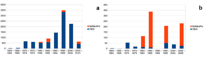
Temporal distribution of the number of polychaete records in the Mediterranean Sea present in the Ocean Biogeographic Information System (OBIS) and new contributions by the MidMedPol dataset. Only records from OBIS that contain information about the collection year were included, and data from before 1960 were omitted for reasons of clarity. a number of records for all depths, b number of records in the depth range of 0–5m. Diagrams based on the data from Suppl. material
Samples from Crete were collected from two sites, Alykes and Elounda. Both sites were sampled in September 2007, Alykes in June 2008 and Elounda in February 2009. Strong wave action prevented the site in Elounda from being sampled concurrently with the site in Alykes during the second year. Samples were collected according to the NaGISA protocol (
Samples from Evripos channel, Thermaikos Gulf, Chalkidiki and Porto-Lagos were collected from September 1997 until October 1997. At each site, five random replicate units were collected. Two kind of samplers were used: (a) a metallic frame (20x20 cm) with a 0.5 mm mesh bag attached to its upper part (
Samples from Italy were collected in 1984, 1986 and 1989. In Zingaro, samples were collected in spring of 1984, in Capo Gallo in spring, autumn and winter of 1986 and in Balestrate once per season in 1989. The number of replicate units per sample vary between 4 and 13. Samples were collected by scraping the surface of a 20x20 cm square, stored in plastic bags and subsequently fixed in a 5% solution of sea water and formalin.In the laboratory, samples were sieved through a 0.5 mm mesh size and preserved in 75% ethanol. Polychaetes were sorted into families and then identified to species level using various identification keys.
All scientific names were standardised against the World Register of Marine species using the Taxon Match tool (http://www.marinespecies.org/aphia.php?p=match). If recent taxonomic reviews were available that had not been incorporated into WoRMS at the time of standardisation, nomenclature follows those reviews. Subjective synonyms were kept in the dataset as they had been originally recorded, with a reference to the currently accepted name.
The samples had been obtained independently by three different research teams over a period of 25 years as described in detail above. In an attempt to assemble polychaete occurrence data of the Mediterranean midlittoral zone, the datasets included in this study were obtained from the respective colleagues, cross-checked, annotated, quality-controlled and transformed into a standard electronic format (Fig.
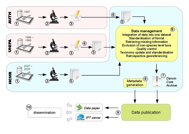
Overview of all steps leading to the final release of the dataset: 1 sampling, independently performed at the three different institutions (AUTH = Aristotle University of Thessaloniki, UNIPA = University of Palermo, HCMR = Hellenic Centre for Marine Research) 2 identification of polychaete specimens in the laboratory 3 data in paper-based format 4 digitisation 5 data in electronic format (spreadsheets) 6 integration of the three independent datasets into a standardised format, exclusion of records not identified to species level, retrieval of missing information, georeferencing of coordinates through Google Maps, standardisation of taxonomy against the World Register of Marine Species and recent literature, general quality control 7 export of data as a DarwinCore Archive 8 generation of dataset-level metadata 9 publication of the data as a data paper and through an IPT server 10 in the future, further dissemination of data by integration into other databases, personal downloads, archiving, etc.
Geographic coverage
Samples were collected at 14 sampling sites in Italy and Greece, Mediterranean Sea, from a maximum depth of 1.5 m (Table
The present dataset contains the first electronically available quantitative data on midlittoral polychaetes in the entire Mediterranean Sea. Previous studies of the habitat in the region are scarce, often qualitative and not electronically available.
35.261249 and 41.005812 Latitude; 25.75173 and 12.8027 Longitude.
Taxonomic coverage
Kingdom: Animalia
Phylum: Annelida
Class: Polychaeta
Orders: Sabellida, Terebellida, Eunicida, Phyllodocida, Amphinomida, Scolecida, Spionida
Common names: Bristle worms, segmented worms
The original dataset comprises distribution information for 123 polychaete species in 22 families. However, following recent taxonomic literature, several of the 127 species are currently regarded as synonyms. The present dataset, after updating the taxonomy, contains therefore distribution records for 123 species (Table
Taxa identified to species-level are included in the dataset and new records for the geographic areas.
| Family | Species |
New record for area | References used for identification |
| Amphinomidae | Chloeia venusta Quatrefages, 1866 | ||
| Aphroditidae | Pontogenia chrysocoma (Baird, 1865) | ||
| Capitellidae | Capitella capitata (Fabricius, 1780) | ||
| Capitellidae | Dasybranchus caducus (Grube, 1846) | ||
| Chrysopetalidae | Chrysopetalum debile (Grube, 1855) | ||
| Cirratulidae | Aphelochaeta filiformis (Keferstein, 1862) | ||
| Cirratulidae | Aphelochaeta marioni (de Saint Joseph, 1894) | ||
| Cirratulidae | Caulleriella alata (Southern, 1914) | ||
| Cirratulidae | Cirriformia chrysoderma (Claparède, 1869) | ||
| Cirratulidae | Dodecaceria concharum Örsted, 1843 | ||
| Cirratulidae | Timarete filigera (Delle Chiaje, 1828) | ||
| Dorvilleidae | Schistomeringos rudolphii (delle Chiaje, 1828) | ||
| Eunicidae | Eunice purpurea Grube, 1866 | ||
| Eunicidae | Eunice torquata Quatrefages, 1866 | ||
| Eunicidae | Lysidice collaris Grube, 1870 | ||
| Eunicidae | Lysidice ninetta Audouin & Milne-Edwards, 1833 | ||
| Eunicidae | Marphysa fallax Marion & Bobretzky, 1875 | ||
| Eunicidae | Marphysa sanguinea (Montagu, 1815) | ||
| Eunicidae | Nematonereis unicornis (Grube, 1840) | ||
| Eunicidae | Palola siciliensis (Grube, 1840) | ||
| Lumbrineridae | Lumbrineris coccinea (Renier, 1804) | ||
| Lumbrineridae | Lumbrineris inflata Moore, 1911 | ||
| Lumbrineridae | Scoletoma funchalensis (Kinberg, 1865) | ||
| Lumbrineridae | Scoletoma impatiens (Claparède, 1868) | ||
| Maldanidae | Praxillella gracilis (M. Sars, 1861) | ||
| Nereididae | Ceratonereis costae (Grube, 1840) | ||
| Nereididae | Neanthes caudata (Delle Chiaje, 1827) | ||
| Nereididae | Neanthes fucata (Savigny in Lamarck, 1818) | Aegean Sea, Greece |
|
| Nereididae | Neanthes nubila (Quatrefages, 1865) | ||
| Nereididae | Nereis splendida Grube, 1840 | ||
| Nereididae | Nereis lamellosa Ehlers, 1864 | ||
| Nereididae | Nereis pelagica Linnaeus, 1758 | ||
| Nereididae | Nereis perivisceralis Claparède, 1868 | Eastern Mediterranean |
|
| Nereididae | Nereis pulsatoria (Savigny, 1822) | ||
| Nereididae | Nereis rava Ehlers, 1864 | ||
| Nereididae | Perinereis cultrifera (Grube, 1840) | ||
| Nereididae | Perinereis macropus (Claparède, 1870) | ||
| Nereididae | Platynereis dumerilii (Audouin & Milne Edwards, 1834) | ||
| Nereididae | Pseudonereis anomala Gravier, 1900 | ||
| Nereididae | Websterinereis glauca (Claparède, 1870) | ||
| Oenonidae | Arabella geniculata (Claparède, 1868) | ||
| Opheliidae | Polyophthalmus pictus (Dujardin, 1839) | ||
| Orbiniidae | Protoaricia oerstedi (Claparède, 1864) | ||
| Pholoidae | Pholoe inornata Johnston, 1839 | ||
| Phyllodocidae | Eulalia clavigera (Audouin & Milne Edwards, 1833) | Aegean Sea, Greece |
|
| Phyllodocidae | Eulalia viridis (Linnaeus, 1767) | ||
| Phyllodocidae | Eumida sanguinea (Örsted, 1843) | ||
| Phyllodocidae | Mysta picta (Quatrefages, 1865) | ||
| Phyllodocidae | Nereiphylla rubiginosa (Saint-Joseph, 1888) | ||
| Phyllodocidae | Phyllodoce macrophthalma Schmarda, 1861 | ||
| Phyllodocidae | Phyllodoce madeirensis Langerhans, 1880 | ||
| Phyllodocidae | Pterocirrus macroceros (Grube, 1860) | ||
| Polynoidae | Lepidonotus clava (Montagu, 1808) | ||
| Sabellariidae | Sabellaria alcocki Gravier, 1906 | ||
| Sabellariidae | Sabellaria alveolata (Linnaeus, 1767) | ||
| Sabellariidae | Sabellaria spinulosa Leuckart, 1849 | ||
| Sabellidae | Amphiglena mediterranea (Leydig, 1851) | ||
| Sabellidae | Branchiomma lucullanum (Delle Chiaje, 1828) | ||
| Sabellidae | Chone collaris Langerhans, 1881 | ||
| Sabellidae | Demonax brachychona (Claparède, 1870) | ||
| Sabellidae | Oriopsis armandi (Claparède, 1864) | ||
| Sabellidae | Pseudopotamilla reniformis (Bruguière, 1789) | ||
| Serpulidae | Ficopomatus enigmaticus (Fauvel, 1923) | ||
| Serpulidae | Hydroides dianthus (Verrill, 1873) | ||
| Serpulidae | Hydroides elegans (Haswell, 1883) | ||
| Serpulidae | Janua pagenstecheri (Quatrefages, 1865) | ||
| Serpulidae | Pileolaria militaris Claparède, 1868 | ||
| Serpulidae | Serpula concharum Langerhans, 1880 | ||
| Serpulidae | Serpula vermicularis Linnaeus, 1767 | ||
| Serpulidae | Simplaria pseudomilitaris (Thiriot-Quievreux, 1965) | ||
| Serpulidae | Spirobranchus lamarcki (Quatrefages, 1866) | ||
| Serpulidae | Spirobranchus polytrema (Philippi, 1844) | ||
| Serpulidae | Spirorbis marioni Caullery & Mesnil, 1897 | ||
| Serpulidae | Vermiliopsis infundibulum (Philippi, 1844) | ||
| Serpulidae | Vermiliopsis striaticeps (Grube, 1862) | ||
| Spionidae | Dipolydora armata (Langerhans, 1880) | ||
| Spionidae | Dipolydora flava (Claparède, 1870) | ||
| Spionidae | Polydora ciliata (Johnston, 1838) | ||
| Spionidae | Polydora hoplura Claparède, 1869 | ||
| Syllidae | Branchiosyllis exilis (Gravier, 1900) | ||
| Syllidae | Brania pusilla (Dujardin, 1851) | ||
| Syllidae | Exogone dispar (Webster, 1879) | ||
| Syllidae | Haplosyllis spongicola (Grube, 1855) | ||
| Syllidae | Myrianida convoluta (Cognetti, 1953) | ||
| Syllidae | Myrianida edwardsi (Saint Joseph, 1887) | ||
| Syllidae | Myrianida prolifera (O.F. Müller, 1788) | ||
| Syllidae | Myrianida quindecimdentata (Langerhans, 1884) | ||
| Syllidae | Odontosyllis ctenostoma Claparède, 1868 | ||
| Syllidae | Odontosyllis gibba Claparède, 1863 | ||
| Syllidae | Opisthosyllis brunnea Langerhans, 1879 | ||
| Syllidae | Paraehlersia ferrugina (Langerhans, 1881) | ||
| Syllidae | Prosphaerosyllis xarifae (Hartmann-Schröder, 1960) | ||
| Syllidae | Salvatoria clavata (Claparède, 1863) | ||
| Syllidae | Salvatoria neapolitana (Goodrich, 1930) | ||
| Syllidae | Sphaerosyllis bulbosa Southern, 1914 | ||
| Syllidae | Sphaerosyllis hystrix Claparède, 1863 | ||
| Syllidae | Sphaerosyllis ovigera Langerhans, 1879 | ||
| Syllidae | Sphaerosyllis pirifera Claparède, 1868 | ||
| Syllidae | Syllis amica Quatrefages, 1866 | ||
| Syllidae | Syllis armillaris (O.F. Müller, 1776) | ||
| Syllidae | Syllis beneliahuae (Campoy & Alquézar, 1982) | ||
| Syllidae | Syllis cf mayeri. Musco & Giangrande, 2005 | Aegean Sea, Greece | |
| Syllidae | Syllis columbretensis (Campoy, 1982) | ||
| Syllidae | Syllis compacta Gravier, 1900 | ||
| Syllidae | Syllis corallicola Verrill, 1900 | ||
| Syllidae | Syllis cornuta Rathke, 1843 | ||
| Syllidae | Syllis garciai (Campoy, 1982) | ||
| Syllidae | Syllis gerlachi (Hartmann-Schröder, 1960) | ||
| Syllidae | Syllis golfonovensis (Hartmann-Schröder, 1962) | ||
| Syllidae | Syllis gracilis Grube, 1840 | ||
| Syllidae | Syllis hyalina Grube, 1863 | ||
| Syllidae | Syllis kabilica Ben-Eliahu, 1977 | Italy | |
| Syllidae | Syllis krohni Ehlers, 1864 | ||
| Syllidae | Syllis prolifera Krohn, 1852 | ||
| Syllidae | Syllis rosea (Langerhans, 1879) | ||
| Syllidae | Syllis variegata Grube, 1860 | ||
| Syllidae | Syllis vittata Grube, 1840 | ||
| Syllidae | Syllis westheidei San Martín, 1984 | ||
| Syllidae | Trypanosyllis coeliaca Claparède, 1868 | ||
| Syllidae | Trypanosyllis zebra (Grube, 1840) | ||
| Terebellidae | Nicolea venustula (Montagu, 1818) | ||
| Terebellidae | Amphitritides gracilis (Grube, 1860) | ||
| Terebellidae | Terebella lapidaria Linnaeus, 1767 |
The species richness of the 22 families is very heterogeneous. Syllidae are the family with the highest species richness, comprising 33.3% of the species in the dataset, followed by Nereididae with 12.6% of the found species and Serpulidae with 10.6% (Fig.
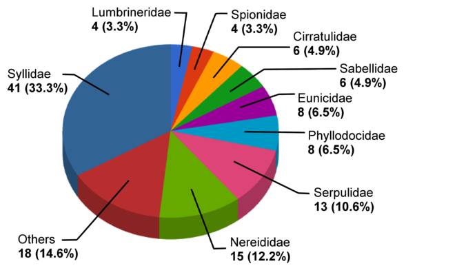
Distribution of species per family (abundance and percentage) for the most species-rich families in the MidMedPol dataset. Families with less than four species were combined in the category "Others". These are: Sabellariidae, Terebellidae (3 species each), Capitellidae (2 species), Amphinomidae, Aphroditidae, Chrysopetalidae, Dorvilleidae, Maldanidae, Oenonidae, Opheliidae, Orbiniidae, Pholoidae and Polynoidae (1 species each). Diagram based on the data from Suppl. material
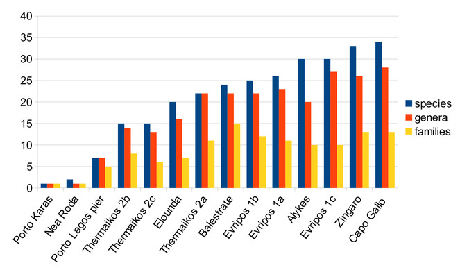
Species richness at the different sampling sites is very heterogenous, with only a single species found in Porto Karas to 34 species found in Capo Gallo. Likewise, the number of higher taxa is different across locations, e.g. the 24 species recorded in Balestrate belong to 15 different families, whereas the 30 species recorded each in Alykes and Evripos St. 1c belong to only 10 families (Fig.
Temporal coverage
Usage rights
The dataset can be freely used provided it is cited.
Data resources
The dataset is available via the GBIF Internet Publishing Toolkit (IPT) of the Flanders Marine Institute (VLIZ). This IPT installation serves as the European node of the Ocean Biogeographic Information System (EurOBIS). The data will also be harvested by and made available through the International OBIS database, as well as through the data portal of the Global Biodiversity Information Facility (GBIF). The dataset is available as a DarwinCoreArchive, all fields are mapped to DarwinCore terms (http://rs.tdwg.org/dwc/).
This publication refers to the most recent version of the dataset available through the IPT server or EurOBIS. Future changes to the dataset due to quality control activities might change its content or structure.
| Column label | Column description |
|---|---|
| recordNumber | A unique identifier for the record within the data set or collection. |
| scientificName | The scientific name of the taxon, including authorship. |
| scientificNameAuthorship | The authorship information for the scientificName formatted according to the conventions of the applicable nomenclaturalCode. |
| acceptedNameUsage | The full name, with authorship and date information if known, of the currently valid (zoological) taxon. |
| taxonRemarks | Comments or notes about the taxon or name. |
| specificEpithet | The species epithet of the scientificName. |
| identificationQualifier | A brief phrase or a standard term ("cf.", "aff.") to express the determiner's doubts about the Identification. |
| genus | The full scientific name of the genus in which the taxon is classified. |
| family | The full scientific name of the family in which the taxon is classified. |
| order | The full scientific name of the orde in which the taxon is classified. |
| class | The full scientific name of the class in which the taxon is classified. |
| phylum | The full scientific name of the phylum in which the taxon is classified. |
| kingdom | The full scientific name of the kingdom in which the taxon is classified. |
| fieldNumber | Denotes the code of each replicate unit. |
| fieldNotes | Notes about this occurrence record. |
| EventDate | The sampling date. |
| verbatimEventDate | The verbatim expression of the sampling date. |
| year | The sampling year. |
| month | The sampling month. |
| day | The sampling day. |
| locality | The specific location where the sample was taken. |
| municipality | The full, unabbreviated name of the next smaller administrative region than county (city, municipality, etc.) in which the sampling location occurs. |
| island | The name of the island on or near which the sampling location occurs. |
| country | The name of the country in which the sampling location occurs. |
| countryCode | The standard code of the country in which the sampling location occurs. |
| continent | The name of the continent in which the sampling location occurs. |
| waterBody | The name of the water body in which the sampling location occurs. |
| decimalLatitude | The geographic latitude (in decimal degrees, using the spatial reference system given in geodeticDatum) of the geographic center of a Location. Positive values are north of the Equator, negative values are south of it. Legal values lie between -90 and 90, inclusive. |
| decimalLongitude | The geographic longitude (in decimal degrees, using the spatial reference system given in geodeticDatum) of the geographic center of a Location. Positive values are east of the Greenwich Meridian, negative values are west of it. Legal values lie between -180 and 180, inclusive. |
| GeoreferenceSources | A list (concatenated and separated) of maps, gazetteers, or other resources used to georeference the Location, described specifically enough to allow anyone in the future to use the same resources. |
| coordinateUncertaintyInMeters | The horizontal distance (in meters) from the given decimalLatitude and decimalLongitude describing the smallest circle containing the whole of the sampling location. |
| habitat | A category or description of the habitat from which the samples were collected. |
| minimumDepthInMeters | The lesser depth of a range of depth below the local surface, in meters. |
| maximumDepthInMeters | The greater depth of a range of depth below the local surface, in meters. |
| samplingProtocol | The description of the method or protocol used for sample collection. |
| basisOfRecord | The specific nature of the data record, as described in http://rs.tdwg.org/dwc/terms/type-vocabulary/index.htm. |
| preparations | Preparations and preservation methods for a specimen. |
| individualCount | The number of individuals in a replicate sample unit. In cases where replicates had been pooled, the average abundances are not included under "individualCount" but under "dynamicProperties" |
| dynamicProperties | Includes here as the only attribute "meanAbundance". These are the average abundances of those samples where the replicates had been pooled. |
| recordedBy | A list (concatenated and separated) of names of people responsible for recording the original Occurrence. |
| identifiedBy | A list (concatenated and separated) of names of people, groups, or organizations who identified the specimen. |
| dateIdentified | The date on which the specimen was identified. |
| identificationReferences | A list (concatenated and separated) of references (publication, global unique identifier, URI) used for identifying the specimen. |
| institutionCode | The name (or acronym) in use by the institution having custody of the object(s) or information referred to in the record. |
| institutionID | An identifier for the institution having custody of the object(s) or information referred to in the record. |
| datasetID | An identifier for the set of data. |
| datasetName | The name identifying the data set from which the record was derived. |
| rights | Information about rights held in and over the resource (copyright, intellectual property, etc.). |
| rightsHolder | A person or organization owning or managing rights over the resource. |
| id | A unique identifier for the record within the data set or collection, auto-incrementing number automatically added by the system. |
| taxonID | Aphia ID (Unique Identifier for the taxon within the World Register of Marine Species - www.marinespecies.org) |
Additional information
Resource citation
Keklikoglou, K., Faulwetter, S., Chatzigeorgiou, G., Badalamenti, F., Kitsos, MS., Arvanitidis, C. (2013). MidMedPol: Polychaetes from midlittoral rocky shores in Greece and Italy (Mediterranean Sea). 788 records, Contributed by Arvanitidis, C., Chatzigeorgiou, G., Faulwetter, S., Keklikoglou, K., Badalamenti, F., Kitsos, MS., Tyberghein, L., Plaiti, W., Markantonatou, V., Pesmatzoglou, I., Fernandez R. and students from Niceville High School, FL, USA and Ousantzopoulou K. and students from Heraklion High School of Arts, Crete, Greece, Online http://ipt.vliz.be/resource.do?r=mediterraneanpolychaetaintertidal, Version 1.0. Data Paper ID: doi: 10.3897/BDJ.1.e961
References
- Syllidae (Polychaeta) from Lebanon with two new reports for the Mediterranean Sea.Cahiers de Biologie Marine48:207‑224.
- MedOBIS: biogeographic information system for the eastern Mediterranean and Black Sea.Marine Ecology Progress Series316:225‑230. https://doi.org/10.3354/meps316225
- The Aphroditoidea (Annelida: Polychaeta) of the Mediterranean Sea.Abhandlungen der Senckenbergischen Naturforschenden Gesellschaft559:1‑167.
- A comparison between species diversities of polychaetes from tropical temperate structurally similar rocky intertidal habitats.Journal of Biogeography9:371‑390. https://doi.org/10.2307/2844570
- Distribution of a population of annelid polychaetes in the “trottoir” of the midlittoral zone on the coast of North-East Spain, Western Mediterranean.Marine Biology99:83‑92. https://doi.org/10.1007/BF00644980
- Revision of Lumbrineris de Blainville, 1828 (Polychaeta: Lumbrineridae).Zootaxa1336:1‑64.
- A population of the sea anemone Anemonia viridis (Főrskal, 1775) and its associated flora and fauna, in the North Aegean Sea.Internationale Revue der gesamten Hydrobiologie und Hydrographie77:483‑495. https://doi.org/10.1002/iroh.19920770311
- Impacts of sea-level rise on deltas in the Gulf of Mexico and the Mediterranean: The importance of pulsing events to sustainability.Estuaries18(4):646‑647. https://doi.org/10.2307/1352382
- The polychaete worms, definitions and keys to the orders, families and genera.Natural History Museum of Los Angeles County,Los Angeles,188pp.
- Faune de France: Polychètes errantes.Fédération Française des Sociétés de Sciences Naturelles,Paris,488pp.
- Faune de France: Polychètes Sédentaires.Lechevalier,Paris,494pp.
- Polychaetes as environmental indicators revisited.Marine Pollution Bulletin50(11):1153‑1162. https://doi.org/10.1016/j.marpolbul.2005.08.003
- Polychaeta Terebellomorpha.Marine Invertebrates of Scandinavia7:1‑192.
- Natural Geography in Nearshore Areas (NaGISA): the nearshore component of the Census of Marine Life.Gayana67:153‑160.
- Polychaetes as surrogates for marine biodiversity: lower taxonomic resolution and indicator groups.Biodiversity and Conservation12:1033‑1049. https://doi.org/10.1023/A:1022800405253
- Nouveau manuel de bionomie benthique de la mer Méditerranée.Recueil des Travaux de la Station Marine d' Endoume31(47):1‑137.
- San Martín G (1984) Estudio biogeográfico, faunistico y sistemático de los poliquetos de la familia Silidos (Syllidae: Polychaeta) en Baleares.Universidad Complutense de Madrid,Madrid,529pp.
- Annelida Polychaeta II: Syllidae.Museo Nacional de Ciencias Naturales,Madrid,554pp.
- Polychaete communities related to plant covering in the mediolittoral and infralittoral zones of the Balearic Islands (Western Mediterranean).P.S.Z.N.I: Marine Ecology12(4):341‑360. https://doi.org/10.1111/j.1439-0485.1991.tb00263.x
- The universal features of zonation between tide-marks on rocky coasts.Journal of Ecology37(2):289‑305. https://doi.org/10.2307/2256610
- Taxonomy of Serpulidae (Annelida, Polychaeta): The state of affairs.Zootaxa2036:1‑126.
- Fauna Iberica: Annelida Polychaeta I.Annelida Polychaeta I,25.Museo Nacional de Ciencias Naturales, Consejo Superior de Investigaciones Cientificas,530pp.
Supplementary materials
Number of polychaete records in the Mediterranean in five-year intervals since 1960. Data from the Ocean Biogeographic information system, plus additions from the present dataset.
Summary of the number of species per family.
Overview of the number of taxa per sampling station