|
Biodiversity Data Journal :
Data Paper (Biosciences)
|
|
Corresponding author:
Academic editor: Christos Arvanitidis
Received: 02 Aug 2016 | Accepted: 25 Aug 2016 | Published: 01 Nov 2016
© 2016 Irini Tsikopoulou, Aglaia Legaki, Panagiotis Dimitriou, Evangelia Avramidou, Nicolas Bailly, Stamatina Nikolopoulou
This is an open access article distributed under the terms of the Creative Commons Attribution License (CC BY 4.0), which permits unrestricted use, distribution, and reproduction in any medium, provided the original author and source are credited.
Citation:
Tsikopoulou I, Legaki A, Dimitriou P, Avramidou E, Bailly N, Nikolopoulou S (2016) Digging for historical data on the occurrence of benthic macrofaunal species in the southeastern Mediterranean. Biodiversity Data Journal 4: e10071. https://doi.org/10.3897/BDJ.4.e10071
|
|
Abstract
Background
The benthic macrofaunal biodiversity of the southeastern Mediterranean is considerably understudied compared to other Mediterranean regions. Monitoring biodiversity in this area is crucial as this region is particularly susceptible to biological invasions and temperature alteration. Historical biodiversity data could provide a useful baseline for monitoring potential changes and provide informarion to support a better understanding of the possible effects of anthropogenic activities on marine benthic communities.
New information
In this study, performed under the LifeWatchGreece Research Infrastructure, we present historical benthic occurrence data obtained from the sampling expedition carried out in 1933 by Adolf Steuer in the coastal area around Alexandria, Egypt, eastern Mediterranean. The occurrences were geo-referenced to more than 170 stations, mostly located in the area of Alexandria, and the nearby coasts and lakes. All records were digitized and species names were cross-checked and taxonomically updated using the World Register of Marine Species. The outcome clearly shows that such initiatives can reveal an unexpected amount of highly valuable biodiversity information for “data-poor” regions.
Keywords
marine biodiversity, macrofauna, Egypt expedition, eastern Mediterranean, historical dataset, data digitization, data rescue
Introduction
At the beginning of the 20th century, the importance of recording marine biodiversity was already recognized. Numerous expeditions had been organized with the aim of investigating “local fauna and flora” in various areas of the world. In 1924, Cambridge Expedition at the Suez Canal recorded the fauna of the Red Sea (
In this study, we present occurrence data which were digitized from 14 publications on the Egypt Expedition under the general report "The fishery grounds near Alexandria" made by Adolf Steuer and his colleagues and published between 1935-1940. Twelve of these publications included occurrence data on twelve macrofaunal groups and two of them were preliminary reports which described the sampling protocols that were followed during the expedition (Table
Taxa and related published volumes and information included in "The fishery grounds near Alexandria" dataset
| Taxon name in original dataset | Accepted Taxon name | Volume | Author | Date | Title | Download URL |
| - | - | 8 | A.Steuer | 1935 | I. - Preliminary report | http://ipt.medobis.eu/resource?r=egyptexpeditionpreliminaryrepor |
| - | - | 9 | A. Vatova | 1935 | II. A bottom sample taken at Alexandria | http://ipt.medobis.eu/resource?r=egyptexpeditionbottomsampler |
| Cirripeds | Cirripedia | 10 | H. Broch | 1935 | III. - Cirrepeds | http://ipt.medobis.eu/resource?r=egyptexpeditioncirripeds |
| Hydroidea | Hydrozoa | 13 | A. Billard | 1936 | VI. - Hydroidea | http://ipt.medobis.eu/resource?r=egyptexpeditionhydroidea |
| Decapoda | Decapoda | 15 | H. Balss | 1936 | VII. Decapoda | http://ipt.medobis.eu/resource?r=egyptexpeditiondecapoda |
| Pantopoda | Pantopoda | 16 | H. Helfer | 1936 | VIII. - Pantopoda | http://ipt.medobis.eu/resource?r=egyptexpeditionpantopoda |
| Amphipoda | Amphipoda | 18 | A. Schellenberg | 1936 | X. - Amphipoda Benthonica | http://ipt.medobis.eu/resource?r=egyptexpeditionamphipoda |
| Annelides Polychetes | Polychaeta | 19 | P. Fauvel | 1937 | XI. - Annelides Polychetes | http://ipt.medobis.eu/resource?r=egyptexpeditionpolychaeta |
| Echinoderma | Echinodermata | 21 | Th. Mortensen & Ad. Steuer | 1937 | XIII. - Echinoderma | http://ipt.medobis.eu/resource?r=egyptexpeditionechinoderma |
| Cumacea, Stomatopoda, Leptostraca | Cumacea, Stomatopoda, Leptostraca | 26 | A. Steuer | 1938 | XVI. Cumacea, stomatopoda, leptostraca | http://ipt.medobis.eu/resource?r=egyptexpeditioncumaceastomatopodaleptostacaea |
| Ascidiacea | Ascidiacea | 28 | H. Harant | 1939 | XVii. Ascidiacea | http://ipt.medobis.eu/resource?r=egyptexpeditionascidiacea |
| Sipunculoidea, Phoronidea, Brachiopoda, Enteropneusta, Arcania | Sipuncula, Phoronida, Brachiopoda, Enteropneusta, Arcania | 30 | A. Steuer | 1939 | XVIII. - Sipunculoidea, Phoronidea, Brachiopoda, Enteropneusta and Arcania | http://ipt.medobis.eu/resource?r=egyptexpeditionsipunculoideaphoronidaebrachiopodaenteropneustaacrania |
| Mollusca | Mollusca | 33 | A. Steuer | 1939 | XIX. - Mollusca | http://ipt.medobis.eu/resource?r=egyptexpeditionmollusca |
| Tanaidacea, Isopoda | Tanaidacea, Isopoda | 35 | H. J. Larwood | 1940 | XXI. Tanaidacea and Isopoda | http://ipt.medobis.eu/resource?r=egyptexpeditiontanaidaceaisopoda |
Project description
Digitization of historical dataset - Egypt Expedition
This dataset combines the benthic macrofaunal data obtained from the floristical and faunistical survey of A. Steuer in the coasts near Alexandria in 1933. The results of this expedition were published in 38 volumes between 1934 and 1940. In this study, we present the digitized data of 14 volumes concerning macrofaunal taxa (1935-1940). In rare cases, occurrence data for planktonic species were available in these volumes and were included in the digitized datasets.
The datasets were digitized by the LifeWatchGreece data management team. Irini Tsikopoulou (data manager), Stamatina Nikolopoulou (data, database and webgis application manager) and Aglaia Legaki (data manager) were the resource creators, Panagiotis D. Dimitriou (data manager) and Evangelia Avramidou (data manager) were content providers. Nicolas Bailly has checked difficult taxonomic cases.
The original data were collected by Dr. Adolf Steuer, professor at the University of Innsbruck, who organized and led the sampling expedition to the coasts near Alexandria, Egypt. After sampling, all collected specimens were preserved and sent to several experts for taxonomic identification. Each expert was responsible for the publication of his macrofaunal report.
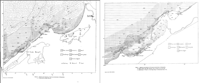
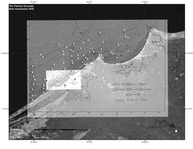
The study area of the Egypt Expedition is located between the Western and Eastern harbors of Alexandria, including nearby localities such as Abukir Bay, the Suez Canal and the lakes Edku and Mariout (Fig.
Data rescue/digitization
The digitization of this historical dataset was supported by the LifeWatchGreece Research Infrastructure, funded by the Greek Government under the General Secretariat of Research and Technology (GSRT), ESFRI Projects, Structural Funds, OPCE II.
Regarding the Egypt expedition, the Egyptian Ministry of Finance funded the whole sampling campaign and provided Dr Steuer with the expedition vehicle of the Marine Laboratory of Alexandria, a 15 m long motor boat named “El Hoot”. Additionally, the Ministry of Finance provided access to the Marine Laboratory of Alexandria located within the harbor area of the Alexandria city, as well as a small row boat, an automobile and the sampling equipment.
Sampling methods
Sampling took place at 172 locations in the marine area off Alexandria, in the Suez Canal, in the Nile river and in two lagoons (Lake Mariout and Lake Edku). Adolf Steuer was in charge of the sampling which lasted from April to November of 1933. A motor-launch (small military vessel) 15 m long, named "El Hoot", belonging to the Marine Laboratory, was used for the one-day trips at sea. Since it was difficult to sail too far from the shore, only two stations (station 26 and station 64) surpassed the 200 m isobath. In some cases a small rowing boat was also used. The collection of benthic samples was done almost exclusively by using a dredge with an opening of 20x70 cm. In only one case sampling was performed with a large otter trawl (bottom trawling) in the eastern part of Bay of Abukir, at a depth of 20 meters. A bottom sampler (Petersen's grab) of 0.2 m2 surface was also used once in the Eastern harbor due to difficulties in its manipulation (
Every single dataset was digitized manually from scanned documents. Some publications were in French or in German, depending on the author, and therefore the information was translated to English. Species names and sampling location names in the digitized datasets were kept same as in the original paper. Afterwards, all scientific names were cross-checked and taxonomically updated using the Taxon Match tool of the World Register of Marine Species (WoRMS) (
Digitization process
The digitization of the historical publications concerning the Egypt Expedition is a challenging process due to their complexity and the variety of the format across the different faunistic reports. Information on the sampling protocol and the sampling sites were digitized mainly based on the preliminary reports of
The digitization process of the Egypt Expedition datasets included several steps that are described below:
- Data managers read and comprehended individual faunistic publications, in order to overcome difficulties originating from the heterogeneity in the format and the content among the historical papers. The original authors did not follow a specific format for the presentation of their results. Some of them included species distribution maps, some reported species list, sampling dates and depths, while others also recorded individual species counts. If there was a species list in the historical papers, species were recorded according to their taxonomical classification. Respectively, if there was a station list, stations were reported chronologically.
- A spreadsheet was created for each faunistic report and were populated with original species names found at each location. In this stage of digitization process, obvious typographic errors were corrected. The spreadsheets also contained information on the sampling depth (minimum and maximum depth), sampling date (year, month, day), sampling protocol and habitat (substrate type and vegetation). For benthic samples, station depth and sampling depth were matched. In some faunistic reports, station depths were given in fathoms (i.e. approximately 1.8 meters). In these cases, station depths in the datasets were converted to meters. For some taxonomic groups, additional information such as sex, lifestage, individual counts or body length measurements were available, either on a species level or on a specimen level. Accepted taxon names and taxonomic classification, as derived from the World Register of Marine species, were also included in the spreadsheets.
- After the digitization of all available information contained in the main text and tables in the publications, sampling stations were georeferenced using the species distribution maps in every faunistic report. Since there were no stations coordinates, latitude, longitude and coordinates uncertainty were estimated using a GIS based on the distribution maps in each publication and in
Fauvel (1937) . In cases, where a station was only referred to as a specific locality in the text, and not accompanied by a symbol on a map, a new station with higher uncertainty was created based on the locality description. - In the next step, a code (fieldNumber) was created for each sampling event. A unique event was defined as a sampling event that took place in a specific station at a specific time and sampling depth using a specific sampling protocol. In some cases several samples had been taken in a location without defining the sampling station but only the wider area. To represent these, a new station ID was created, accompanied by an respective location remark. A code (occurrenceID) was also created for each species occurrence record.
- The outcome of the above digitization steps was twelve spreadsheets with 56 columns containing occurrence data of twelve benthic macrofaunal taxa. These tables were combined in the MedOBIS PostgreSQL database in order to correct mistakes originating from differences in the information or absence of information derived from Steuer's preliminary report (1935) and individual faunistic reports. In cases of corrections, original information was always kept as a remark in the dataset.
- The final step was the publication of the data through the MedOBIS Data Repository (MedOBIS IPT - http://ipt.medobis.eu/) and the MedOBIS Geoportal (http://medobis.portal.lifewatchgreece.eu/viewer). The Integrated Publishing Toolkit (IPT) (
Wieczorek and Braak 2015 , http://www.gbif.org/ipt) is a free open source software tool and is used to publish and share biodiversity datasets through the GBIF network (http://www.gbif.org/). It uses Darwin Core (http://rs.tdwg.org/dwc/terms/) and Ecological Metadata Language (EML) standards. All datasets are distributed as Darwin Core Archives, a compressed file that contains: one or more data files with details for event, occurrence and measurements in a comma-separated or tab-separated list, an archive descriptor (meta.xml) file describing the individual data file columns used and a metadata file on EML describing the entire dataset. The datasets concerning different taxonomic groups were published separately with their metadata and individual URLs (Table2 ). Since the repository does not currently support species measurements such as body and carapace length, this information is added in the supplementary files of the present paper (Suppl. material1 ), following the recently developed Environmental data and Event schema of OBIS (De Pooter et al., in prep). The datasets are also available on MedOBIS Geoportal (a virtual lab on LifeWatchGreece Research Infrastructure), where all the taxonomic groups are visualized on a map. The Geoportal allows users to search and download marine species datasets from all over the Mediterranean in several different formats (CSV, KML, WFS, WMS). In addition, a MedOBIS mobile application has been developed on playstore (https://play.google.com/store/apps/details?id=com.Hcmr.LifeWatch).
List of sampling stations, their locality, habitat characteristics and species richness
| a/a | Station Name | Locality | Latitude | Longitude | Coordinates uncertainty | Habitat | Number of species | Number of phyla |
| 1 | 1 | North of Abu Qir Bay |
|
|
200 | mud and stones, Halimeda | 19 | 4 |
| 2 | 2 | North of Pharo, Alexandria |
|
|
200 | Halimeda, sand, mud | 35 | 4 |
| 3 | 3 | North of Pharo, Alexandria |
|
|
200 | muddy, Halimeda, Caulerpa | 22 | 6 |
| 4 | 4 | Eastern Harbour, Alexandria |
|
|
200 | sand, Caulerpa | 24 | 4 |
| 5 | 5 | Eastern Harbour, Alexandria |
|
|
200 | Caulerpa, Codium, sand | 29 | 5 |
| 6 | 6 | Eastern Harbour, Alexandria |
|
|
200 | stony, Caulerpa | 5 | 3 |
| 7 | 7 | Close to Alexandria Harbour |
|
|
200 | small stones, Caulerpa | 38 | 5 |
| 8 | 8 | Close to Alexandria Harbour |
|
|
200 | small stones, Caulerpa, Halimeda | 14 | 5 |
| 9 | 9 | Western Harbour, Alexandria |
|
|
200 | mud with plants | 14 | 2 |
| 10 | 10 | Western Harbour, Port-Quest, Alexandria |
|
|
200 | Caulerpa, sand, mud | 16 | 4 |
| 11 | 11 | Western Harbour, Alexandria |
|
|
200 | smelling, black mud without algae | 19 | 4 |
| 12 | 12 | Western Harbour, Alexandria |
|
|
200 | Caulerpa, Posidonia, sand, some mud, Codium ground | 14 | 3 |
| 13 | 13 | Western Harbour, Alexandria |
|
|
200 | sand, some mud | 34 | 2 |
| 14 | 14 | Western Harbour, Alexandria |
|
|
200 | sandy, black mud with little Caulerpa and brown algae | 11 | 1 |
| 15 | 15 | Western Harbour, Alexandria |
|
|
200 | sand | 8 | 2 |
| 16 | 17 | Western Harbour, Port-Quest, Alexandria |
|
|
200 | little Caulerpa, sand, black mud | 14 | 4 |
| 17 | 18 | Western Harbour, Alexandria |
|
|
200 | very little Caulerpa, black mud | 5 | 1 |
| 18 | 19 | NW of Al Meks, Egypt |
|
|
200 | Caulerpa, sand | 4 | 1 |
| 19 | 20 | Off Al Meks, Egypt |
|
|
200 | Posidonia, Cymodocea | 6 | 3 |
| 20 | 21 | Near Dekheli, Egypt |
|
|
200 | Caulerpa, Posidonia, Amphioxus, brown algae | 22 | 6 |
| 21 | 22 | Great Pass, Alexandria |
|
|
200 | Posidonia, Caulerpa, brown algae, rocks, yellow sand | 19 | 4 |
| 22 | 23 | Margin of the Great-Pass, Alexandria |
|
|
200 | yellow Amphioxus sand, Halimeda, Udotea | 10 | 5 |
| 23 | 24 | Off Fort Ada |
|
|
200 | stony, Caulerpa, Halimeda | 8 | 4 |
| 24 | 25 | Infront of Fort Ada, Alexandria |
|
|
350 | Caulerpa, Halimeda, brown algae, seagrass | 11 | 4 |
| 25 | 26 | North of Al Max, Alexandria |
|
|
200 | soft and yellow mud with Pteropodes | 11 | 3 |
| 26 | 27 | North of El Anfushi Beach, Alexandria |
|
|
200 | mud with mollusc shells | 27 | 5 |
| 27 | 28 | Close to East Harbour, Alexandria |
|
|
200 | stones, Caulerpa, Halimeda | 37 | 5 |
| 28 | 29 | Close to East Harbour, Alexandria |
|
|
200 | stony, Caulerpa | 6 | 3 |
| 29 | 30 | Close to East Harbour, Alexandria |
|
|
200 | stones, Caulerpa | 14 | 6 |
| 30 | 31 | East Harbour, Port-Quest, Alexandria |
|
|
200 | sand, Caulerpa | 14 | 3 |
| 31 | 32 | Eastern Harbour, near entrance |
|
|
200 | coarse sand with stones and very little mud, Caulerpa | 37 | 5 |
| 32 | 35 | Off Sidi Bishr, Egypt |
|
|
200 | Caulerpa, Posidonia, Halimeda, rough sand with stones, Amphioxus, brown algae | 51 | 6 |
| 33 | 36 | Sidi Bischr |
|
|
200 | fine sand | 10 | 3 |
| 34 | 37 | Sidi Bischr |
|
|
200 | sandy, Caulerpa | 4 | 2 |
| 35 | 38 | NW of Abu Qir |
|
|
200 | Halimeda, Caulerpa, stony, brown algae | 8 | 5 |
| 36 | 39 | NW of Abu Qir |
|
|
200 | Caulerpa, sand, little mud | 9 | 4 |
| 37 | 40 | Abu Qir Bay |
|
|
200 | sand, stones, Amphioxus bottom | 11 | 4 |
| 38 | 41 | Crags at the eastern coast of Abu Qir Peninsula |
|
|
200 | crags with Cystoseira, Padina, little Caulerpa | 15 | 4 |
| 39 | 42 | Abu Qir, eastern coast |
|
|
200 | gray sand, mud, sea grass meadows | 15 | 4 |
| 40 | 43 | Western side of Abu Qir |
|
|
200 | crags, sand, brown algae, Posidonia, Caulerpa | 8 | 3 |
| 41 | 44 | Abu Qir Bay |
|
|
200 | fine rich slime | 4 | 3 |
| 42 | 45 | Abu Qir Bay |
|
|
200 | little sand, much mud | 7 | 5 |
| 43 | 47 | Abu Qir Bay |
|
|
200 | sandy with little mud | 7 | 3 |
| 44 | 48 | Lake Edku, seaside, sandy beach near the channel, in open water and upon stones of the bridge |
|
|
200 | shallow sand | 27 | 3 |
| 45 | 49 | Lake Edku, at the Bridge, near the canal with the Bay of Abu Qir, on shallow see-weed-bottom of the lake |
|
|
800 | shallow seagrass meadows | 9 | 3 |
| 46 | 50 | Off Abu Qir |
|
|
200 | sandy, stony, Amphioxus bottom | 20 | 5 |
| 47 | 51 | Abu Qir Bay |
|
|
200 | sandy ground, Amphioxus ground | 18 | 4 |
| 48 | 52 | North of Abu Qir |
|
|
200 | mud, Phoronis bottom | 24 | 5 |
| 49 | 53 | Off Abu Qir- Montazah |
|
|
200 | yellow mud, bottom with Enteropneustes | 24 | 5 |
| 50 | 54 | Northwest of Abu Qir Bay |
|
|
200 | 17 | 4 | |
| 51 | 55 | Northwest of Abu Qir Bay |
|
|
200 | mud | 25 | 4 |
| 52 | 56 | Abu Qir Bay |
|
|
200 | coarse Amphioxus sand, little Caulerpa | 9 | 4 |
| 53 | 57 | Abu Qir Bay |
|
|
200 | fine sand, Caulerpa | 21 | 3 |
| 54 | 58 | Abu Qir Bay |
|
|
200 | sandy ground with algae (Caulerpa) and seaweed (Cymodocea) | 23 | 4 |
| 55 | 60 | North of Sidi Bishr |
|
|
200 | mud, bottom with Enteropneustes | 8 | 4 |
| 56 | 61 | North of East Port of Alexandria |
|
|
200 | stones, mud, algae (one empty shell) | 60 | 5 |
| 57 | 62 | North of Pharo, Alexandria |
|
|
200 | mud, Caulerpa bottom | 27 | 5 |
| 58 | 63 | NW of Agami island |
|
|
200 | stony coarse sand and mud | 31 | 5 |
| 59 | 64 | NW of Agami island |
|
|
200 | muddy ground mixed with coarse sand | 23 | 6 |
| 60 | 65 | North of Agamy |
|
|
200 | sand, mud, little Caulerpa | 1 | 1 |
| 61 | 66 | North of West Port of Alexandria |
|
|
200 | sand, mud, Caulerpa | 18 | 3 |
| 62 | 67 | North of West Port of Alexandria |
|
|
200 | sand, mud | 22 | 4 |
| 63 | 68 | North of West Port of Alexandria |
|
|
200 | Caulerpa, mud | 14 | 4 |
| 64 | 69 | North of West Port of Alexandria |
|
|
200 | Caulerpa, mud | 15 | 4 |
| 65 | 71 | North of East Port of Alexandria |
|
|
200 | stony, Caulerpa, Halimeda | 2 | 2 |
| 66 | 72 | North of Pharo, Alexandria |
|
|
200 | muddy, sandy, Caulerpa | 16 | 2 |
| 67 | 73 | North of East Port of Alexandria |
|
|
200 | Caulerpa, Halimeda, mud | 13 | 5 |
| 68 | 74 | North of Sidi Bishr |
|
|
200 | mud, Caulerpa, bottom with Enteropneustes | 18 | 6 |
| 69 | 75 | North of Pharo, Alexandria |
|
|
200 | sand, mud | 12 | 4 |
| 70 | 76 | Infront of East Harbour, Alexandria |
|
|
200 | stony, sandy, Caulerpa, Halimeda | 15 | 4 |
| 71 | 77 | North of Eastern Harbour, Alexandria |
|
|
200 | Caulerpa, stones, Halimeda | 18 | 6 |
| 72 | 78 | Close to West Harbour of Alexandria |
|
|
200 | Caulerpa, Halimeda, Posidonia, stony, brown algae | 29 | 6 |
| 73 | 79 | Close to West Harbour of Alexandria |
|
|
200 | Caulerpa, Halimeda, stony, rough sand | 3 | 3 |
| 74 | 80 | North-West of Harbour, Alexandria |
|
|
200 | sandy, stony, Caulerpa, Halimeda | 1 | 1 |
| 75 | 81 | Outer side of Fort El-Ayana |
|
|
200 | rocky Amphioxus sand, Posidonia | 3 | 2 |
| 76 | 82 | Outer side of Fort El-Ayana |
|
|
200 | Halimeda and brown algae | 4 | 3 |
| 77 | 83 | Inner side of the Fort el Ayana |
|
|
200 | crags with Padina pav., shallow Posidonia bottom | 6 | 2 |
| 78 | 84 | Isle Agami, inside shoal beach |
|
|
200 | Posidonia, little Caulerpa, shoall beach with stones, brown algae | 2 | 2 |
| 79 | 85 | Isle Agami, inside |
|
|
200 | Caulerpa, Posidonia | 4 | 3 |
| 80 | 86 | Isle Agami, outside |
|
|
200 | coarse sand, Amphioxus, Posidonia, Caulerpa | 4 | 4 |
| 81 | 87 | Close to El Dukhaylah Beach, Egypt |
|
|
200 | Caulerpa, gray sand | 3 | 2 |
| 82 | 90 | North of Agami island |
|
|
200 | Caulerpa, mud | 12 | 3 |
| 83 | 91 | North of Agami island |
|
|
200 | muddy, Caulerpa, Cymodocea | 7 | 2 |
| 84 | 92 | North of Agami island |
|
|
200 | Caulerpa, mud | 10 | 3 |
| 85 | 93 | North of Port of El-Dekheila |
|
|
200 | coarse Amphioxus sand, Caulerpa, Halimeda, Posidonia | 3 | 3 |
| 86 | 94 | North of Port of El-Dekheila |
|
|
200 | stony, Caulerpa, Halimeda, Sargassum, Posidonia | 7 | 4 |
| 87 | 95 | North of Port of El-Dekheila |
|
|
200 | stony, Caulerpa, Halimeda, Sargassum, Posidonia | 3 | 1 |
| 88 | 97 | close to Port of El-Dekheila |
|
|
200 | Caulerpa, Halimeda, Posidonia, stony, Amphioxus bottom, brown algae | 3 | 3 |
| 89 | 98 | West of the Western Harbour of Alexandria |
|
|
200 | fine sand, Posidonia, Caulerpa | 8 | 3 |
| 90 | 99 | Close to Western Harbour of Alexandria |
|
|
200 | stones, sand, Posidonia, Caulerpa, Halimeda | 6 | 3 |
| 91 | 100 | West of the Western Harbour of Alexandria |
|
|
200 | Caulerpa, Halimeda, mussel-sand | 9 | 2 |
| 92 | 101 | Near Agami island |
|
|
200 | Caulerpa, Posidonia, Halimeda, brown algae, sand | 7 | 3 |
| 93 | 102 | Close to Agamy Beach |
|
|
200 | Cystoseira (brown algae), Caulerpa-Halimeda (green algae), stonny | 18 | 3 |
| 94 | 103 | North of Agamy Beach |
|
|
200 | Caulerpa, sand, mud | 12 | 2 |
| 95 | 104 | North of Agamy Beach |
|
|
200 | coarse sand, Amphioxus sand, Halimeda, Caulerpa | 4 | 3 |
| 96 | 105 | Close to Abu Talat, Egypt |
|
|
200 | dark sand, rotten, Posidonia with Cystoseira | 11 | 3 |
| 97 | 106 | Close to Abu Talat, Egypt |
|
|
200 | coarse sand | 1 | 1 |
| 98 | 108 | North of Abu Talat, Egypt |
|
|
200 | Halimeda, Caulerpa, brown algae, sand, stones | 5 | 3 |
| 99 | 109 | North of Abu Talat, Egypt |
|
|
200 | sand, stones, Dasycladus, Halimeda, Cystoseira | 2 | 2 |
| 100 | 110 | Near Agami island |
|
|
200 | crags with shallow sand bottom | 2 | 1 |
| 101 | 111 | Near Agami island |
|
|
200 | stony, Caulerpa, Halimeda, Posidonia | 10 | 5 |
| 102 | 112 | Near Agami island |
|
|
200 | Caulerpa, Halimeda, finer sand, little mud, Amphioxus bottom | 7 | 4 |
| 103 | 113 | Near Agami island |
|
|
200 | Caulerpa, sand, mud | 3 | 3 |
| 104 | 114 | North of Abu Talat, Egypt |
|
|
200 | stony, sand, mud, Caulerpa, Halimeda | 20 | 4 |
| 105 | 115 | North of Abu Talat, Egypt |
|
|
200 | stony, Caulerpa, Halimeda | 7 | 4 |
| 106 | 116 | North of Abu Talat, Egypt |
|
|
200 | Caulerpa, Halimeda, sand, mud, brown algae | 12 | 5 |
| 107 | 117 | North of Abu Talat, Egypt |
|
|
200 | mud, stones, Caulerpa, Halimeda sitting on calcareus algae | 3 | 3 |
| 108 | 119 | Great Pass, Alexandria |
|
|
200 | yellow sand, stones, mud, Amphioxus sand, Caulerpa, Posidonia | 23 | 5 |
| 109 | 121 | West of the Western Harbour of Alexandria |
|
|
200 | yellow coarse sand, stony, Amphioxus sand, Caulerpa, Halimeda | 7 | 4 |
| 110 | 122 | West of the Western Harbour of Alexandria |
|
|
200 | coarse sand, Caulerpa, Amphioxus | 4 | 4 |
| 111 | 124 | Close to Western Harbour of Alexandria |
|
|
200 | fine sand, Caulerpa | 1 | 1 |
| 112 | 125 | West of the Western Harbour of Alexandria |
|
|
200 | Halimeda, Caulerpa, yellow sand, stones, brown algae, Amphioxus bottom | 32 | 5 |
| 113 | 126 | West of the western Harbour of Alexandria |
|
|
200 | Caulerpa, Posidonia, dark sand | 1 | 1 |
| 114 | 128 | Port Al-Dikheila, Egypt |
|
|
200 | sand, mud, Caulerpa, Posidonia | 2 | 2 |
| 115 | 134 | East of Dekheila Port |
|
|
200 | Posidonia, Caulerpa, rough sand, little mud, Amphioxus bottom | 8 | 3 |
| 116 | 135 | Close to El Dukhaylah Beach |
|
|
200 | stony, sandy, Caulerpa, Halimeda, Posidonia | 13 | 4 |
| 117 | 136 | Close to El Dukhaylah Beach |
|
|
200 | Caulerpa, Posidonia, Amphioxus bottom | 10 | 4 |
| 118 | 137 | Close to El Dukhaylah Beach |
|
|
200 | dark sandy bottom, Caulerpa, little brown algae, Cymodocea | 4 | 2 |
| 119 | 138 | Close to El Dukhaylah Beach |
|
|
200 | Caulerpa, brown-algae, Posidonia, Amphioxus bottom | 3 | 2 |
| 120 | 139 | NW of Al Meks, Egypt |
|
|
200 | Caulerpa, Posidonia, rough sand | 5 | 2 |
| 121 | 140 | Entrance of Western Harbour, Alexandria |
|
|
200 | Caulerpa, Posidonia, stones, Amphioxus bottom, rough sand | 19 | 5 |
| 122 | 141 | Western Harbour, Port-Quest, Alexandria |
|
|
200 | sand, black mud | 3 | 2 |
| 123 | 142 | NW of Al Max |
|
|
200 | mud | 1 | 1 |
| 124 | 143 | North of Port of El-Dekheila |
|
|
200 | Halimeda, stony, Amphioxus bottom | 6 | 3 |
| 125 | 144 | North of Agami island |
|
|
200 | Caulerpa, Halimeda, rough sand, mud | 9 | 4 |
| 126 | 145 | NW of West Port of Alexandria |
|
|
200 | light gray mud, little Caulerpa | 7 | 4 |
| 127 | 146 | Off the Eastern Harbour, Alexandria |
|
|
200 | Caulerpa, Halimeda, Posidonia, Dasycladus | 15 | 5 |
| 128 | 147 | Nile mouth |
|
|
2000 | mud | 8 | 2 |
| 129 | 148 | Off Rosetta |
|
|
1000 | sandy | 1 | 1 |
| 130 | 12IX | Lake Mareotis, near the Mex Experimental station or in open water |
|
|
600 | mud | 4 | 2 |
| 131 | 13d | Western Harbour, arsenal basin |
|
|
500 | muddy, sand | 1 | 1 |
| 132 | 14IX | Lake Mareotis, eastward, near the fresh-water fish-market, at the coast and towards the middle of the lake |
|
|
1000 | mud | 4 | 2 |
| 133 | 25a | Infront of Fort Ada, Alexandria |
|
|
200 | Amphioxus sand, Caulerpa, Cymodocea | 2 | 2 |
| 134 | 25c | Infront of Fort Ada, Alexandria |
|
|
200 | sand with Cystoseira, red algae, Caulerpa, Ulva | 5 | 2 |
| 135 | 25d | Infront of Fort Ada, Alexandria |
|
|
200 | near the land sandy seagrass meadows, Ulva | 4 | 2 |
| 136 | 28IX | Lake Mareotis, on the mole extending from the Mex Experimental station to the south, on floating sea weed and in open water and on stalks of reed in mud |
|
|
1000 | mud | 12 | 4 |
| 137 | 33a | Head of the pier of Silsila, Alexandria |
|
|
200 | Caulerpa | 4 | 3 |
| 138 | 33b | Off Silsila |
|
|
200 | sandy ground with Cypraca | 9 | 3 |
| 139 | 34a | East Harbour, Silsila corner |
|
|
200 | shallow sandy, Codium, Caulerpa | 18 | 4 |
| 140 | 34b | East Harbour, off Silsila |
|
|
200 | sand with Caulerpa | 5 | 4 |
| 141 | 59a | North of Sidi Bishr |
|
|
200 | coarse sand, begrown with Caulerpa and Halimeda | 6 | 3 |
| 142 | 59b | North of Sidi Bishr |
|
|
200 | coarse Amphioxus sand with algae | 12 | 5 |
| 143 | aquarium | Aquarium of Laboratory, Alexandria |
|
|
200 | 2 | 1 | |
| 144 | BA | Off the Barracks of Ras el Tin, Po, Anfouchi Bay |
|
|
200 | Foraminifera sand in Posidonia meadows | 1 | 1 |
| 145 | coastAbuQir-near Rosetta | At the coast of the Bay of Abu Qir, washed ashore near Rosette |
|
|
200 | sand | 8 | 3 |
| 146 | D1 | Lake Edku, near isle Derfil |
|
|
200 | black mud | 10 | 3 |
| 147 | D2 | Lake Edku, near the village |
|
|
600 | mud, stones, sand | 8 | 2 |
| 148 | eastharbour1 | Eastern Harbour: under the hull of a ship or epifauna or on the body of a ship or infront of bath and laboratory or Kayed Bay |
|
|
1300 | Ulva and coralline zone, Caulerpa | 31 | 6 |
| 149 | FortAda | Fort Ada |
|
|
200 | crags | 5 | 1 |
| 150 | L | Eastern Harbour, off the Laboratory,near the laboratory, before the laboratory |
|
|
200 | Ulva-coralline zone, rocks, Caulerpa | 17 | 3 |
| 151 | LacMarioutcenter | Lake Mayrut, in the middle of the lake, mud between the reeds on the bank |
|
|
6000 | mud | 2 | 1 |
| 152 | LakeEdku_marine beach | Lake Edku,marine beach |
|
|
200 | sandy beach | 1 | 1 |
| 153 | LakeEdkubridge | Lake Edku, bridge, under the stones and among sea weeds, near Edku Channel |
|
|
400 | mud, stones | 4 | 1 |
| 154 | nearbath | Eastern Harbour, near the bath, Alexandria |
|
|
200 | Caulerpa, stones, sand | 24 | 4 |
| 155 | offSidiBishr | Off Sidi Bishr |
|
|
200 | 1 | 1 | |
| 156 | Pharo | Pharo, outerside or Kayed Bay outside in Kalkagen |
|
|
200 | calcareus algae | 12 | 3 |
| 157 | plankton1 | Off Dekhela |
|
|
200 | 6 | 3 | |
| 158 | plankton10 | Plankton station X, Alexandria, at st. 26 |
|
|
200 | 2 | 2 | |
| 159 | plankton12b | Lake Edku, near isle Derfil |
|
|
200 | mud | 1 | 1 |
| 160 | plankton14 | Plankton station XIV, Alexandria, at st54 |
|
|
200 | 2 | 1 | |
| 161 | plankton16 | Plankton XVI, Alexandria, at st.64 |
|
|
200 | 2 | 2 | |
| 162 | plankton17 | At st. 117, North of Abu Talat, Egypt |
|
|
200 | sandy, muddy, Caulerpa, Halimeda | 2 | 2 |
| 163 | plankton3 | Off the Eastern Harbour |
|
|
200 | 3 | 2 | |
| 164 | plankton4a | North of Abu Qir Bay |
|
|
200 | stony mud bottom | 2 | 2 |
| 165 | plankton6 | Lake Mareotis, near the Mex Experimental station |
|
|
1500 | 1 | 1 | |
| 166 | plankton7 | Lake Mareotis, eastward, near the fresh-water fish-market, at the coast and further away from the coast in the plankton |
|
|
1500 | 1 | 1 | |
| 167 | Po | Posidonia bottom, near the Ras El Tin Barracks |
|
|
200 | Posidonia | 6 | 3 |
| 168 | POK | Crags outside the Barracks of Ras El Tin, off the posidonia bottom |
|
|
200 | crags, Caulerpa, Halimeda, brown algae | 22 | 4 |
| 169 | SidiBishr | Sidi Bishr |
|
|
500 | zone of algae on rocks | 18 | 3 |
| 170 | Silsila | Beach of Silsila |
|
|
200 | sand | 1 | 1 |
| 171 | Trawl(T) | Trawl in Abu Qir Bay |
|
|
6000 | muddy ground with algae | 16 | 4 |
| 172 | westernharbour1 | Western Harbour, Arsenal Basin, West Harbour epifauna |
|
|
800 | 7 | 3 |
Difficulties regarding data digitization
During the digitization process, several issues with the data were encountered. The majority of these problems were similar across datasets. In the following paragraphs, we will highlight the most common ones and explain how they have been dealt with.
- Data on the same sampling event were scattered and repeated in different publications. This created inconsistencies both across and within publications. Information on stations characteristics and sampling protocol were often repeated with small differences, missings or typographic errors due to different languages in the publications as well as in the preliminary reports. Within each faunistic report, occurrence records were often presented in two different ways, once as a list of species by station and again as a list of stations by species, leading to small differences or typographic errors. For practical reasons, we decided to consider as correct the information on sampling protocol that was obtained from the preliminary reports and the information on species distribution obtained from species list rather than station list. In any case, different information was always kept as a remark in the datasets.
- The final number of stations recorded was 172: a total of 150 benthic stations reported in the Steuer’s preliminary report (1935) enriched with 10 planktonic stations derived from the 12 faunistic reports and with 10 new stations generated during the digitization process. Some stations described only verbally in the faunistic reports were not on a map. For example, some species referred to be collected from the “eastern harbour, on the body of a ship” or “eastern harbour, epifauna” without displaying on the map. In such case, a new station was created (e.g. easterharbour1), in order to include all available information. Other examples were LacMarioutCenter and westernharbour1 stations. In addition, new station IDs had to be created by the data management team because some stations were reported in the historical maps without a station name. For example, a sampling position “near the bath” was mentioned and mapped in many reports without a specific station name. Other stations without a station name were coastAbuQir-nearRosetta, LakeEdku_marinebeach, LakeEdkubridge, offSidiBishr and Silsila.
- Besides general difficulties, described above, some sampling stations needed extra consideration.
- For station D2, the sampling date was not recorded in mollusks report (
Steuer 1939b ). Nevertheless, this gap was corrected using the 1st of October 1933 (1/10/1933) as the sampling date because all the trips were one day trips and in all papers D2 was visited only on that day. - Another problematic station was station 104. This station was reported in four faunistic reports: two of them without sampling date and the rest with different dates, 1/11/1933 in Sipuncula and 8/11/1933 in Polychaeta. Eventually, the date 8/11/1933 was considered as correct instead of 1/11/1933 and used for all the reports. This decision was made, because, as mentioned above, stations were reported in chronological order and station 104 was reported under the ones of 7/11 and before the ones of 9/11.
- Some stations were reported with subdivisions. One of them was station 105 that was divided into 105a and 105b in some faunistic reports, but they were not mapped separately. In this case, we used the coordinates of station 105 with higher uncertainty for both subdivisions. In the report on mollusks, and specifically regarding the species Cerithium vulgatum and Tricolia pullus, the stations 105a and 105b were displayed on two maps in opposite locations (
Steuer 1939b , figures 5 and 8 in pp.15 and 24). - Station 13 was also referred as 13b in the report on mollusks (
Steuer 1939b ) but it was mapped as station 13 and as a result we used the coordinates of station 13.
- For station D2, the sampling date was not recorded in mollusks report (
- In some planktonic hauls it was difficult to distinguish sampling and station depth. For example, “…over about 15 fathoms 3 vertical hauls out of depths of 20 m” was the description of station plankton4a in the Sipuncula report (
Steuer 1939a ). Thus, it was assumed, in accordance with preliminary reports, that station depth was 15 fathoms (about 28 m) and sampling depth was 0-20 m. - In a few cases, specimens that were reported in the historical publications could not be taxonomically updated due to missing species name authorship or due to ambiguous names. For example, Heliacus moniliferus was recorded in the Mollusca report (
Steuer 1939b ), but actually this name is used for a fossil, not a living animal as reported inSteuer (1939b) . - Original sampling date and sampling depth were not recorded in the historical papers concerning Echinodermata and Ascidiacea. During the digitization of all the datasets concerning the Egypt Expedition, it was clear that in most of the cases, sampling dates and sampling depths were the same as in other datasets of Egypt Expedition and as a result date and depth information were taken from other faunistic reports and the preliminary report.
- Finally, maps were only available as a .pdf in the preliminary report so they were converted to a .jpg or .tiff, in order to proceed to integration in GIS and be georeferenced. Maps recorded the geographical information of the sampling stations. Maps were not ideally suited for georeferencing: they were not accurate, had no scale or map projection system, and the accuracy of the scanner which had created the digitized version was unknown. The original map had to be aligned with their actual geographical location, by linking each point to its equivalent on a modern, accurate digital map (
Rumsey and Williams 2002 ). In the end, Geographic Coordinate System: GCS_WGS_1984 and Datum: D_WGS_1984 was defined as the geographical coordinate system for the maps and the stations were digitized in a new feature class in GIS on a scale of 1:250.000. However it is impossible to perfectly align old maps due to landscape changes over the decades. For example, both the harbor of Alexandria as well as Lake Mariout were significantly extended over the course of the 20th century. A coordinates uncertainty of around 200 meters was estimated by the root mean square (RMS) - this is the georeference error. This value describes how consistent the transformation is between the different control points. In some cases, where the sampling stations were not well defined on the maps (lack of station name, landscape changes) new points were placed on the map manually, with higher uncertainty. The planktonic stations were also placed manually on the map.
Geographic coverage
31.054 and 31.473 Latitude; 30.426 and 29.658 Longitude.
Taxonomic coverage
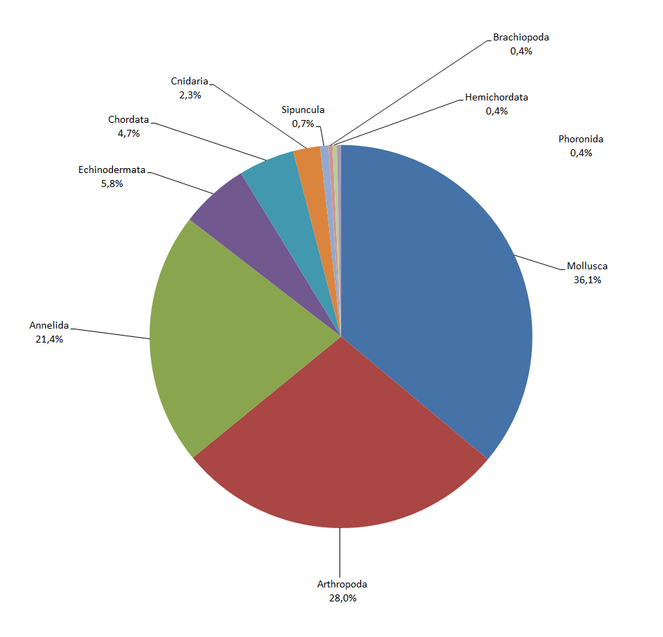
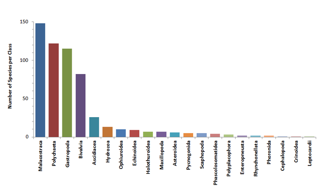
This set of historical data includes distribution information for 571 marine macrobenthic species belonging to 10 phyla, 21 classes and 257 families (Fig.
These macrofaunal species were distributed in 172 stations located in the marine area off Alexandria, Egypt (Table
| Scientific Name | Scientific Name accepted | Kingdom | Phylum | Class | Order | Family | Number of stations |
| Dentalium (Antalis) dentale forma inaequicostatum | Antalis inaequicostata | Animalia | Mollusca | Scaphopoda | Dentaliida | Dentaliidae | 41 |
| Branchiostoma lanceolatum | Branchiostoma lanceolatum | Animalia | Chordata | Leptocardii | Branchiostomatidae | 25 | |
| Chlamys glabra | Flexopecten glaber | Animalia | Mollusca | Bivalvia | Pectinida | Pectinidae | 21 |
| Pilumnus hirtellus | Pilumnus hirtellus | Animalia | Arthropoda | Malacostraca | Decapoda | Pilumnidae | 21 |
| Columbella rustica | Columbella rustica | Animalia | Mollusca | Gastropoda | Neogastropoda | Columbellidae | 19 |
| Abra ovata | Abra segmentum | Animalia | Mollusca | Bivalvia | Cardiida | Semelidae | 19 |
| Glycymeris pilosus var lineatus | Glycymeris bimaculata | Animalia | Mollusca | Bivalvia | Arcida | Glycymerididae | 19 |
| Beguina (Glans) trapezia | Glans trapezia | Animalia | Mollusca | Bivalvia | Carditida | Carditidae | 17 |
| Murex (Truncularia) trunculus | Hexaplex trunculus | Animalia | Mollusca | Gastropoda | Neogastropoda | Muricidae | 17 |
| Nassarius (Hinia) incrassatus | Tritia incrassata | Animalia | Mollusca | Gastropoda | Neogastropoda | Nassariidae | 17 |
| Rank | Scientific Name |
|---|---|
| phylum | Annelida |
| phylum | Mollusca |
| phylum | Arthropoda |
| class | Hydrozoa |
| phylum | Echinodermata |
| phylum | Sipuncula |
| class | Ascidiacea |
| phylum | Phoronida |
| phylum | Brachiopoda |
| class | Enteropneusta |
Temporal coverage
Sampling started at April 1st 1933 and ended at November 18th 1933.
Usage rights
Data resources
This publication consists of 12 individual datasets containing different taxonomic groups as published by the original authors between 1935 and 1940 and 2 metadata only (
| Column label | description |
| id | Same as eventID |
| type | The nature or genre of the resource (dataset etc) |
| eventID | An identifier for the sampling event (event=sampling that occurs at a place,time, specific protocol and depth) |
| parentEventID | An identifier for the broader Event at a specific station, that groups this and potentially other Events |
| samplingProtocol | The name of, reference to, or description of the method or protocol used during an Event |
| eventDate | The date-time or interval during which an Event occurred |
| year | The four-digit year in which the Event occurred, according to the Common Era Calendar |
| month | The original month in which the Event occurred |
| day | The original day in which the Event occurred |
| habitat | A category or description of the habitat in which the Event occurred |
| fieldNumber | The sample name |
| eventRemarks | Comments or notes about the Event |
| locationID | Station name |
| locality | The name or description of the place |
| minimumDepthInMeters | The lesser sampling depth of a range of depth below the local surface, in meters |
| maximumDepthInMeters | The greater sampling depth of a range of depth below the local surface, in meters |
| locationRemarks | Comments or notes about the station where the sample occurred |
| decimalLatitude | The geographic latitude (in decimal degrees) of the station |
| decimalLongitude | The geographic longitude (in decimal degrees) of the station |
| coordinateUncertaintyInMeters | The horizontal distance (in meters) from the given decimalLatitude and decimalLongitude describing the smallest circle containing the whole of the Location |
| Column label | description |
| id | Same as occurrenceID |
| type | The nature of the resource (e.g. dataset) |
| institutionCode | The name in use by the institution having custody of the object(s) or information referred to in the record |
| collectionCode | The name, coden, or initialism identifying the collection or data set from which the record was derived |
| basisOfRecord | The specific nature of the data record |
| occurrenceID | A unique identifier for the Occurrence |
| catalogNumber | An identifier for the record within the data set or collection |
| occurrenceRemarks | Comments or notes about the Occurrence |
| individualCount | The number of individuals represented present at the time of the Occurrence |
| sex | The sex of the biological individual(s) represented in the Occurrence |
| lifeStage | The age class or life stage of the biological individual(s) at the time the Occurrence was recorded |
| eventID | An identifier for the sampling event (event=sampling that occurs at a place,time, specific protocol and depth) |
| identifiedBy | A list of names of people, groups, or organizations who assigned the Taxon to the subject |
| identificationReferences | A list of references (publication, global unique identifier, URI) used in the Identification |
| scientificNameID | The lsid from WORMS |
| scientificName | The full scientific name. When forming part of an Identification, this should be the name in lowest level taxonomic rank that can be determined |
| kingdom | The full scientific name of the kingdom in which the taxon is classified |
| phylum | The full scientific name of the phylum or division in which the taxon is classified |
| class | The full scientific name of the class in which the taxon is classified |
| order | The full scientific name of the order in which the taxon is classified |
| family | The full scientific name of the family in which the taxon is classified |
| genus | The full scientific name of the genus in which the taxon is classified |
| subgenus | The full scientific name of the subgenus in which the taxon is classified. Values should include the genus to avoid homonym confusion |
| specificEpithet | The name of the first or species epithet of the scientificName |
| scientificNameAuthorship | The authorship information for the scientificName formatted according to the conventions of the applicable nomenclaturalCode |
| nomenclaturalCode | The nomenclatural code under which the scientificName is constructed |
| taxonRemarks | Comments or notes about the taxon or name |
| Column label | description |
| eventID | An identifier for the sampling event (event=sampling that occurs at a place, time, specific protocol and depth) |
| measurementID | An identifier for the MeasurementOrFact |
| measurementType | The nature of the measurement, fact, characteristic, or assertion |
| measurementValue | The value of the measurement, fact, characteristic, or assertion |
| measurementUnit | The units associated with the measurementValue |
| occurrenceID | A unique identifier for the Occurrence |
| measurementMethod | A description of or reference to (publication, URI) the method or protocol used to determine the measurement, fact, characteristic, or assertion |
| measurementDeterminedBy | A list of names of people, groups, or organizations who determined the value of the MeasurementOrFact |
| measurementTypeID | An identifier for the measurementType (global unique identifier, URI) |
| measurementAccuracy | The description of the potential error associated with the measurementValue |
| measurementRemarks | Comments or notes accompanying the MeasurementOrFact |
Additional information
Conclusions
Data rescue is an increasing need with expected effects on the scientific and societal perception of biodiversity. Despite the many challenges encountered during the digitization process of historical datasets (e.g. taxonomic updates, georeferencing, misspellings of taxa and places, compiling overlapping information from different publications), the outcome clearly shows that such initiatives are invaluable in making accessible previously unavailable biodiversity data.
Concerning the Egypt expedition, this paper is the first step for the digitization of the whole set of publications from "The fishery grounds near Alexandria". In Eastern Mediterranean, these data could be used to set the reference conditions for checking the invasion of alien species through the Suez Canal or to compare past species occurrences with current ones. In addition, the availability of these historical data through public databases (such as LifewatchGreece Research Infrastructure and MedOBIS) provides useful tools for present observations or monitoring potential change in benthic communities. Through virtual labs, scientists or other users could search, visualize on a map, combine and download species occurrences from all over the Mediterranean in several different formats.
Digitizing historical datasets offers also valuable information on functional species traits, as they usually contain individual characteristics, such as maturity and body length, and habitat characteristics, such as sediment type and vegetation. Information on functional species traits is required in describing species patterns and assessing future evolution of benthic communities.
Acknowledgements
This work was supported by the LifeWatchGreece infrastructure, funded by the Greek Government under the General Secretariat of Research and Technology (GSRT), ESFRI Projects, Structural Funds, OPCE II. The authors would like to thank Sarah Faulwetter for her invaluable assistance, training throughout the digitization process and manuscript revision and Christos Arvanitidis for comments on the manuscript. Thanks are also due to 2 reviewers hor helpful comments and critisism on the manuscript. Finally, we thank the European Marine Observation and Data Network – Biology (EMODnet Biology) WP4 partners for inspiration regarding data rescue.
Author contributions
I. Tsikopoulou and S. Nikolopoulou contributed equally to this work. I. Tsikopoulou, S. Nikolopoulou and A. Legaki were resource creators and content providers. P.D. Dimitriou and E. Avramidou were content providers. I. Tsikopoulou and S. Nikolopoulou wrote the first version of the manuscript. Nicolas Bailly has checked difficult taxonomic cases. All authors contributed to revisions.
References
- The importance of setting targets and reference conditions in assessing marine ecosystem quality.Ecological Indicators12(1):1‑7. https://doi.org/10.1016/j.ecolind.2011.06.018
- Biodiversity data should be published, cited, and peer reviewed.Trends in Ecology & Evolution28(8):454‑461. https://doi.org/10.1016/j.tree.2013.05.002
- Global Coordination and Standardisation in Marine Biodiversity through the World Register of Marine Species (WoRMS) and Related Databases.PLoS ONE8(1):e51629. https://doi.org/10.1371/journal.pone.0051629
- Les fonds de peche pres d'Alexandrie. XI Annelides Polychetes. Notes et Memoires No 19.Direction des Recherches des Pecheries,Egypt,62pp.
- General part. Zoological results of the Cambridge Expedition to the Suez Canal, 1924.Transact. Zool. Soc.,London,22pp.
- Rumsey D, Williams M (2002) Historical Maps in GIS. In: Knowles AK (Ed.) Past Time, Past Place: GIS for History.
- Report on the Danish Oceanographical Expeditions 1908-1910 on the Mediterranean and Adjacent Seas.Andr. Fred. Host & Son,Copenhagen,51pp.
- The fishery grounds near Alexandria. I. Preliminary report. Notes and Memoirs No 8.Fisheries Research Directorate,Egypt,24pp.
- The fishery grounds near Alexandria. XVIII Sipunculoidea, Phoronidea, Brachiopoda, Enteropneusta and Acrania. Notes and Memoirs No 33.Hydrobiology and Fisheries Directorate,Egypt,15pp.
- The fishery grounds near Alexandria. XIX Mollusca. Notes and Memoirs No 38.Hydrobiology and Fisheries Directorate,Egypt,152pp.
- The fishery grounds near Alexandria. II. A bottom sample taken at Alexandria. Notes and Memoirs No. 9.Fisheries Research Directorate,Egypt,4pp.
- The GBIF Integrated Publishing Toolkit User Manual, version 2.3.Copenhagen: Global Biodiversity Information Facility,57pp.
- World Register of Marine Species. http://www.marinespecies.org/aphia.php?p=match. Accessed on: 2016-7-19.
Supplementary material
Body length measurements are available for the following datasets:
1. EgyptExpeditionCumaceaStomatopodaLeptostacaea
2. EgyptExpeditionPolychaeta
3. EgyptExpeditionAmphipoda
4. EgyptExpeditionTanaidaceaIsopoda
5. EgyptExpeditionMollusca
Carapace length measurements are available for the dataset EgyptExpeditionDecapoda