|
Biodiversity Data Journal :
Data Paper (Biosciences)
|
|
Corresponding author: Frédéric Marchand (frederic.marchand@inra.fr)
Academic editor: Yasen Mutafchiev
Received: 17 Jul 2017 | Accepted: 03 Nov 2017 | Published: 09 Nov 2017
© 2017 Frédéric Marchand, Laurent Beaulaton, Etienne Prévost, Richard Delanoë, Jean-Pierre Destouches, François Gueraud, Yoann Guilloux, Nicolas Jeannot, Emmanuel Huchet, Frédéric Lange, Jacques Rives, Julien Tremblay, Nadine Herrard, Didier Azam
This is an open access article distributed under the terms of the Creative Commons Attribution License (CC BY 4.0), which permits unrestricted use, distribution, and reproduction in any medium, provided the original author and source are credited.
Citation:
Marchand F, Beaulaton L, Prévost E, Delanoë R, Destouches J, Gueraud F, Guilloux Y, Jeannot N, Huchet E, Lange F, Rives J, Tremblay J, Herrard N, Azam D (2017) Abundance indices and biological traits of juvenile salmon (Salmo salar) sampled in three rivers on the Atlantic and Channel coasts (France). Biodiversity Data Journal 5: e15125. https://doi.org/10.3897/BDJ.5.e15125
|
|
Abstract
Background
Atlantic Salmon (Salmo salar) is an anadromous migratory species adapted to cool temperatures. It is protected by the Bern convention and by the European Habitats Directive. It has been listed as vulnerable by the French IUCN Red List. Salmon decline is the result of combined and cumulated, mainly anthropic, causes: climate change, increasingly high number of impoundments, degradation of water quality and habitat and over-exploitation by fisheries. Monitoring of this species has been carried out on three rivers in France (Southern part of the distribution area) to produce data and knowledge (growth, precocious maturity, survival) for stock management.
For 24 years, a specific and standardised electric fishing protocol has been used to target young-of-the-year (0+ parr) Atlantic salmon. Sampling was restricted to areas with shallow running water that flows over a coarse bottom substrate, i.e. the preferred habitat of young salmon. This monitoring and inventory of growing areas thus allows assessment of juvenile recruitment and provides baseline data required to calculate total allowable catches (TACs).
New information
The dataset currently consists of 47,077 occurrence data points from 105 sites spanning up to 24 years in three different watersheds in France. Beyond our project, this dataset has a clear utility to research since it associates abundance measurements with the measurement of biological traits and the collection of tissue samples. It allows for current and retrospective characterisation of individuals or populations, according to life history traits and genetic features in relation to changes in environmental conditions. The fact that the monitoring takes place in France, the southern part of the distribution area, over 24 years, makes the dataset particularly relevant for climate change studies.
Keywords
abundance, biological traits, juvenile, coastal river, Salmo salar, salmon
Introduction
The Environmental Research Observatory (ERO) on Diadromous Fish in Coastal rivers (DiaPFC) is a research infrastructure focused on studying the evolution of diadromous fish populations under the influence of human-induced and environmental changes (mainly agriculture and climate). Currently, coastal rivers are the main refuge for diadromous fish that have disappeared or dramatically decreased in larger rivers (30,000 fish caught on the Loire-Allier system in the 1890s (
Project description
Environmental Research Observatory (ERO) on Diadromous Fish in Coastal rivers (DiaPFC): Abundance indices and biological traits of juvenile salmon (Salmo salar).
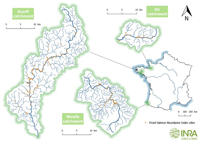
The Environmental Research Observatory (ERO) on Diadromous Fish in Coastal rivers (DiaPFC) monitors three coastal rivers on the Atlantic and Channel coasts of France: the Oir in Normandy, the Scorff in Brittany and the Nivelle in the French Basque Country (Fig.
Oir river: Latitude ranges from 48.6840 to 48.5985; longitude ranges from -1.2949 to -1.0994 and elevation range from 9 and 80 metres.
The Oir River is located on the southern edge of Normandy. It is a tributary of the Sélune, a coastal river that flows into the Bay of Mont Saint-Michel. The Oir is 21km long and has a mean gradient of 1.1%. Annual mean discharge is 1.1m3/s and the drainage basin area is 85.4km2. Geologically, the basin is dominated by sedimentary schist and metamorphic hornfels with granite inclusions. The water has nearly neutral pH and reasonably good quality except for high nitrate concentrations. Agriculture is the main human activity and land use. Migratory fish cannot access the upper Sélune because a dam 15km from the sea blocks their movement. The Oir, with 12km accessible to Atlantic salmon, is the main spawning ground and most productive tributary of the Sélune hydrographic network.
Scorff River: Latitude ranges from 47.7718 to 48.1682; longitude ranges from -3.2497 to -3.3404 and elevation range from 0 and 144 metres.
The Scorff River is a small coastal river in southern Brittany (France). The main river is 78.6km long, including a 15km estuary. The mean gradient is 3.6%, annual mean discharge is 5m3/s and the drainage basin area has an area of 480km2. Agriculture is the main human activity and land use, with several areas of moors and forests. Atlantic salmon essentially colonise only a 50km stretch of the main river starting at the head of the estuary. Most reproduction of Atlantic salmon occurs in the main river (
Nivelle River: Latitude ranges from 43.2426 to 43.3912; longitude ranges from -1.4799 to -1.6694 and elevation range from 6 and 75 metres.
The Nivelle River is a 39km long coastal river in the Basque Country. Its source lies in Spain and it flows into the Bay of Biscay at Saint-Jean-de-Luz. Its drainage basin has an area of 238km2, which is dominated by marly-calcareous formations. It is essentially agro-pastoral with more than 50% of the land area consisting of moors (
Rivers are equipped with diadromous fish trapping facilities and have been thoroughly and continually surveyed since the mid-1980s. They are affiliated with experimental ecology facilities located in Rennes (Brittany) and Saint-Pée-sur-Nivelle (Basque Country). To quantify their abundance of juvenile Atlantic salmon, they are surveyed every year in early autumn (late September to early October). The electric fishing protocol of
Sampling methods
In the Oir, sampling is conducted at 11 sites along the mainstream and 2 others on the 2 major tributaries (Fig.
Salmon Abundance Index is described in
- Two large dip-nets with semi circular metal frames, one 60cm wide and 40cm high and another 80cm wide and 40cm high with 4mm² mesh are placed facing the current, are rested on the bottom and are maintained in a fixed position. Dip-nets never varied over time.
- The area shocked is 4-5m directly upstream of the stationary dip nets so that fish disabled by the shocker are carried by the current into the dip nets.
- Fish attracted to the anode and shocked go down into the nets guided by the electrode and driven by the water flow. When necessary, a small hand net is used to catch fish stuck on the bottom or in aquatic vegetation.
- Individuals are transferred into a bucket previously filled with water.
- The entire team moves laterally several metres from the area that was recently disturbed by the electric field; the carrier of the electrofishing equipment is careful not to step into the area the anode will next explore . When a bank is reached, the team moves a few metres upstream.
Steps 1-5 are repeated. Sampling at a given site stops after 5 minutes of fishing, i.e. the duration during which the electric field is applied in the water, this being measured directly on the counter of the electrofishing equipment. Juvenile abundance is quantified by the number of individuals captured per unit effort (5 minutes of fishing under the conditions specified above).
Biometric measurements of the fish are recorded after anaesthetising specimens with a solution of benzocaïne (
Age is estimated by scale analysis according to standard methods described in
Data are stored in a PostgreSQL database and are thus subject to an integrity check by the database management system. Consistency checks, mainly on size and weight, were performed when the field records were entered. Since 2016, length and weight are automatically measured and sent by bluethooth to avoid transcription errors. All our weighing devices are checked annually and the tool length measurement is calibrated at the beginning of a fishing session.
Use of the French National Service for Water Data and Reference Dataset Management (SANDRE, Service d'administration nationale des données et référentiels sur l'eau) guarantees interoperability with French water information systems. The Sandre is organised in a network of SIE-contributing institutes that bring their thematic knowledge, participate in the reference data sets management and ensure the overall coherence. Managed by AFB, this network is supported by a technical secretariat provided by the International Office for Water, which moves, develops and makes available these reference data sets.
For publication on the GBIF portal, data and metadata were transformed to compliance with Darwin Core standards
Geographic coverage
Observations included in this dataset originate from three coastal rivers on the Atlantic and Channel coasts of France: the Oir in Normandy, the Scorff in Brittany and the Nivelle in the Basque Country (Fig.
43.2426 and 48.6840 Latitude; -1.0994 and -3.3404 Longitude.
Taxonomic coverage
Fundamental features of the specie's life cycle, distribution and ecology can be found in Les poissons d’eau douce de France (
| Rank | Scientific Name | Common Name |
|---|---|---|
| kingdom | Animalia | |
| phylum | Chordata | |
| class | Actinopterygii | |
| order | Salmoniformes | |
| family | Salmonidae | |
| species | Salmo salar (Linnaeus, 1758) | Atlantic salmon |
Temporal coverage
Field sampling and data collection have been conducted annually in September or October since 1993 for the Oir and Scorff and since 2003 for the Nivelle (Suppl. material
Collection data
Usage rights
Data resources
The dataset consists of two types of data:
- Sampling events, describing the protocol, date and capture location, which can be common to several captures. Events with no catch are also recorded and Occurrences associated with these events.
- Measurement or fact describing characteristics of each individual.
| Column label | Column description |
|---|---|
| ID | Identifier of the occurence (GBIF) |
| institutionCode | The acronym in use by the institution having custody of data |
| collectionCode | The name identifying the data set from which the record was derived |
| ownerInstitutionCode | Institution having ownership of the data |
| basisOfRecord | The specific nature of the data record |
| occurrenceID | Identifier of the occurrence (INRA) |
| organismQuantity | Number of organism for the occurenceID |
| organismQuantityType | Type of quantification system used for the quantity of organisms |
| sex | Sex of the individual corresponding to the occurrence when it is possible (mainly male if it had a soft and distended underbelly from enlarged gonads or produced milt when massaged gently) |
| establishmentMeans | The process by which the biological individual(s) represented in the Occurrence became established at the location ("native", "cultivated",...) |
| occurrenceStatus | A statement about the presence or absence of a Taxon at a Location |
| eventID | Identifier of the event |
| samplingProtocol | Name of the protocol used during the event Name of the protocol used during the event |
| sampleSizeValue | Numeric value for the samplingEffort |
| sampleSizeUnit | The unit of measurement of the samplingEffort |
| samplingEffort | The amount of effort expended during an Event |
| eventDate | Date the event was recorded (aaaa-mm-dd) |
| locationID | Identifier for the location in which the event occurred |
| waterBody | Name of the water body in which the event occurred |
| country | Name of the country in which the event occurred |
| countryCode | Code of the country in which the event occurred |
| minimumElevationInMeters | Minimum elevation in metres |
| maximumElevationInMeters | Maximum elevation in metres |
| decimalLatitude | Geographic latitude |
| decimalLongitude | Geographic longitude |
| geodeticDatum | Spatial reference system |
| scientificName | Full scientific name of the species corresponding to the occurrence |
| kingdom | The full scientific name of the kingdom in which the taxon is classified |
| phylum | The full scientific name of the phylum in which the taxon is classified |
| class | The full scientific name of the class in which the taxon is classified |
| order | The full scientific name of the order in which the taxon is classified |
| family | The full scientific name of the family in which the taxon is classified |
| taxonRank | The taxonomic rank of the most specific name in the scientificName |
| measurementType | The nature of the measurement (length, weight, age, maturity, scales sampled, fin tissue sampled and number of associated occurences in the locationID) |
| measurementValue | The value of the measurement |
| measurementUnit | The units associated with the measurementValue |
The dataset consists of two types of data:
- Sampling events, describing the protocol, date and capture location, which can be common to several captures. Events with no catch are also recorded and Occurrences associated with these events.
- Measurement or fact describing characteristics of each individual.
| Column label | Column description |
|---|---|
| ID | Identifier of the occurence (GBIF) |
| institutionCode | The acronym in use by the institution having custody of data |
| collectionCode | The name identifying the data set from which the record was derived |
| ownerInstitutionCode | Institution having ownership of the data |
| basisOfRecord | The specific nature of the data record |
| occurrenceID | Identifier of the occurrence (INRA) |
| organismQuantity | Number of organism for the occurenceID |
| organismQuantityType | Type of quantification system used for the quantity of organisms |
| sex | Sex of the individual corresponding to the occurrence when it is possible (mainly male if it had a soft and distended underbelly from enlarged gonads or produced milt when massaged gently) |
| establishmentMeans | The process by which the biological individual(s) represented in the Occurrence became established at the location ("native", "cultivated",...) |
| occurrenceStatus | A statement about the presence or absence of a Taxon at a Location |
| eventID | Identifier of the event |
| samplingProtocol | Name of the protocol used during the event Name of the protocol used during the event |
| sampleSizeValue | Numeric value for the samplingEffort |
| sampleSizeUnit | The unit of measurement of the samplingEffort |
| samplingEffort | The amount of effort expended during an Event |
| eventDate | Date the event was recorded (aaaa-mm-dd) |
| locationID | Identifier for the location in which the event occurred |
| waterBody | Name of the water body in which the event occurred |
| country | Name of the country in which the event occurred |
| countryCode | Code of the country in which the event occurred |
| minimumElevationInMeters | Minimum elevation in metres |
| maximumElevationInMeters | Maximum elevation in metres |
| decimalLatitude | Geographic latitude |
| decimalLongitude | Geographic longitude |
| geodeticDatum | Spatial reference system |
| scientificName | The full scientific name of the class in which the taxon is classified |
| kingdom | The full scientific name of the kingdom in which the taxon is classified |
| phylum | The full scientific name of the phylum in which the taxon is classified |
| class | The full scientific name of the class in which the taxon is classified |
| order | The full scientific name of the order in which the taxon is classified |
| family | The full scientific name of the family in which the taxon is classified |
| taxonRank | The taxonomic rank of the most specific name in the scientificName |
| measurementType | The nature of the measurement (length, weight, age, maturity, scales sampled, fin tissue sampled and number of associated occurences in the locationID) |
| measurementValue | The value of the measurement |
| measurementUnit | The units associated with the measurementValue |
The dataset consists of two types of data:
- Sampling events, describing the protocol, date and capture location, which can be common to several captures. Events with no catch are also recorded and Occurrences associated with these events.
- Measurement or fact describing characteristics of each individual.
| Column label | Column description |
|---|---|
| ID | Identifier of the occurence (GBIF) |
| institutionCode | The acronym in use by the institution having custody of data |
| collectionCode | The name identifying the data set from which the record was derived |
| ownerInstitutionCode | Institution having ownership of the data |
| basisOfRecord | The specific nature of the data record |
| occurrenceID | Identifier of the occurrence (INRA) |
| organismQuantity | Number of organism for the occurenceID |
| organismQuantityType | Type of quantification system used for the quantity of organisms |
| sex | Sex of the individual corresponding to the occurrence when it is possible (mainly male if it had a soft and distended underbelly from enlarged gonads or produced milt when massaged gently) |
| establishmentMeans | The process by which the biological individual(s) represented in the Occurrence became established at the location ("native", "cultivated",...) |
| occurrenceStatus | A statement about the presence or absence of a Taxon at a Location |
| eventID | Identifier of the event |
| samplingProtocol | Name of the protocol used during the event Name of the protocol used during the event |
| sampleSizeValue | Numeric value for the samplingEffort |
| sampleSizeUnit | The unit of measurement of the samplingEffort |
| samplingEffort | The amount of effort expended during an Event |
| eventDate | Date the event was recorded (aaaa-mm-dd) |
| locationID | Identifier for the location in which the event occurred |
| waterBody | Name of the water body in which the event occurred |
| country | Name of the country in which the event occurred |
| countryCode | Code of the country in which the event occurred |
| minimumElevationInMeters | Minimum elevation in metres |
| maximumElevationInMeters | Maximum elevation in metres |
| decimalLatitude | Geographic latitude |
| decimalLongitude | Geographic longitude |
| geodeticDatum | Spatial reference system |
| Spatial reference system | Full scientific name of the species corresponding to the occurrence |
| kingdom | The full scientific name of the kingdom in which the taxon is classified |
| phylum | The full scientific name of the phylum in which the taxon is classified |
| class | The full scientific name of the class in which the taxon is classified |
| order | The full scientific name of the order in which the taxon is classified |
| family | The full scientific name of the family in which the taxon is classified |
| taxonRank | The taxonomic rank of the most specific name in the scientific Name |
| measurementType | The nature of the measurement (length, weight, age, maturity, scales sampled, fin tissue sampled and number of associated occurences in the locationID) |
| measurementValue | The value of the measurement |
| measurementUnit | The units associated with the measurementValue |
Additional information
These datasets are intended to be updated annually. A new DOI should be attributed to each update.
All monitoring activities of the ERO DiaPFC are submitted to and accepted by an animal ethics committee.
Acknowledgements
We thank U3E, UMR ECOBIOP, UMR ESE, AFB and FDPPMA56 staff for their valuable help in collecting data and biological samples and GBIF for publishing data.
References
- L’histoire du saumon en loire.Bulletin Francais de Pisciculture211‑49–70.
- La fraie du saumon atlantique (Salmo salar L.) et de la truite commune (Salmo trutta L.) sur le bassin du Scorff.Cybium3(7):75‑96.
- Caractéristiques scalimétriques des principales espèces de poissons d'eau douce de France.Bulletin Français de la Pêche et de la Pisciculture1‑39. https://doi.org/10.1051/kmae:1987005
- La détermination de l'âge par scalimétrie chez le saumon atlantique (Salmo salar) dans son aire de répartition méridionale : utilisation pratique et difficultés de la méthode.Bulletin Français de la Pêche et de la Pisciculture69‑105. https://doi.org/10.1051/kmae:1985002
- Bal G (2011) Evolution des populations française de saumon atlantique (Salmo salar L.) et changement climatique.UMR ESE INRA Agrocampus Ouest. Thèse, Université de Rennes
- Assessing adaptive phenotypic plasticity by means of conditional strategies from empirical data: the latent environmental threshold model.Evolution66(4):996‑1009. https://doi.org/10.1111/j.1558-5646.2011.01484.x
- Investigating evolutionary trade-offs in wild populations of atlantic salmon (Salmo salar): incorporating detection probabilities and individual heterogeneity: estimating trade-offs with mark-recapture data.Evolution64(9):2629‑2642. https://doi.org/10.1111/j.1558-5646.2010.01029.x
- Variability of demographic parameters and population dynamics of Atlantic salmon Salmo salar L. in a south-west French river.ICES Journal of Marine Science60(2):356‑370. https://doi.org/10.1016/S1054-3139(03)00003-1
- Efficacy of benzocaine as an anesthetic for Sahnonid Fishes.North American Journal of Fisheries Management9(2):150‑153. https://doi.org/10.1577/1548-8675(1989)009<0150:EOBAAA>2.3.CO;2
- Patterns on a parr: Drivers of long-term salmon parr length in U.K. and French rivers depend on geographical scale.Freshwater Biologyhttps://doi.org/10.1111/fwb.12929
- Les poissons d'eau douce de France.Collection Inventaires et biodiversité.Muséum National d'Histoire Naturelle,Paris,552pp.
- Fish sedation, analgesia, anesthesia, and euthanasia: considerations, methods, and types of drugs.ILAR journal50(4):343‑360.
- Contrasting effects of climate change in continental vs. oceanic environments on population persistence and microevolution of Atlantic salmon.Global Change Biology19(3):711‑723. https://doi.org/10.1111/gcb.12085
- Prévost E, Baglinière JL (1995) Présentation et premiers éléments de mise au point d'une méthode simple d'évaluation en eau courante, du recrutement en juvéniles de saumon atlantique (Salmo salar) de l'année. Les recherches françaises en évaluation quantitative et modélisation des ressources et des systèmes halieutiques: actes du colloque. URL: http://www.documentation.ird.fr/hor/fdi:42111 [ISBN2-7099-1259-7].
- Description et interprétation des écailles de truites de mer (Salmo trutta L.) de deux rivières de Basse-Normandie: l'Orne et la Touques.Bulletin Français de la Pêche et de la Pisciculture239‑257. https://doi.org/10.1051/kmae:1990008
- Hierarchical Bayesian analysis of capture-mark-recapture data.Canadian Journal of Fisheries and Aquatic Sciences59(11):1768‑1784. https://doi.org/10.1139/f02-145
- Stable isotope analyses on archived fish scales reveal the long-term effect of nitrogen loads on carbon cycling in rivers.Global Change Biology20(2):523‑530. https://doi.org/10.1111/gcb.12293
- Darwin Core: an volving community-developed biodiversity data standard.PLoS ONE7(1):e29715. https://doi.org/10.1371/journal.pone.0029715