|
Biodiversity Data Journal :
Data Paper (Biosciences)
|
|
Corresponding author: Takeshi Osawa (arosawa@gmail.com)
Academic editor: Yasen Mutafchiev
Received: 28 Sep 2017 | Accepted: 01 Nov 2017 | Published: 06 Nov 2017
© 2017 Takeshi Osawa, Takehiko Yamanaka, Yukinobu Nakatani, Jun Nishihiro, Shiori Takahashi, Suzuki Mahoro, Hironobu Sasaki
This is an open access article distributed under the terms of the Creative Commons Attribution License (CC BY 4.0), which permits unrestricted use, distribution, and reproduction in any medium, provided the original author and source are credited.
Citation:
Osawa T, Yamanaka T, Nakatani Y, Nishihiro J, Takahashi S, Mahoro S, Sasaki H (2017) A crowdsourcing approach to collecting photo-based insect and plant observation records. Biodiversity Data Journal 5: e21271. https://doi.org/10.3897/BDJ.5.e21271
|
|
Abstract
Background
Scientific field observation by members of the public is known as citizen science and has become popular all across the world. Citizen science is advantageous for collecting large amounts of scientific data and can be seen as a crowdsourcing approach to data collection. Information and communications technology is enhancing the availability of citizen science. Mobile devices, such as mobile phones, that have a digital camera with a global positioning system (GPS) are necessities for contemporary life and can be utilised as powerful observation tools in citizen science.
New information
A web-based system has been developed as a data collection tool for citizen science. Participants submit an e-mail with a photo taken by their mobile phones. The photos contain location information, which can be easily and automatically embedded if the mobile phone is equipped with GPS. Collaboration has been undertaken with regional event managers, such as museum curators and held citizen science events in each region and for various target taxonomic groups. All photos were stored in the data server and the organisms were taxonomically identified by citizen scientists, regional managers and the authors. In total, 154 species and 843 data records were collected in this project conducted from 2011 to 2016.
Keywords
Citizen science; Mobile phone; Social networking system; Open data
Introduction
A citizen scientist is a volunteer who collects or processes data as part of a scientific enquiry (
Recent advances in information and communications technology have made citizen science more user-friendly and accessible (
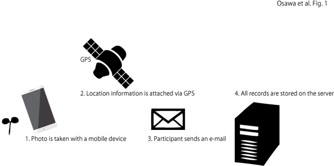
A web-based system has been developed as a data collection tool for citizen science. When a participant submits an e-mail with a photo that has embedded GPS information, the system automatically detects when and where the observation was made from the exchangeable image file format (EXIF) information and these data are stored in the system’s data server. Collaboration is undertaken with regional event managers such as teachers and museum curators and field observation events conducted with citizen scientists using our web-based system (
In this data paper, the collection of both plant and insect observation records are reported based on photos taken by many citizen scientists. All records have the location and date/time, which were extracted from the EXIF information in the header of the photo files. Although observation records, collected by citizen scientists, may have quality problems, such as misidentification (
Project description
NIAES mobile photo project
This project does not have specific themes, such as target species. Instead, the themes are chosen by regional project managers, who have their own targets, motivations and purposes. Thus, the project was designed to include a variety of approaches, have different goals and involve many scientific disciplines (
The platform has been provided (described in the Sampling methods section) for an internet-based photo-collection system for regional managers. Regional managers have been assisted in arranging data collection events, but the data collection itself is handled by the regional managers. For example, the manager could be a natural history museum curator who is interested in organising nature walks that incorporate photography, or an environmental non-profit organisation that is conducting a survey of alien invasive species around a locality. Each regional manager arranges the data collection method, recruits participants and posts photos to this system via e-mail. Those e-mails are then automatically handled by the system and are stored in the system’s data server.
Sampling methods
A web-based system has been developed to collect photos taken by citizen scientists. The system is a customised version of the commercial mobile photo system developed by Fujitsu FIP, Co. (http://www.fujitsu.com/jp/group/fip/solutions/business-and-technology-solutions/sustainability-solution/management/biodiversity/; accessed 10 August 2017). Customised system could set a several subsystem which independent in each. Each regional manager can prepare that system according to the purpose of the collection event and manage it. In the subsystem, the regional manager can manage the photos which are collected for their event only. In the main system which is managed by the authors, all photos are collected by all subsystems. The data collection procedure is simple: a participant takes a photo of the observation target and sends an e-mail with the photo that has geographic information embedded by GPS (Fig.
The rationale for each event are discussed with the regional manager beforehand and an event-specific subsystem for projects is established. An event-specific address to which the participants send their e-mails is designated. Event-specific websites which relate to each subsystem are opened. For some observation events, citizen scientists are asked to identify the organisms that they have observed and put the names of the organisms in their e-mails. Regional managers are helped to check all records posted and re-examine the species names classified by the citizen scientists on the basis of the photos attached. Records that could not be identified to the species level from a photo are removed.
Geographic coverage
The collection sites of the data provided here are distributed across Japan, from Hokkaido to the southern islands. One foreign record is also included.
; .
Taxonomic coverage
With regard to taxonomy and systematics, all species were identified by the regional managers and authors according to the morphotypes of objects. If sufficient information could not be obtained for proper species identification, i.e. the species which is difficult to identify, that record was not included in this data paper. As a result, 843 records of 154 species have been provided. Thus, these species were ordinary which can identify easily based on photo.
Temporal coverage
The system was launched in 2011. Data will be released from 2011 to 2016.
Usage rights
Data resources
The data set is available from GBIF network through Japan node of GBIF(JBIF).
| Column label | Column description |
|---|---|
| occurrenceID | An identifier for the Occurrence (photo). |
| institutionID | An identifier for the institution having custody of the information. |
| collectionCode | Identifying the collection from which the record was derived. In this data set, project name is provided. |
| basisOfRecord | The specific nature of the data record. In this data set, all records were "Observation". |
| scientificName | The scientific name without authors and year. |
| taxonRank | Lowest taxonomic rank of the record. In this data set, all records were species. |
| kingdom | Kingdom name. |
| phylum | Phylum name. Some of species were not ranked. |
| class | Class name. Some of species were not ranked. |
| order | Order name. |
| family | Family name. |
| eventDate | The date on which a photo was taken. |
| decimalLatitude | Approximate point latitude of the field site in decimal degrees. |
| decimalLongitude | Approximate point longitude of the field site in decimal degrees. |
| verbatimCoordinateSystem | The spatial coordinate system on that data set. |
| geodeticDatum | Geodetic datum |
Acknowledgements
This study was supported by JSPS KAKENHI grants no. 15K12154 and no. 24651040.
References
- Citizen science as an ecological research tool: challenges and benefits.Annual Review of Ecology, Evolution, and Systematics41(1):149‑172. https://doi.org/10.1146/annurev-ecolsys-102209-144636
- The current state of citizen science as a tool for ecological research and public engagement.Frontiers in Ecology and the Environment10(6):291‑297. https://doi.org/10.1890/110236
- Citizen science: a new approach to advance ecology, education, and conservation.Ecological Research31(1):1‑19. https://doi.org/10.1007/s11284-015-1314-y
- Adding fish images taken in other countries to the biodiversity database of a Japanese public museum, with report of range extension of Labrisomus jenkinsi from the Pacific coast of Costa Rica.Ecological Research32(1):89‑93. https://doi.org/10.1007/s11284-016-1409-0
- Biological monitoring by citizens using Web-based photographic databases of fishes.Biodiversity and Conservation23(9):2383‑2391. https://doi.org/10.1007/s10531-014-0724-4
- Monitoring records of plant species in the Hakone region of Fuji-Hakone-Izu National Park, Japan, 2001–2010.Ecological Research28(4):541‑541. https://doi.org/10.1007/s11284-013-1049-6
- Importance of farmland in urbanized areas as a landscape component for barn swallows (Hirundo rustica) nesting on concrete buildings.Environmental Management55(5):1160‑1167. https://doi.org/10.1007/s00267-015-0457-5
- Establishing a canonical procedure for collecting biodiversity information from citizen scientists using mobile phones.Japanese Journal of Conservation Ecology18:157‑165. [InJapanese]. https://doi.org/10.18960/hozen.18.2_157
- Redefining ‘citizen science’ from several perspectives.Japanese Journal of Conservation Ecology21:243‑248. [InJapanese]. https://doi.org/10.18960/hozen.21.2_243
- A new dawn for citizen science.Trends in Ecology & Evolution24(9):467‑471. https://doi.org/10.1016/j.tree.2009.03.017
- eBird: A citizen-based bird observation network in the biological sciences.Biological Conservation142(10):2282‑2292. https://doi.org/10.1016/j.biocon.2009.05.006