|
Biodiversity Data Journal :
Data Paper (Biosciences)
|
|
Corresponding author: Anders Bryn (anders.bryn@nibio.no)
Academic editor: Quentin Groom
Received: 06 Nov 2017 | Accepted: 18 Nov 2017 | Published: 23 Nov 2017
© 2017 Anders Bryn, Kerstin Potthoff
This is an open access article distributed under the terms of the Creative Commons Attribution License (CC BY 4.0), which permits unrestricted use, distribution, and reproduction in any medium, provided the original author and source are credited.
Citation:
Bryn A, Potthoff K (2017) 20th century Betula pubescens subsp. czerepanovii tree- and forest lines in Norway. Biodiversity Data Journal 5: e22093. https://doi.org/10.3897/BDJ.5.e22093
|
|
Abstract
Background
Georeferenced tree- and forest line data has a wide range of applications and are increasingly used for e.g. monitoring of climate change impacts and range shift modelling. As part of a research project, registrations of previously re-mapped tree- and forest lines have been georeferenced. The data described in this paper contains 100 re-mapped registrations of Betula pubescens subsp. czerepanovii throughout Norway. All of the re-mapped tree- and forest line localities are georeferenced, elevation and aspect are given, elevational and spatial uncertainty are provided, and the re-mapping methods are explained. The published data weremapped for the first time between 1819 and 1963. The same sites were re-mapped between 1928 and 1996, but have until now been missing spatial coordinates. The entries contain 40 x 2 tree lines and 60 x 2 forest lines, most likely presenting the regionally highest registered tree- and forest lines at the given time. The entire material is stored and available for download through the GBIF server.
New information
Previously, the entries have been published in journals or reports, partly in Norwegian or German only. Without the provision of the spatial coordinates, the specific locations have been unknown. The material is now available for modelling and monitoring of tree- and forest line range shifts: The recordings are useful for interpretation of climate change impacts on tree- and forest lines, and the locations of re-mapped tree- and forest lines can be implemented in future monitoring projects. Since the recordings most likely provide the highest registered Betula pubescens subsp. czerepanovii locations within their specific regions, they are probably representing the contemporary physiognomic range limits.
Keywords
elevation, mountain birch, range limit, re-mapping, spatial coordinates, treeline
Introduction
The last century of global warming affects the world’s vegetation, particularly in cold temperature-limited ecosystems (e.g.
General description
The purpose of making re-mapped and georeferenced data of TFLs available was to enable the data's potential for spatiotemporal analyses of TFL dynamics. Specifically the goals were to identify the localities, georeference them, and through GBIF publish re-mapped TFL locations of Betula pubescens subsp. czerepanovii from Norway.
The data described in this article contains 100 georeferenced entries of re-mapped TFLs of Betula pubescens subsp. czerepanovii. The data contains registrations of elevation from two periods, a first registry and a second re-mapped registry from the same site. Each entry consists of re-mapped TFL localities that are georeferenced. The elevation and exposition is given for both records. Elevational and spatial uncertainty is provided for all entries, and the re-mapping methods are explained. The entries have recently been published (18 October 2017) on the GBIF-server, they are stored there, and are available for download.
Sampling methods
The study extent includes mainland Norway.
The TFLs have originally been re-sampled in six different ways (Table
Reference to original author and number of entries of tree- and forest lines.
|
Original author (reference) |
Tree lines |
Forest lines |
Re-sampling method |
|
|
0 |
3 |
In-situ re-mapping (1), photo comparison (1) and map comparison (1) |
|
|
0 |
5 |
In-situ re-mapping (4) and map comparison (1) |
|
|
36 |
25 |
In-situ re-mapping |
|
|
2 |
7 |
In-situ re-mapping |
|
|
0 |
1 |
Oral information |
|
|
0 |
2 |
In-situ re-mapping |
|
|
0 |
2 |
In-situ re-mapping |
|
|
0 |
8 |
Comparison of empiric and climatic forest |
|
|
2 |
7 |
Comparison of old and young forests |
|
Total |
40 |
60 |
The TFL locations which have been georeferenced, were spatially located through three steps using GIS (ArcGIS v. 10.3). First, the locality names provided by the authors were used to locate sites based on a query in the standard Norwegian topographic maps (
The georeferenced locations have two main potential sources of uncertainty: i) the uncertainty given by the original authors regarding the measurements of elevation and ii) the uncertainty regarding the exact spatial position along the combination of aspect and elevation.
The uncertainties have been reported in two ways: i) The altitudinal uncertainty (expected precision) has been divided into three categorical classes: high precision (± 5 m a.s.l.) reflects standard GPS quality, intermediate precision (± 10 m a.s.l.) reflects in-situ measurements using barometer, and comparisons of empirical and climatic forest lines, whereas low precision (± 25 m a.s.l.) reflects comparisons of old and young forest lines, comparison with old photo, map comparison, or where authors have reported uncertain measurements of elevation. ii) The uncertainty regarding coordinate precision has been reported as a vector length combining aspect and elevation at the sites. This uncertainty ranges between 160 and 5200 m, with an average of 1113 m.
All re-sampled records have been checked with aerial photos, and 76 of the locations (76 %) have been visited during field-work from 2013 to 2017. The oldest re-sampled records are more or less impossible to validate, since they are older than all available aerial photos and precise maps, and since most trees from that period are dead and lost through decomposition.
Twenty potential records have not been registered. Ten records were average numbers, and did not represent single locations, whereas the other ten records only showed the elevational change and not the elevation at the locations.
Geographic coverage
The TFLs have been re-sampled in the main mountain regions of Norway, but some regions have far more entries than others (Fig.
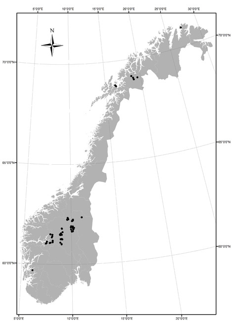
57°58'50'' and 71°11'8'' Latitude; 4°49'8'' and 31°3'26'' Longitude.
Taxonomic coverage
This dataset includes occurrence data from 1 species, mountain birch (Betula pubescens subsp. czerepanovii). There are two common synonyms, namely Betula pubescens subsp. tortuosa (Ledeb.) Nyman, and Betula pubescens var. pumila (L.) Govaerts. Misidentification of mountain birch (Betula pubescens subsp. czerepanovii), at the highest elevated locations, is highly unlikely. This is because it is the only known tree-forming birch species present at the boreal-alpine ecotone in Norway. In GBIF, the higher nomenclature was added to all records, from Kingdom to Subspecies.
Traits coverage
The entries include mountain birches tall enough to be defined as trees following the definitions of the original authors (Table 1). It is thus the location of a physiognomic plant unit that has been georeferenced.
Temporal coverage
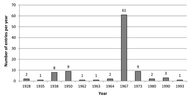
The data havebeen re-sampled from 1928 to 1996, varying in number from 1 entry in the years 1935, 1962, 1963 and 1993 to 61 entries in 1967 (Fig.
Usage rights
Data resources
Occurences of re-sampled tree- and forest lines in Norway. The dataset consists of Darwin Core Attributes.
| Column label | Column description |
|---|---|
| occurrenceID | An identifier for the occurrence |
| eventID | An identifier for the record (record code) |
| parentEventID | An identifier for the pairs of re-sampled occurrences (grouping of events) |
| organismID | An identifier for the organism instance |
| dcterms:modified | The most recent date-time on which the resource was changed |
| institutionCode | The acronym of the institution providing the record |
| datasetName | The name identifying the data set from which the record was derived |
| scientificName | The full scientific species name, including authorship information |
| basisOfrecord | The specific nature of the data record |
| kingdom | The full scientific name of the kingdom in which the taxon is classified |
| phylum | The full scientific name of the phylum in which the taxon is classified |
| class | The full scientific name of the class in which the taxon is classified |
| order | The full scientific name of the order in which the taxon is classified |
| family | The full scientific name of the family in which the taxon is classified |
| genus | The full scientific name of the genus in which the taxon is classified |
| specificEpithet | The name of the species epithet of the scientificName |
| infraspecificEpithet | The name of the terminal infraspecific epithet of the scientificName, excluding any rank designation |
| scientificNameAuthorship | The authorship information for the scientificName formatted according to the conventions of the applicable nomenclaturalCode |
| recordedBy | Names of the person(s) who has recorded data |
| year | The four-digit year in which the Event occurred, according to the Common Era Calendar |
| month | The ordinal month in which the Event occurred |
| country | The name of the country in which the location occurs |
| stateProvince | The name of the county in which the data werecollected |
| locality | The specific name of the locality |
| verbatimLongitude | The verbatim original longitude of the location |
| verbatimLatitude | The verbatim original latitude of the location |
| verbatimCoordinateSystem | The spatial coordinate system for the verbatimLatitude and verbatimLongitude |
| decimalLongitude | The geographic longitude (in decimal degrees, using the spatial reference system given in geodeticDatum) of the geographic center of a location |
| decimalLatitude | The geographic longitude (in decimal degrees, using the spatial reference system given in geodeticDatum) of the geographic center of a location |
| geodeticDatum | The ellipsoid, geodetic datum, or spatial reference system (SRS) upon which the geographic coordinates given in decimalLatitude and decimalLongitude as based |
| coordinateUncertaintyInMeters | The coordinate uncertainty of the specific locality given in meters |
| georeferencedBy | Names of those who determined the georeference (spatial representation) for the location |
| verbatimElevation | The original description of the elevation (altitude above sea level) of the location, in meters |
| minimumElevationInMeters | The lower limit of the range of elevation (altitude above sea level) of the location, in meters |
| maximumElevationInMeters | The higher limit of the range of elevation (altitude above sea level) of the location, in meters |
| associatedReferences | Reference to the original literature associated with the occurrence |
| dynamicProperties | Aspect of the locality given as categories (E, SE, S, SW, W, NW, N, NE) |
| eventRemarks | Provides a record of the two physiognomic units that were measured at the location; tree line or forest line |
| samplingProtocol | A short name describing the method for re-sampling tree- and forest lines |
| eventRemarks | Specific comment regarding uncertainty or method |
| samplingProtocol | A short name describing the type of physiognomic range limit (single highest or lowest) |
Acknowledgements
The authors would like to thank Dag Endresen and Christian Svindseth at GBIF Oslo, Peter Horvath for help during field-work, two anonymous reviewers for their comments on the manuscript, and all authors of the publications from which we have georeferenced entries.
Author contributions
Both authors have contributed equally.
References
- Climatically raised birch lines in Southeastern Norway 1918-1968.Norsk Geografisk Tidsskrift23(3):119‑130. https://doi.org/10.1080/00291956908542805
- Skoggrenseutviklingen i Norge, særlig i det 20. århundre.AmS-Varia24:89‑100. [InNorwegian].
- Aas B, Faarlund T (1996) The present and the Holocene subalpine birch belt in Norway. In: Frenzel B (Ed.) Holocene treeline oscillations, dendrochronology and palaeoclimate.Gustav Fischer Verlag,Stuttgart,19-42pp. [ISBN3437253867].
- Axelsen BJ (1975) Ressursutnyttelse i et fjellområde. Seterfjellet i Øystre Slidre - Utnyttelse av og påvirking på naturgrunnlaget.University of Oslo,Oslo. [InNorwegian].
- Step-less models for regional environmental variation in Norway.Journal of Biogeography35(10):1906‑1922. https://doi.org/10.1111/j.1365-2699.2008.01941.x
- Drivers of treeline shift in different European mountains.Climate Research73:135‑150. https://doi.org/10.3354/cr01465
- Die Waldgrenzen auf der Haugesund-Halbinsel im westlichen Norwegen.Det Norske Videnskaps-Akademi i Oslo,Oslo. [InGerman].
- Latitudinal forest advance in northernmost Norway since the early 20th century.Journal of Biogeography40(5):938‑949. https://doi.org/10.1111/jbi.12053
- Mountain Timberlines: Ecology, Patchiness, and Dynamics.2nd Edition.Springer Netherlands,438pp. https://doi.org/10.1007/978-1-4020-9705-8
- Increased plant biomass in a High Arctic heath community from 1981 to 2008.Ecology90(10):2657‑2663. https://doi.org/10.1890/09-0102.1
- Alpine Treeline. Functional Ecology of the Global High Elevation Tree Limits.Springer Verlag,Basel. [ISBN978-3-0348-0395-3]
- The N50 topographic map series of Norway. Scale 1:50.000.Norwegian Mapping Authority,Hønesfoss. [InNorwegian].
- Recent plant diversity changes on Europe's mountain summits.Science336(6079):353‑355. https://doi.org/10.1126/science.1219033
- Do shifting forest limits in south-west Norway keep up with climate change?Scandinavian Journal of Forest Research28(6):574‑580. https://doi.org/10.1080/02827581.2013.793776
- Vettismorki. Monografi over et skogområde. Meldinger fra Norges Landbrukshøgskole 43.Norges Landbrukshøgskole,Ås. [InNorwegian].
- Skogtrærnes forekomst og høidegrenser i Årdal. Plantegeografiske og bygdehistoriske studier.A.S. John Griegs Boktrykkeri,Bergen. [InNorwegian].
- Skog og treslag i Indre Sogn frå Lærdal til Fillefjell. Med ei utgreiding um gran i Sogn.Vestlandets forstlige forsøksstation,Bergen. [InNorwegian].
- Ve S (1951) Stig skoggrensa? Tidsskrift for skogbruk.59.305-317pp. [InNorwegian].