|
Biodiversity Data Journal :
Data Paper (Biosciences)
|
|
Corresponding author: Kevin R. Burgio (kevin.burgio@uconn.edu)
Academic editor: Ross Mounce
Received: 26 Mar 2018 | Accepted: 12 Jun 2018 | Published: 19 Jun 2018
© 2018 Kevin Burgio, Colin Carlson, Alexander Bond
This is an open access article distributed under the terms of the Creative Commons Attribution License (CC BY 4.0), which permits unrestricted use, distribution, and reproduction in any medium, provided the original author and source are credited.
Citation:
Burgio KR, Carlson CJ, Bond AL (2018) Georeferenced sighting and specimen occurrence data of the extinct Carolina Parakeet (Conuropsis carolinensis) from 1564 - 1944. Biodiversity Data Journal 6: e25280. https://doi.org/10.3897/BDJ.6.e25280
|
|
Abstract
Background
Despite much present-day attention on recently extinct North American birds species, little contemporary research has focused on the Carolina parakeet (Conuropsis carolinesis). While the last captive Carolina parakeet died 100 years ago this year, the Carolina parakeet was officially declared extinct in 1920, but they likely persisted in small, isolated populations until at least the 1930s, and perhaps longer. How this once wide-ranging and plentiful species went extinct remains a mystery. Here, we present a georeferenced dataset of Carolina parakeet sightings spanning nearly 400 years by combining both written observations and specimen data.
New information
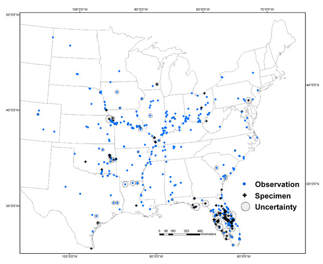
Because we include both observations and specimen data, the Carolina parakeet occurrence dataset presented here is the most comprehensive and rigorous datsetset on this species available. The dataset includes 861 sightings from 1564 to 1944. Each datapoint includes geographic coordinates, a measurement of uncertainty, detailed information about each sighting, and an assessment of the sighting's validity. Given that this species is so poorly understood, we make these data freely available to facilitate more research on this colorful and charismatic species.
Keywords
Carolina parakeet, Conuropsis carolinensis, distribution, extinction, Psittaciformes, North America
Introduction
The Carolina parakeet (Conuropsis carolinesis) was the only endemic North American parrot species north of the Rio Grande. The species likely went extinct in the first half of the 20th century (
It was only through Daniel McKinley's efforts were we able to compile this dataset. A vast majority of observations were detailed, with primary sources, in McKinley's numerous publications from 1959 to 1985 (e.g.
Adding to the lore surrounding Carolina parakeet observations, as late as the 1940s, ornithologist Oscar Bayard claimed that he knew of a remnant population of Carolina parakeets in rural Florida, but he refused to tell anyone where the birds were for fear that people would trap or kill the birds (
While data about Bayard's "lost population" has disappeared, some data may still be buried in obscure texts, waiting to be found. For instance, McKinley, who spent over 25 years writing about Carolina parakeets focusing primarily on the sightings recorded in each state, referenced two manuscripts in his writing that were never published, including a detailed account of sightings of Louisiana. We contacted his former university department to see if any of his writing or materials remained after his passing but his former collleagues could not find anything. We included as many observations as we could find from Louisiana, but it remains one of the most poorly represented states in our dataset. If other researchers find new citations or localities for the Carolina parakeet not found here, we encourage them to share them with us so we can update this dataset.
These data can be used in many avenues in research for this poorly understood species. In conjuction with modeling approaches, they may be able to help shed new light on the likely cause of the species' extinction, which remains a mystery. Accurate and precise georeferenced specimen data can be used in combination with genetic and stable isotope sampling, for example, to learn more about the relationship between the two subspecies and their dietary composition or foraging behaviour. Of the known extinct parrots, the Carolina parakeet had the largest range, by far (
Sampling methods
We collected and georeferenced locality data from Carolina parakeet specimens found in natural history collections around the world (n = 460) using online data repositories, and by contacting museums directly. We also compiled observations of Carolina parakeets from scientific literature, travel diaries, and other resources from 1564 to 1944 (n = 401). Specimens and observations were georeferenced using guidelines established by
Rather than using most existing coordinates associated with museum specimens found in online data repositories (e.g., VertNet), we re-estimated the geographical coordinates of almost every specimen based on collection locality names in order to ensure consistency throughout the dataset and remove the possibility of previous errors. Perhaps most importantly, re-estimating the coordinates allowed us to measure the geographic uncertainty for each sighting. However, we did not re-estimate coordinates and uncertainty for specimens that were already measured using the same guidelines we used, though these comprise a very small percentage of the dataset (n = 4). While more Carolina parakeet specimens exist in natural history museums and collections, many are either missing locality information or the locality information was not sufficient to georeference with confidence. Because the Carolina parakeet was unique among the North American avifauna, being the only parrot species (in addition to their bold yellow and red head, and raucous calls), we were confident that misidentification was unlikely in the published accounts of the observations.
In the dataset, we include reported sightings that experts consider dubious or questionable. We also include sightings of what are likely vagrant birds (from Colorado, Maryland, Michigan, New Jersey, New York, North Dakota, Pennsylvania, and South Dakota; see
Geographic coverage
The Carolina parakeet has two named subspecies differentiated by geographic range: C. c. carolinensis which occurred along coastal southeastern United States, and the more westerly C. c. ludovicianus (colloqiually known as the Louisiana parakeet), which had a range from central Texas to Nebraska, west to Ohio, and south to Louisiana, with little overlap with the eastern subspecies (
25.211111 and 47.99917 Latitude; -105.222778 and -74.20528 Longitude.
Taxonomic coverage
| Rank | Scientific Name | Common Name |
|---|---|---|
| kingdom | Animalia | |
| phylum | Chordata | |
| class | Aves | Birds |
| order | Psittaciformes | Parrots |
| family | Psittacidae | African & New World parrots |
| tribe | Arini | Macaws and parakeets |
| species | Conuropsis carolinensis | Carolina parakeet |
Temporal coverage
Some dates lack daily and/or monthly precision. Some sightings have no date data.
Usage rights
All data CC-Zero except when noted in the dataset.
Data resources
To facilitate broad use of these data, we formatted the dataset in accordance with Darwin Core standards (
| Column label | Column description |
|---|---|
| occurrenceID | An identifier for the Occurrence (as opposed to a particular digital record of the occurrence). In the absence of a persistent global unique identifier, construct one from a combination of identifiers in the record that will most closely make the occurrenceID globally unique. In this dataset, specimens use the ID number from its holding facilty; observations have their own unique observation ID. |
| eventDate | The date-time or interval during which an Event occurred. We present eventDate in ISO 8601 format. In some cases, day, month, or year data is missing. |
| year | The four-digit year in which the Event occurred, according to the Common Era Calendar. |
| locality | The specific description of the place. Less specific geographic information can be provided in other geographic terms (stateProvince, county). This term may contain information modified from the original to correct perceived errors or standardize the description. |
| stateProvince | The name of the next smaller administrative region than country (state, province, canton, department, region, etc.) in which the locality occurs. |
| county | The full, unabbreviated name of the next smaller administrative region than stateProvince (county) in which the locality occurs. |
| decimalLatitude | The geographic latitude (in decimal degrees, using the spatial reference system given in geodeticDatum) of the geographic center of a Location. Note the coordinates are very pricise, as they describe the very center of a polygon that encompasses all uncertainty associated with the locality (see coordinateUncertaintyInMeters). |
| decimalLongitude | The geographic longitude (in decimal degrees, using the spatial reference system given in geodeticDatum) of the geographic center of a Location. Note the coordinates are very pricise, as they describe the very center of a polygon that encompasses all uncertainty associated with the locality (see coordinateUncertaintyInMeters). |
| coordinateUncertaintyInMeters | The horizontal distance (in meters) from the given decimalLatitude and decimalLongitude describing the smallest circle containing the whole of the Location. |
| geodeticDatum | The ellipsoid, geodetic datum, or spatial reference system (SRS) upon which the geographic coordinates given in decimalLatitude and decimalLongitude as based. Data presented here in WGS84. |
| coordinatePrecision | A decimal representation of the precision of the coordinates given in the decimalLatitude and decimalLongitude. |
| georeferencedBy | A list (concatenated and separated) of names of people, groups, or organizations who determined the georeference (spatial representation) for the Location. In this case, K.R. Burgio, georeferenced all sightings but 4. |
| georeferencedDate | The date on which the Location was georeferenced in ISO 8601 format. |
| georeferenceSources | A list (concatenated and separated) of maps, gazetteers, or other resources used to georeference the Location, described specifically enough to allow anyone in the future to use the same resources. |
| georeferenceProtocol | A description or reference to the methods used to determine the spatial footprint, coordinates, and uncertainties. We used the GBIF best practices guidelines established by Chapman & Wieczorek (2006). |
| georeferenceRemarks | Notes or comments about the spatial description determination, explaining assumptions made in addition or opposition to the those formalized in the method referred to in georeferenceProtocol. |
| institutionCode | The name (or acronym) in use by the institution having custody of the object(s) or information referred to in the record. We include a list of abbreviation codes with the full name of the instutition in a separate .txt file with the dataset. |
| basisOfRecord | The specific nature of the data record. |
| recordedBy | A list (concatenated and separated) of names of people, groups, or organizations responsible for recording the original Occurrence. The primary collector or observer, especially one who applies a personal identifier (recordNumber), should be listed first. |
| associatedReferences | A list (concatenated and separated) of identifiers (publication, bibliographic reference, global unique identifier, URI) of literature associated with the Occurrence. |
| infraspecificEpithet | The name of the lowest or terminal infraspecific epithet. Here, we we relate subspecies identification as recorded on the specimen tag, if known. |
| eventRemarks | Comments or notes about the Event. |
| dynamicProperties | Assessment of quality of the sighting, based on expert opinion (see associated referenced for discussion of each sighting). The categories are: 1) "validity=Specimen" which indicates that a specimen exists, or did exist at one time. 2) "validity=Confirmed observation” which indicates that the observation is largely considered valid by either McKinley and/or Snyder. 3) “validity=Unconfirmed” is an observation that for one reason or another is considered controversial. 4) “vality=Likely invalid” is an observation or specimen that may be a result of fraud or mislabeling, pending independent verification. |
| collectionCode | The name, acronym, coden, or initialism identifying the collection or data set from which the record was derived. |
| catalogNumber | An identifier (preferably unique) for the record within the data set or collection. |
| license | A legal document giving official permission to do something with the resource. |
| rightsHolder | A person or organization owning or managing rights over the resource. |
| accessRights | Information about who can access the resource or an indication of its security status. Access Rights may include information regarding access or restrictions based on privacy, security, or other policies. |
| bibliographicCitation | A bibliographic reference for the resource as a statement indicating how this record should be cited (attributed) when used. Recommended practice is to include sufficient bibliographic detail to identify the resource as unambiguously as possible. |
| references | A related resource that is referenced, cited, or otherwise pointed to by the described resource. |
Acknowledgements
The authors would like to thank K. Block and G. Nuttall for help with data collection, M. MacFerrin for help with data formatting, the University of Connecticut Inter-Library Loan department for handling hundreds of interlibrary loan requests, and The Natural History Museum for funding. We'd also like to thank W.P. Corgan for making this all possible. Thanks to J. Wieczorek, R. Mounce, J. Stanton, and C. Hermes for their helpful feedback that greatly improved this manuscript. KRB was funded by NSF grant # DGE-0753455.
Author contributions
KRB designed data collection protocol & collected data. All authors verified data and wrote the manuscript.
References
- Lazarus ecology: Recovering the distribution and migratory patterns of the extinct Carolina parakeet.Ecology and Evolution7(14):5467‑5475. https://doi.org/10.1002/ece3.3135
- Spatial extinction date estimation: a novel method for reconstructing spatiotemporal patterns of extinction and identifying potential zones of rediscovery.bioRxivhttps://doi.org/10.1101/279679
- Guide to best practices for georeferencing.Global Biodiversity Information Facility,Copenhagen.
- Estimated dates of recent extinctions for North American and Hawaiian birds.Biological Conservation143(3):617‑624. https://doi.org/10.1016/j.biocon.2009.11.026
- Specimen-based modeling, stopping rules, and the extinction of the ivory-billed woodpecker.Conservation Biology26(1):47‑56. https://doi.org/10.1111/j.1523-1739.2011.01715.x
- The Writings of Thomas Jefferson.3.G.P. Putnam's Sons,New York.
- Phylogenetic relationships of the extinct Carolina Parakeet (Conuropsis carolinensis) inferred from DNA sequence data.The Auk129(2):197‑204. https://doi.org/10.1525/auk.2012.11259
- Original journals of the Lewis and Clark expedition, 1804-1806.Dodd, Mead & Company,New York.
- The Carolina Parakeet in the Upper Missouri and Mississippi River Valleys.The Auk82(2):215‑226. https://doi.org/10.2307/4082934
- The Carolina Parakeet in Florida.Florida Ornithological Society
- Ecological and socio-economic factors affecting extinction risk in parrots.Biodiversity and Conservation25(2):205‑223. https://doi.org/10.1007/s10531-015-1036-z
- The birds of North and Middle America.50.US Government Printing Office
- GEOLocate.3.22.Tulane University Museum of Natural History. URL: http://www.museum.tulane.edu/geolocate/
- The Carolina Parakeet: Glimpses of a vanished bird.Princeton University Press
- Carolina Parakeet (Conuropsis carolinensis).The Birds of North America Onlinehttps://doi.org/10.2173/bna.667
- Evaluation of the Nelson Carolina Parakeet Film.The Auk127(4):948‑951. https://doi.org/10.1525/auk.2010.10084
- Present-day risk assessment would have predicted the extinction of the passenger pigeon (Ectopistes migratorius).Biological Conservation180:11‑20. https://doi.org/10.1016/j.biocon.2014.09.023
- The interior Carolina paroquet as a Nebraska bird.Nebraska Bird Review2:55‑59.
- Darwin Core: An Evolving Community-Developed Biodiversity Data Standard.PLoS ONE7(1):e29715. https://doi.org/10.1371/journal.pone.0029715