|
Biodiversity Data Journal :
Data Paper (Biosciences)
|
|
Corresponding author: Hui Kim (huikim@mokpo.ac.kr)
Academic editor: Anatoliy Khapugin
Received: 25 Mar 2021 | Accepted: 05 May 2021 | Published: 10 Jun 2021
© 2021 Chin-Sung Chang, Shin Young Kwon, Hui Kim
This is an open access article distributed under the terms of the Creative Commons Attribution License (CC BY 4.0), which permits unrestricted use, distribution, and reproduction in any medium, provided the original author and source are credited.
Citation:
Chang C-S, Kwon SY, Kim H (2021) Historical collections of vascular plants in the Korean Peninsula by three major collectors in the early 20th century: U. J. Faurie, E. J. Taquet and E. H. Wilson. Biodiversity Data Journal 9: e66470. https://doi.org/10.3897/BDJ.9.e66470
|
|
Abstract
Background
The digitisation of historical collections aims to increase global access to scientific artifacts, especially those from currently inaccessible areas. Historical collections from North Korea deposited at foreign herbaria play a fundamental role in biodiversity transformation patterns. However, the biodiversity pattern distribution in this region remains poorly understood given the severe gaps in available geographic species distribution records. Access to a dominant proportion of primary biodiversity data remains difficult for the broader scientific and environmental community. The digitisation of foreign collectors’ botanical collections of around 60,000 specimens from the Korean Peninsula before World War II is ongoing. In this paper, we aim to fill this gap by developing the first comprehensive, open-access database of biodiversity records for the Korean Peninsula. This paper provides a quantitative and general description of the specimens that Urbain Jean Faurie, Emile Joseph Taquet and Ernest Henry Wilson have collected and are kept in several herbaria.
New information
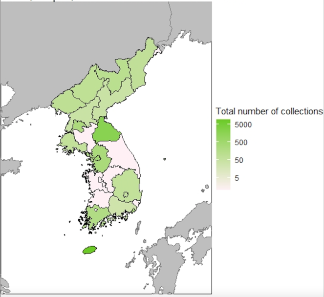
An open-access database of biodiversity records provides a simple guide to georeferencing historical collections. The first set describes E. H. Wilson’s collection of woody plants collected in the Korean Peninsula and preserved at the Harvard University Herbaria (A). This set includes 1,087 records collected from 1917 to 1918. The other collections contain specimens collected by E. J. Taquet (4,727 specimens from Quelpaert (Jeju), 1907–1914) and U. J. Faurie (3,659 specimens from North Korea and Quelpaert, 1901, 1906 and 1907). For each specimen, we recorded the species name, locality indication, collection date, collector, ecology and revision label. This set contains more than 9,400 specimens, with 22% of vascular plants from North Korea and 66% from Quelpaert (Jeju) Island. In these collections, we included some images that correspond to the specimens in this dataset.
Keywords
endonym, exonym, U.J. Faurie, georeferencing, herbarium collection, Korea, Quelpaert, E.J. Taquet, E.H. Wilson
Introduction
Institutions outside the Korean Peninsula hold much of the region’s historical biodiversity information. With nearly 100,000 specimens, including data on specimens stored at foreign herbaria, these institutions have a comprehensive chronological, historical, taxonomic and geographic coverage of Korean plants, including those from inaccessible areas such as North Korea. Despite the abundance of biodiversity information in these collections, there remains a pressing need to make such data accessible and sufficiently integrated to foster query-based enquiries and achieve regional conservation priorities. Creating this open-access database mobilises existing biodiversity information and knowledge within the Korean Peninsula. Through the advantages offered by a database, we could search through historical records of foreign herbaria, generate georeferenced specimen data and produce images of North and South Korean vascular plants. With these goals, the project addressed the imbalance in biodiversity information between South and North Korea and reduced the knowledge gap on the diversity and distribution of vascular plants in the Korean Peninsula.
Historical biodiversity data provide the context for past observations. Here, we present a vascular plant dataset of the Korean Peninsula covering the early 1900s. This dataset consists of three sets: (1) E. H. Wilson’s 1,087 specimens mainly from North Korea from 1917 and 1918; (2) E. J. Taquet’s 4,727 specimens from Quelpaert from 1907 to 1914; and (3) U. J. Faurie’s 3,659 specimens from North Korea and Quelpaert from 1901 to 1907.
These datasets were the first attempts at archive digitisation in both North and South Korea, covering an early period and incorporating data from different sources. The objective was to identify, describe, perform quality control and integrate historical data for the Korean Peninsula into standardised datasets and make them freely available and reliable for end users in terms of fitness for use (
Project description
Flora of the Korean Peninsula
Chin S. Chang and Hui Kim
This project includes specimens conserved in European, American and Japanese herbaria, which this paper identified via the following abbreviations proposed by Index Herbariorum (
This research was supported by a BIFA (the Biodiversity Information Fund for Asia) funded by the Ministry of the Environment (BIFA3_14), Government of Japan.
Sampling methods
Since 1945, the Korean Peninsula has been divided into what are now two countries: North Korea (Democratic People’s Republic of Korea) and South Korea (Republic of Korea). In terms of botanical importance, its notable islands include Jeju Island (Quelpaert) and Ulleung Island (Ulleungdo). Korea’s vascular flora includes 4,831 taxa (
E. H. Wilson collected 1,200 plant records representing 51 families that he identified with Alfred Rehder (
Both Faurie and Taquet did not number their collections chronologically, based on their collecting activities. They seem to have sorted the collections by genera and they assigned numbers to the taxonomic bundles of dried plants. Some of the collection data, such as locality, date or collection number, were missing. The first set of specimens is at E or P, except for some families. Duplicate specimens were widely distributed and could be found at BM, TI, KYO, A, LE and B. Faurie’s collection of several thousand herbarium specimens is deposited in Paris, with duplicates at the University of Kyoto, the British Museum, Kew and elsewhere (
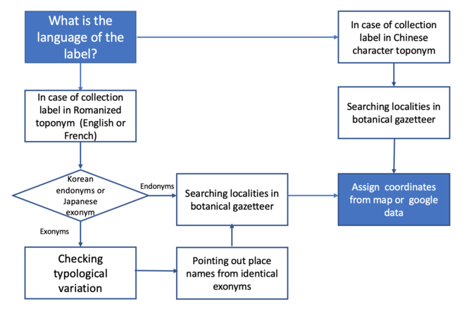
Georeferencing: A wide range of historically used toponyms in Korea have Chinese-character origins and can, therefore, be written the same way (
While most South Korean place names are derived from words in the Chinese character, Japanese botanists transliterated these place names into the Japanese pronunciation.
|
English names |
Japanese exonyms |
Endonyms |
Korean word |
|
Mountain Hwa |
Kazan |
Hwasan |
화산 |
|
Mountain Geumgang |
Konggo-san |
Geumgangsan |
금강산 |
|
Yeongheung |
Eiko |
Yeongheungeup |
영흥읍 |
|
Wonsan city |
Genzan |
Wonsansi |
원산시 |
|
Gwaneum peak |
Kannombo |
Gwameumbong |
관음봉 |
|
Pyohun temple |
Hyokunji |
Pyohunsa |
표훈사 |
After the identification of place names, the next step is providing a precise coordination to a biological collection. We always aimed for accurate georeferencing for location coordinates, but sometimes this was not possible because of insufficient information in the place names. Thus, in these situations, we used higher geographic area coordinates, such as counties or cities. To minimise errors, enhance data consistency and maintain integrity throughout the georeferencing process, we modified a procedure adopted by the Chinese type collection project (Fig.
Using the BRAHMS system, we set up a database of herbarium records. We compared the geographic queries with the label information for each specimen to resolve geographic information. We detected and corrected two types of errors: typographical errors and erroneously identified records. After updating the database with recent publications and cleaning the data, we obtained the clear collection data that corresponds to this dataset.
Finally, we generated the Darwin Core Archive to incorporate the metadata in this file and published the data on GBIF, using the Integrated Publishing Toolkit.
Geographic coverage
The Korean Peninsula is located in northeast Asia, between China and Japan. To the northwest, the Amnok River separates Korea from Liaoning Province in northern China and to the northeast, the Duman River separates Korea from Jirin Province in northern China and Far Eastern Russia. Excluding the islands, the Peninsula area covers about 220,847 km2. The eastern and northern parts of the Peninsula are characterised by the high mountains. The highest point of the Korean Peninsula is located at Mount Paektu (2,744 m a.s.l.;
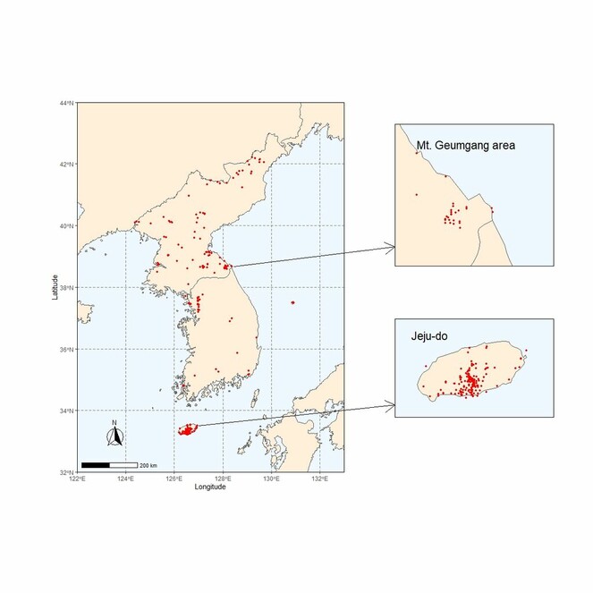
33°06'45.0"N and 43°00'42.3"N Latitude; 124°13'22.8"E and 131°52'22.5"E Longitude.
Taxonomic coverage
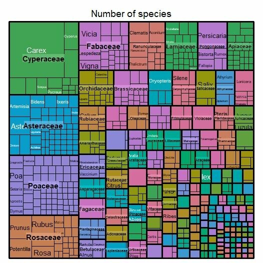
The majority of specimens belong to class Magnoliopsida (6,314 specimens) and Liliopsida (2,198), followed by Filicopsida (765), Lycopodiopsida (33), Equisetopsida (4), Coniferophyta (144) and Psilopsida (1). Our dataset represents 165 families (Fig.
| Rank | Scientific Name |
|---|---|
| phylum | Trachaeophyta |
Temporal coverage
1901 through 1919
Usage licence
Data resources
The total dataset contained about 13,981 herbarium specimens including duplicates deposited at several foreign herbaria and gathered by three collectors (U. J. Faurie, E. J. Taquet and E. H. Wilson) from the Korean Peninsula in the early 1900s (
This study presented the digitised data of all these vascular plant collections (1901–1918). The dataset was associated with image collections of plant specimens.
| Column label | Column description |
|---|---|
| type | The nature or genre of the resource. |
| institutionCode | The name (or acronym) in use by the institution having custody of the object(s) or information referred to in the record. |
| basisOfRecord | The specific nature of the data record. |
| occurrenceID | An identifier for the Occurrence (as opposed to a particular digital record of the occurrence). In the absence of a persistent global unique identifier, construct one from a combination of identifiers in the record that will most closely make the occurrenceID globally unique. |
| recordNumber | An identifier given to the Occurrence at the time it was recorded. Often serves as a link between field notes and an Occurrence record, such as a specimen collector's number. |
| recordedBy | A list (concatenated and separated) of names of people, groups or organisations responsible for recording the original Occurrence. The primary collector or observer, especially one who applies a personal identifier (recordNumber), should be listed first. |
| eventDate | The date-time or interval during which an Event occurred. For occurrences, this is the date-time when the event was recorded. Not suitable for a time in a geological context. |
| year | The four-digit year in which the Event occurred, according to the Common Era Calendar. |
| month | The integer month in which the Event occurred. |
| day | The integer day of the month on which the Event occurred. |
| country | The name of the country or major administrative unit in which the Location occurs. |
| countryCode | The standard code for the country in which the Location occurs. |
| stateProvince | The name of the next smaller administrative region than country (state, province, canton, department, region etc.) in which the Location occurs. |
| county | The full, unabbreviated name of the next smaller administrative region than stateProvince (county, shire, department etc.) in which the Location occurs. |
| locality | The specific description of the place. Less specific geographic information can be provided in other geographic terms (higherGeography, continent, country, stateProvince, county, municipality, waterBody, island, islandGroup). This term may contain information modified from the original to correct perceived errors or standardise the description. |
| decimalLatitude | The geographic latitude (in decimal degrees, using the spatial reference system given in geodeticDatum) of the geographic centre of a Location. Positive values are north of the Equator, negative values are south of it. Legal values lie between -90 and 90, inclusive. |
| decimalLongitude | The geographic longitude (in decimal degrees, using the spatial reference system given in geodeticDatum) of the geographic centre of a Location. Positive values are east of the Greenwich Meridian, negative values are west of it. Legal values lie between -180 and 180, inclusive. |
| geodeticDatum | The ellipsoid, geodetic datum or spatial reference system (SRS) upon which the geographic coordinates given in decimalLatitude and decimalLongitude are based. |
| coordinateUncertaintyInMetres | The horizontal distance (in metres) from the given decimalLatitude and decimalLongitude describing the smallest circle containing the whole of the Location. Leave the value empty if the uncertainty is unknown, cannot be estimated or is not applicable (because there are no coordinates). Zero is not a valid value for this term. |
| georeferencedBy | A list (concatenated and separated) of names of people, groups or organisations who determined the georeference (spatial representation) for the Location. |
| identifiedBy | A list (concatenated and separated) of names of people, groups or organisations who assigned the Taxon to the subject. |
| typeStatus | A nomenclatural type (type status, typified scientific name, publication) applied to the subject. |
| scientificName | The full scientific name, with authorship and date information, if known. When forming part of an Identification, this should be the name in lowest level taxonomic rank that can be determined. This term should not contain identification qualifications, which should instead be supplied in the IdentificationQualifier term. |
| kingdom | The full scientific name of the kingdom in which the taxon is classified. |
| phylum | The full scientific name of the phylum or division in which the taxon is classified. |
| class | The full scientific name of the class in which the taxon is classified. |
| order | The full scientific name of the order in which the taxon is classified. |
| family | The full scientific name of the family in which the taxon is classified. |
| genus | The full scientific name of the genus in which the taxon is classified. |
| specificEpithet | The name of the first or species epithet of the scientificName. |
| infraspecificEpithet | The name of the lowest or terminal infraspecific epithet of the scientificName, excluding any rank designation. |
| taxonRank | The taxonomic rank of the most specific name in the scientificName. |
| scientificNameAuthorship | The authorship information for the scientificName formatted according to the conventions of the applicable nomenclaturalCode. |
| vernacularName | A common or vernacular name. |
| nomenclaturalCode | The nomenclatural code (or codes in the case of an ambiregnal name) under which the scientificName is constructed. |
| taxonomicStatus | The status of the use of the scientificName as a label for a taxon. Requires taxonomic opinion to define the scope of a taxon. Rules of priority then are used to define the taxonomic status of the nomenclature contained in that scope, combined with the experts opinion. It must be linked to a specific taxonomic reference that defines the concept. |
| acceptedNameUsage | The full name, with authorship and date information, if known, of the current botanical taxon. |
Additional information
Biographical notes
The French missionary and botanist Fr. Urbain Jean Faurie (1847–1915) and Emile Joseph Taquet (1873–1952) greatly contributed to the understanding of the vascular flora on the Korean Peninsula and Quelpaert Island in the early 1900s. Taquet was born in Hecq, Quesnoy in France and was ordained when he was 24. As a local catholic priest and a field collaborator with Faurie, he made extensive collections of vascular plants on Island of Quelpaert from 1907 to 1915. Taquet stopped collecting plants when missionary Faurie died in Taiwan in 1915. In 1952, Taquet passed away at St Justin Catholic Seminary in Daegu, Korea. The major portions of their collected specimens are housed at E, P, TI and KYO. After the distribution to European and Japanese herbaria, many botanists have studied Faurie’s and Taquet’s collections: E. Hackel, A. E. Finet, P. C. Tsoong, H. Wolff, G. Koidzumi (
References
- The great plant collectors ‘Chinese’ Wilson : A life of Ernest H. Wilson, 1876-1930.The Royal Botanic Gardens, Kew and Edinburgh,London.
- The vascular plants collection (P) at the Herbarium of the Muséum National d'Histoire Naturelle (MNHN - Paris).69.192.MNHN - Museum national d'Histoire naturelle. Release date:2020-12-20. URL: https://doi.org/10.15468/nc6rxy
- Reexamination on foreign collectors' sites and exploration routes in Korea - with respect to U. Faurie.Korean Journal of Plant Taxonomy34(2):87‑96. [InKorean]. https://doi.org/10.11110/kjpt.2004.34.2.087
- Provisional checklist of vascular plants for the Korea Peninsula Flora (KPF).Design Post,Paju.
- Botanical gazetteer for Korean Peninsula Flora (KPF).Design Post,Paju.
- The Red List of vascular plants in Korea updated 2018.Korea National Arboretum of Korea Forest Service and Korean Plant Specialist group,Pocheon.
- Flora of the Korean Peninsula. Version 1.18. Occurrence dataset.TB Lee Herbarium via GBIF.org. URL: https://doi.org/10.15468/fyxnsd
- Principles of data quality.GBIF
- The use of Hanja (Chinese characters) in Korean toponyms: Practices and issues.Onoma51:13‑24. https://doi.org/10.34158/onoma.51/2016/2
- Filices coreanae novae.Feddes Repertorium5:284‑285. https://doi.org/10.1002/fedr.19080051516
- A considerable review on type specimens of Korean vascular plants in the Herbarium of the Komarov Botanical Institute (LE) Addition.Journal of Species Research7(1):73‑79. https://doi.org/10.12651/JSR.2018.7.1.073
- Père Urbain Faurie.The Botanical Magazine, Tokyo30(356):267‑273. https://doi.org/10.15281/jplantres1887.30.267
- Abbé Urbain Faurie and an itinerary calendar of his plant hunting.Acta Phytotaxonomica et Geobotanica43(1):59‑74. [InJapanese]. https://doi.org/10.18942/bunruichiri.KJ00001078965
- E. H. Wilson’s expedition to Korea from 1917 to 1919: Resolving place names of his collections.Journal of Japanese Botany85(2):99‑117.
- Literature on Urbain Faurie.Acta Phytotaxonomica et Geobotanica30(1-3):93‑98. [InJapanese]. https://doi.org/10.18942/bunruichiri.KJ00001078315
- A historical sketch of herbal and botanical investigations on the flora of Nippon.Acta Phytotaxonomica et Geobotanica5(1):1‑26. [InJapanes]. https://doi.org/10.18942/bunruichiri.KJ00002992862
- A brief history of the laboratory of systematic botany (Prof. G. Koidzumi), the botanical Institute of, Faculty of Science, Kyoto Imperial University.Acta Phytotaxonomica et Geobotanica13:309‑313. [InJapanese]. https://doi.org/10.18942/bunruichiri.KJ00002992581
- Decades plantarum novarum I.Repertorium Specierum Novarum Regni Vegetabilis4:225‑334. https://doi.org/10.1002/fedr.19070041502
- Carices novae coreanae.Repertorium Specierum Novarum Regni Vegetabilis5:239‑241. https://doi.org/10.1002/fedr.19080051505
- Decades plantarum novarum IV/V.Repertorium Specierum Novarum Regni Vegetabilis5:8‑12. https://doi.org/10.1002/fedr.19080050105
- Decades plantarum novarum VII.Repertorium Specierum Novarum Regni Vegetabilis5:194‑195. https://doi.org/10.1002/fedr.19080051304
- Decades plantarum novarum VIII-X.Repertorium Specierum Novarum Regni Vegetabilis5:279‑284. https://doi.org/10.1002/fedr.19080051515
- Decades plantarum novarum XX, XXI.Repertorium Specierum Novarum Regni Vegetabilis7:197‑200. https://doi.org/10.1002/fedr.19090071304
- Decades plantarum novarum XXXIII.Repertorium Specierum Novarum Regni Vegetabilis8:258‑259. https://doi.org/10.1002/fedr.19100081702
- Decades plantarum novarum XXXIV-XXXVII.Repertorium Specierum Novarum Regni Vegetabilis8:280‑286. https://doi.org/10.1002/fedr.19100081708
- Decades plantarum novarum XXXIX.Repertorium Specierum Novarum Regni Vegetabilis8:401‑402. https://doi.org/10.1002/fedr.19100082601
- Georeferencing the Natural History Museum's Chinese type collection: of plateaus, pagodas and plants.Biodiversity Data Journal8:e50503. https://doi.org/10.3897/bdj.8.e50503
- Flora Koreana I.The Journal of the College of Science, Imperial University of Tokyo, Japan26:1‑304.
- Flora Koreana II.The Journal of the College of Science, Imperial University of Tokyo, Japan31:1‑573.
- Royal Botanic Gardens, Kew - Herbarium Specimens. Occurrence dataset. Release date:2020-12-29. URL: https://doi.org/10.15468/ly60bx
- Standardisation of place names in countries influenced by the Chinese writing system.Semestrale di Studi e Ricerche di Geografia2:115‑121. https://doi.org/10.13133/1125-5218.15163
- treemap: Treemap Visualization. R package.2.4-2. Release date:2020-12-29. URL: https://CRAN.R-project.org/package=treemap
- Index Herbariorum: A global directory of public herbaria and associated staff.New York Botanical Garden’s Virtual Herbarium. Release date:2020-12-29. URL: http://sweetgum.nybg.org/ih