|
Biodiversity Data Journal :
Data Paper (Biosciences)
|
|
Corresponding author: Varos G Petrosyan (vgpetrosyan@gmail.com)
Academic editor: Alexander Balakirev
Received: 26 May 2021 | Accepted: 17 Jun 2021 | Published: 22 Jun 2021
This is an open access article distributed under the terms of the CC0 Public Domain Dedication.
Citation:
Khlyap LA, Dinets V, Warshavsky AA, Osipov FA, Dergunova NN, Petrosyan VG (2021) Aggregated occurrence records of the invasive alien striped field mouse (Apodemus agrarius Pall.) in the former USSR. Biodiversity Data Journal 9: e69159. https://doi.org/10.3897/BDJ.9.e69159
|
|
Abstract
Background
Open access to occurrence records of the most dangerous invasive species in a standardised format have important potential applications for ecological research and management, including the assessment of invasion risks, formulation of preventative and management plans in the context of global climate and land use changes in the short and long perspective. The striped field mouse (Apodemus agrarius Pallas, 1771) is a common species in the temperate latitudes of the Palaearctic. Due to land use and global climate changes, several waves of expansion of the range of this species have been observed or inferred. By intrusion into new regions, the striped field mouse has become an alien species there. Apodemus agrarius causes significant harm to agriculture and is one of the most important pests of grain crops. In tree nurseries, A. agrarius destroys seeds of valuable tree species and gnaws at the bark of saplings of broadleaf species and berry bushes. It is one of the most epidemiologically important rodents, involved in the circulation of the causative agents of haemorrhagic fever with renal syndrome (HFRS) and many other zoonotic infections. The foregoing allows us to classify the striped field mouse as a dangerous invasive alien species in the expanding part of the range. A lot of data accumulated for this species are of interest from both ecological and applied points of view. The accumulation and aggregation of data on the occurrence records of A. agrarius is relevant for the study of ecology, biogeography and construction of the spatial distribution and ecological niche models in the context of global climate change. We have created a dataset of 1603 occurrence records of this species, collected from 1936 to December 2020 by various zoologists, previously published or original. These records relate to a significant part of the striped field mouse’s range in Russia (1264 records) and neighbouring countries (339 records). The dataset shows the position of the northern and central parts of A. agrarius range, the disjunction of the range in Transbaikalia and isolated populations in the north of the range. The data were obtained in different formats from literature, indicating different degrees of accuracy of geographic coordinates and with several variations of the species' name. In the process of aggregating and fixing errors, we created a set of georeferenced occurrence records, adopted a controlled vocabulary, removed duplicates and standardised the format of records using unified data structure. We examined the dataset for inconsistencies with the taxonomic position of A. agrarius and removed the incorrect records. This paper presents the resulting dataset of A. agrarius occurrence records in the territory of Russia and neighbouring countries in a standardised format.
New information
This is a validated and comprehensive dataset of occurrence records of A. agrarius, including both our own observations and records from literature. This dataset is available for extension by other researchers using a standard format in accordance with Darwin Core standards. In different countries, there are a lot of occurrence records for the striped field mouse, but the overwhelming part of them is presented in separate literary sources, stored in the form of maps and in zoological collections. Prior to this project, such information was not available to a wide range of researchers and did not allow the use of these spatial data for further processing by modern methods of analysis, based on geographic information systems (GIS technologies). The created dataset combines species occurrence records of many Soviet zoologists who studied the distribution of the striped field mouse over a significant part of its recent range, in Russia and neighbouring countries (within the former USSR). The final set of records was created by combining the species occurrence records using a uniform data structure, checking geographic coordinates and removing duplicate and erroneous records. The dataset expands the available information on the spatial and temporal distribution of the dangerous invasive species in Russia and neighbouring countries of the former USSR (Estonia, Latvia, Lithuania, Belarus, Ukraine, Moldova, Georgia, Azerbaijan, Kazakhstan and Kyrgyzstan).
Keywords
invasive species, distribution, occurrence records, agrophil, hemisinanthrope, zoonotic diseases
Introduction
Apodemus agrarius (Pallas, 1771) is the single representative of the subgenus Apodemus in the fauna of Russia (
Native range
Limits of the native range are not clear. It consists of two isolated parts: western (in Europe, Siberia and Kazakhstan) and eastern (in Russian Far East, China and Korea). Molecular genetic studies have shown that the eastern part of the range is considered to be more ancient (
Recent distribution
The isolation of two large parts of the range is still recent. Up to the mid-20th century, the western part extended from Central Europe to the upper Angara River (
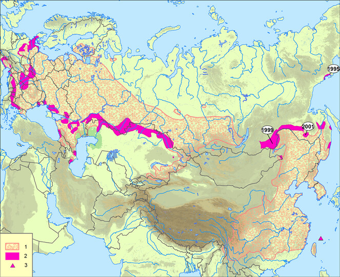
Dynamics of range of Apodemus agrarius (
The eastern part of range previously extended from the Amur Region and southern Ussuriland, through Korea and much of eastern and southern China, reaching northern Myanmar (
Pathways and vectors of invasions
The striped field mouse is an ancient agrophilic invader. With the beginning of human cultivation of land, mice began to populate cereal crops and associated weeds, where the number of mice became higher than in natural habitats (
In the second half of the 20th century, range expansion was noted in Germany, Italy, Austria, Czech Republic, Slovakia, Hungary, Slovenia, Ukraine (
Invasion of the striped field mouse into new regions of eastern Russia was noted in Amur Region in the second half of the 20th century (
Habitat
In undisturbed habitats, the striped field mouse usually inhabits floodplains with grassy vegetation and sparse forest, moist ravines and gullies, banks of water bodies covered with bushes, reeds, cattail and sedge (
Impact on other species, ecosystems and humans
The striped field mouse is one of the most important pests of crops and causes significant damage to agriculture, especially during peak years. In forest nurseries, it destroys the seeds of valuable tree species and nibbles the bark of saplings of broadleaf species and berry bushes. It pollutes and destroys agricultural produce in warehouses (
The primary data on occurrence of A. agrarius are important for ecological research and management, including the assessment of invasion risks, formulation of preventative and management plans in the context of global climate change and land use. These data are also important for the prediction of potential habitats of the species using modern methods of modleling ecological niches. Refined, validated and reformatted spatio-temporal distribution data can help prevent further spread of this invasive species.
Our goal was to combine the accumulated knowledge and expertise of historical data to create a validated, publicly available dataset in a modern format on occurrence records in Russia and neighbouring countries. To achieve this goal, the following tasks were undertaken: 1) To preserve and ensure the availability of the results of the fieldwork of many Soviet zoologists who have studied the distribution of striped field mouse in Russia and other countries of the former USSR; 2) To map the distribution records of the striped field mouse over a significant part of its range; 3) To provide data on the expansion of the species’ range in Russia and neighbouring countries for the second half of the 20th century and the beginning of the 21st century and 4) To create a valid dataset for modelling the ecological niche of the species and its dynamics for the entire range or its large parts.
General description
The striped field mouse is included in the TOP-100 list of the most dangerous invasive species in Russia (
Project description
Aggregated occurrence records of the invasive alien striped field mouse (Apodemus agrarius Pall.) in Russia and neighbouring countries.
The study area covers most of the distribution range of the striped field mouse (A. agrarius). In Russia, the westernmost records lie in Kaliningrad Region, the northernmost in Arkhangelsk Region, the easternmost in Magadan Region and the southernmost in Dagestan Republic. The study area also includes the territories of neighbouring countries: Estonia, Latvia, Lithuania, Belarus, Ukraine, Moldova, Georgia, Azerbaijan, Kazakhstan and Kyrgyzstan. The dataset includes occurrence records on the northern and north-eastern limits of the species range, the southern limit of distribution in the Caucasus and characterises the central part of the species range. These records also show a disjunction between the western and eastern parts of the range, which lies between Lake Baikal and the Upper Amur Basin.
Sampling methods
Striped field mouse occurrence records were collected from various sources: field data gathered by Soviet zoologists over 40 years, including ~ 20,000 capture records; collections in zoological museums (the Zoological Museum of Moscow State University, the Museum of the Zoological Institute of the Russian Academy of Sciences in St. Petersburg and the Siberian Zoological Museum in Novosibirsk); records obtained by Epidemiology Control Stations of Russia; literature data (
A significant part of the occurrence records (1453) was obtained from the map "Distribution of striped field mouse in the USSR", published by Karaseva et al. (
Occurrence records sources of striped field mouse. The total number of occurrences (1603) obtained from each source are listed as of December 2020.
|
Source |
Number of records |
|
|
61 |
|
|
1453 |
|
|
52 |
|
|
1 |
|
|
5 |
|
|
1 |
|
|
13 |
|
|
1 |
|
|
2 |
|
|
4 |
|
Original records (2017-2020) |
10 |
Literature data covering the time interval 1936-2020 (Table
We used the data presented in Tikhonova et al. (
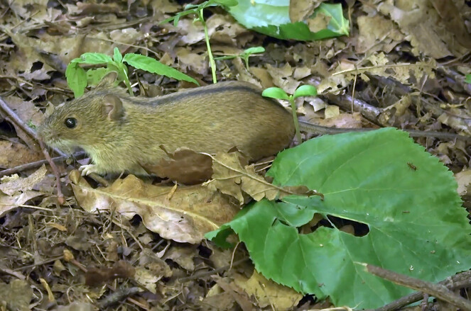
When analysing and checking specimens, only those for which the location could be determined were included in the dataset. A significant part of the records were taken from publications authored or verified by leading Russian zoologists (VN Bolshakov, LV Frisman, EV Karaseva, IV Kartavtseva, VV Kucheruk, IL Kulik, NA Nikitina, NM Okulova, MV Pavlenko, AK Tembotov and GN Tikhonova) to ensure correct identification of the specimens. The striped field mouse is easy to distinguish from other rodents of the Palearctic fauna by its colour pattern and morphology. It is a black dorsal stripe, clearly visible against the greyish-ochre colour of the back fur (Fig.
baseOfRecord: Data records with an unknown baseOfRecord were removed from our dataset to ensure that all accepted records were based on observation data.
ScientificName: The striped field mouse was originally described by Pallas (1771) as Mus agrarius Pallas, 1771 and there are occurrence records in literature by different names due to the existence of synonyms and invalid subspecific designations. Wilson and Reeder (
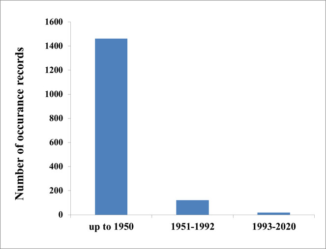
eventDate: Our dataset concerns an invasive species and it was important to reflect the timing of invasions. According to the Darwin Core specification, the column indicates the time interval during which the event — the appearance of the striped field mouse — took place. Analysis of literature only made it possible to divide that information on the first records into three time intervals (cases). The first case corresponds to the interval 1936/1992, which means that the species was first recorded between 1936 and 1992 and remains present now (there is no data on extinction). The second case corresponds to the interval 1951/1992, which means that the species appeared between 1951 and 1992. For the third case, the specific year after 1992 is used. The separation of the date records into time intervals is important for characterizing the regions of invasion of the striped field mouse.
Data within columns were edited using controlled vocabulary and Darwin Core standards. Primary data were retained when controlled vocabulary could not be utilised. Spelling or transcription errors were noted and changed to reflect the correct spelling of the species. We removed duplicate records from multiple sources by removing occurrences with identical eventDates. Corrected data were formatted according to Darwin Core standards (
Geographic coverage
The geographic range of the dataset covers the territory of Russia and neighbouring countries within the borders of the former USSR (Estonia, Latvia, Lithuania, Belarus, Ukraine, Moldova, Georgia, Azerbaijan, Kazakhstan and Kyrgyzstan) (Fig.
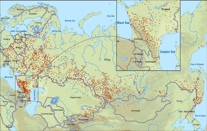
A significant part of the occurrence records 78.9% (1264) are located in Russia, in the Baltic countries bordering on Russia: Estonia, Latvia, Lithuania 1.5% (24) records are registered, in the eastern European countries of former USSR - Belarus, Ukraine and Moldova, there are 10% (161) records, in the south-western part of the range on the territory of Georgia and Azerbaijan 1.2% (20) records are registered, in the territory of Asian countries - Kazakhstan and Kyrgyzstan, there are a relatively large number of records 8.3% (134) (Table
The number of Apodemus agrarius occurrence records across the study area as of December 2020.
|
Country |
Nuber of provinces /regions |
Number of records |
|
Estonia |
1 |
1 |
|
Latvia |
7 |
14 |
|
Lithuania |
9 |
9 |
|
Belarus |
6 |
36 |
|
Ukraine |
24 |
116 |
|
Moldova |
9 |
9 |
|
Georgia |
6 |
11 |
|
Azerbaijan |
7 |
9 |
|
Kazakhstan |
10 |
129 |
|
Kyrgyzstan |
2 |
5 |
|
Russia |
72 |
1264 |
39.1271 and 64.8069 Latitude; 21.2661 and 150.9325 Longitude.
Taxonomic coverage
This dataset is devoted to one species of Rodentia in the family Muridae (Apodemus agrarius).
Temporal coverage
Usage licence
IP rights notes:
See individual records for usage rights.
Data resources
Data are formatted according to Darwin Core standards (http://rs.tdwg.org/dwc/terms) and the column labels and column descriptions are based on this standard.
| Column label | Column description |
|---|---|
| id | The name or acronym in use by the institution having custody of the object(s) or information referred to in the record. |
| bibliographicCitation | A bibliographic reference for the resource as a statement indicating how this record should be cited (attributed) when used. Any data records that were edited cite this data paper in this column. |
| basisOfRecord | The specific nature of the data record. We used a Darwin Core controlled vocabulary for our basisOfRecord that included "HumanObservation". |
| occurrenceID | In this dataset, occurrence records use the ID number from its holding facility when applicable. Occurrence records that did not have a unique ID were given their own unique observation ID. |
| occurrenceRemarks | Comments or notes about the occurrence. |
| eventDate | The date-time or interval during which an Event occurred. For occurrences, this is the data-time when the event was recorded. |
| habitat | A category or description of the habitat in which the Event occurred. |
| fieldNumber | An identifier given to the event in the field. Often serves as a link between field notes and the Event. |
| eventRemarks | Comments or notes about the Event. |
| countryCode | The standard code for the country in which the Location occurs. |
| stateProvince | The name of the next smaller administrative region than country (state, province, canton, department, region etc.) in which the Location occurs. |
| county | The full, unabbreviated name of the next smaller administrative region than stateProvince (county, shire, department etc.) in which the Location occurs. |
| locality | The specific description of the place. Less specific geographic information can be provided in other geographic terms (higherGeography, continent, country, stateProvince, county, municipality, waterBody, island, islandGroup). This term may contain information modified from the original to correct perceived errors or to standardise the description. |
| verbatimLocality | The original textual description of the place. |
| decimalLatitude | The latitude of the location from which the catalogued item was collected, expressed in decimal degrees. |
| decimalLongitude | The longitude of the location from which the catalogued item was collected, expressed in decimal degrees. |
| geodeticDatum | The ellipsoid, geodetic datum or spatial reference system (SRS) upon which the geographic coordinates given in decimalLatitude and decimalLongitude are based. Recommended best practice is use of the EPSG code as a controlled vocabulary to provide an SRS, if unknown. Otherwise, use of a controlled vocabulary for the name or code of the geodetic datum, if unknown. |
| coordinateUncertaintyInMetres | The horizontal distance (in metres) from the given decimalLatitude and decimalLongitude describing the smallest circle containing the whole of the Location. Leave the value empty if the uncertainty is unknown, cannot be estimated or is not applicable (because there are no coordinates). Zero is not a valid value for this term. |
| georeferenceSources | A list (concatenated and separated) of maps, gazetteers or other resources used to georeference the Location, described specifically enough to allow anyone in the future to use the same resources. |
| scientificName | The full scientific name. |
| kingdom | The full scientific name of the kingdom in which the taxon is classified. |
| taxonRank | The taxonomic rank of the most specific name in the scientificName. |
Acknowledgements
We are thankful to many people for their efforts in collecting, aggregating and publishing data. Our thanks extend to B.I. Sheftel, who provided valuable advice to exclude questionable occurrence records. We are especially grateful for the time and effort of Nina Filippova for publication of the dataset using the GBIF Integrated Publishing Toolkit. The study was supported by the Russian Science Foundation, Project № 21-14-00123. The authors are also grateful to ESRI (USA) for providing a free-of charge licensed version of ArcGIS Desktop Pro 10.4.1 (ESRI Sales Order number 3128913; ESRI Delivery number 81833751, User customer number 535452).
Author contributions
LAK collected and systematised occurrence records, made the literature review and wrote the text; VD wrote, translated and revised the text; AAW prepared the maps; FAO validated the occurrence records and revised the text; NND revised the text; VGP validated the occurrence records, made the literature review and wrote the text.
References
- Behavioral peculiarities of the striped field mouse (Apodemus agrarius) from two urban populations.Zoologicheskii Zhurnal87(2):231‑238. [InRussian].
- Synurbization processes in a population of Apodemus agrarius.Acta Theriologica23:341‑358. https://doi.org/10.4098/AT.arch.78-24
- Current distribution of the striped field mouse (Apodemus agrarius Pallas, 1771) in Eastern Transbaikalia: New findings in the disjunction area.Russian Journal of Biological Invasions6(1):1‑5. https://doi.org/10.1134/s2075111715010026
- Population ecology of small mammals in the floodplain forests of the Sakmara River (Orenburg Region).Bulletin of the Orenburg State University,Orenburg,104-107pp. [InRussian].
- The most dangerous invasive species of Russia (TOP-100).KMK Scientific Press,Moscow,688pp. [InRussian].
- Unwanted introduction of a striped field mouse into the Magadan Region.Kolymskiye Vesti14:19‑20. [InRussian].
- Guide book of the mammals in Mongolia.Pubhshing House of the Mongolian Academy of Science,Ulaanbaatar,390pp.
- Flora and fauna of the middle taiga of the Arkhangelsk Region (between the Ustya and Kokshenga Rivers).Faculty of Geography, Moscow State University,Moscow,70pp. [InRussian].
- Leptospira genomospecies and sequence type prevalence in small mammal populations in Germany.Vector-Borne and Zoonotic Diseases18(4):188‑199. https://doi.org/10.1089/vbz.2017.2140
- Spotted fever rickettsiae in wild-living rodents from south-western Poland.Parasites & Vectors10(1). https://doi.org/10.1186/s13071-017-2356-5
- GBIF occurrence download.The Global Biodiversity Information Facilityhttps://doi.org/10.15468/dl.xz0fd8
- Apodemus agrarius. In:The Atlas of European Mammals.Academic Press,London, UK,560pp.
- Mammals of fauna of USSR.Izdatel'stvo USSR AS,Moscow-Leningrad,638pp. [InRussian].
- Features of the population biology of some alien mammalian species in the southern taiga zone of the European part of Russia.Bulletin of the Pskov State University. Series "Natural, physical and mathematical sciences”2:16‑29. [InRussian].
- Apodemus agrarius (Pallas, 1771). In:The Wild Mammals of Japan.2nd.Shoukadoh,Tokyo,172pp.
- Apodemus agrarius.IUCN Red List of Threatened Specieshttps://doi.org/10.2305/iucn.uk.2016-3.rlts.t1888a22422191.en
- Winter observations of the circulation of Pomona leptospira among striped field mice of North Ossetia.Microbiology, Epidemiology & Immunobiology42(7):89‑93. [InRussian].
- Apodemus agrarius Pallas, 1771 - striped field mouse. In:Medical Theriology.Nauka,Moscow,194-203pp. [InRussian].
- The distribution of the striped field mouse (Apodemus agrarius) in the USSR and peculiarities of its ecology in different parts of its range.Zoologicheskii Zhurnal71(6):106‑115. [InRussian].
- Population structure of the range of the facultative synanthropus - striped field mouse in the USSR.In:Synanthropy of rodents and limitation of their numbers.Nauka,Moscow,280-300pp. [InRussian].
- Mammals of Moscow in the past and present.Nauka,Moscow,244pp. [InRussian].
- Features of the distribution and lifestyle of the striped field mouse (Apodemus agrarinus Pall.) in undeveloped areas of Moscow.Bulletin of Moscow Society of Naturalists. Biological Series, Moscow University Press104(5):73‑80. [InRussian].
- Apodemus agrarius Pallas - striped field mouse. In:Agro-ecological Atlas of Russia and Adjacent Countries: Economically Important Plants, Their Pests, Diseases and Weeds. [InRussian]. URL: http://www.agroatlas.ru/ru/content/pests/Apodemus_agrarius/
- New data on the boundaries of distribution of small mammals in the Russian Far East.In:Theriofauna of Russia and adjacent territories. International Meeting (IX Congress of the Theriological Society at the Russian Academy of Sciences).KMK Scientific Press,Moscow,202pp. [InRussian].
- The taxonomy and distribution of Apodemus agrarius (Pallas, 1771) (Mammalia: Rodentia) in the European part of Turkey.Turkish Journal of Zoology27:141‑146.
- Mice of the genus Apodemus of the Central Ciscaucasia. Dissertation for the degree of candidate of biological sciences.Stavropol State University,Stavropol,272pp. [InRussian].
- Striped field mouse (Apodemus agrarius Pall.) occurrences in Russia and adjacent countries according to published data. https://doi.org/10.15468/fv3hn3. Accessed on: 2021-6-04.
- Proceedings of IV Congress of the USSR Theriological Society,1.366-367pp. [InRussian].
- Synanthropic and agrophilic rodents as invasive alien mammals.Russian Journal of Biological Invasions1(4):301‑312. https://doi.org/10.1134/s2075111710040089
- Complex evolution and epidemiology of Dobrava-Belgrade hantavirus: definition of genotypes and their characteristics.Archives of Virology158(3):521‑529. https://doi.org/10.1007/s00705-012-1514-5
- Genetic diversity of Bartonella genotypes found in the striped field mouse (Apodemus agrarius) in Central Europe.Parasitology143(11):1437‑1442. https://doi.org/10.1017/s0031182016000962
- Reasons determining the species composition and abundance of rodents in hay, straw or grain stacks in the south of the Moscow Region.Zoologicheskii Zhurnal32(3):495‑505. [InRussian].
- Rodents — inhabitants of buildings of man and settlements in various regions of the USSR. In:General and Regional Theriogeography.Nauka,Moscow,165-237pp. [InRussian].
- Rodents of hay ricks and straw stacks.Questions of regional, general and experimental parasitology and medical zoology7:284‑317. [InRussian].
- Ecological structure of the striped field mouse population. In:Fauna and Ecology of Rodents.10.Moscow State University Press,Moscow,187-198pp. [InRussian].
- Phylogeography of the striped field mouse, Apodemus agrarius (Rodentia: Muridae), throughout its distribution range in the Palaearctic Region.Mammalian Biology100(1):19‑31. https://doi.org/10.1007/s42991-019-00001-0
- Hantaviruses and Hantavirus Infections (to the 70th Anniversary of HFRS Reaserch in the Russian Far East).Primpoligrafkombinat,Vladivostok,20-42pp.
- The Atlas of European Mammals.Poyser,London,484pp.
- On population adaptations of synurbized rodent species in the urban environment. In:Actual Problems of Biology.Barnaul State University Press,Barnaul,124-127pp. [InRussian].
- Formation of rodent communities in arable lands of Northen Eurasia.Russian Journal of Ecology32(5):326‑333. https://doi.org/10.1023/A:1011922226754
- Features of the territory using by striped field mice (Apodemus agrarius Pall.).Zoologicheskii Zhurnal37(9):1387‑1408. [InRussian].
- The mobility of striped field mice in connection with their importance in feeding ticks in the foothills of Altai.Medical Parazitology and Parasitic Diseases29(1):31‑39. [InRussian].
- Mammals of mountain areas. Proceeding of the International Conference.KMK Scientific Press,Moscow,122 – 130pp. [InRussian].
- On the ecology of the striped field mouse (Apodemus agrarius Pall.) in the forest-steppe. Chernozemye, I.Povolzhskiy Journal of Ecology2(2):174‑184. [InRussian].
- On the ecology of the striped field mouse (Apodemus agrarius Pall.) in the forest-steppe. Chernozemye, II. Biotopes and food.Povolzhskiy Journal of Ecology3:370‑378. [InRussian].
- On the ecology of the striped field mouse (Apodemus agrarius Pall.) in the forest-steppe Chernozemye. III. Composition and reproduction.Povolzhskiy Journal of Ecology3:268‑277. [InRussian].
- Changes in the distribution of mesophilic mammals in the steppes of the Volga-Ural interfluve in connection with climate humidification and anthropogenic transformation of landscapes.Arid Ecosystems12(30-31):32‑42.
- Environmental cooperation of the Chita Region (Russian Federation) and the Inner Mongolia autonomous region (PRC) in transboundary ecological regions.Proceeding of the International Conference,Transbaikal Humanities Pedagogical University.Chita,260-265pp. [InRussian].
- Oder Rodentia. In:The Mammals of Russia: A Taxonomic and Geographic Reference.KMK Scientific Press,Moscow,142-312pp.
- Genetic features and the putative sources of formation of isolated populations of the striped field mouse Apodemus agrarius Pallas, 1771 in Magadan Region.Russian Journal of Biological Invasions8(1):87‑100. https://doi.org/10.1134/s2075111717010106
- To biology and ecology of Apodemus agrarius mantschuricus Thom, and dynamics of its reproduction.Bulletin of the Far Eastern Branch of the Soviet Academy of Sciences19:93‑111. [InRussian].
- Natural carriage of pathogens of human diseases by representatives of the order rabbit (Lagomorpha) and rodents (Rodentia) of the fauna of the USSR. In:Medical Theriology.Nauka,Moscow,280-293pp. [InRussian].
- Features of changes in the number of striped field mouse in the Primorsky Krai.Novitates of Irkutsk Insitute of Plague Control in Siberia and the Far East23:171‑195. [InRussian].
- Erstnachweis der Brandmaus (Apodemus agrarius) für Öfsterreich.Zoologicheskii Säugetierkunde62:250‑252.
- A new look at the dynamic western distribution border of Apodemus agrarius in Central Europe (Rodentia: Muridae).Lynx45:69‑79.
- Zur Sflugetierfauna der Mongolei. In:Mitteilungen aus dem Zoologischen Museum in Berlin.5—121pp. https://doi.org/10.1002/mmnz.4830440103
- A biogeographic view of Apodemus in Asia and Europe inferred from nuclear and mitochondrial gene sequences.Biochemical Genetics46:329‑346. https://doi.org/10.1007/s10528-008-9149-7
- About the distribution, reproduction and death of the striped field mouse.Works of the Zoology Institute of the Academy of Sciences of Ukrainian Soviet Republic2:18‑47. [InRussian].
- Geography of mammals in the North Caucasus.Elbrus,Nalchik,245pp. [InRussian].
- The main changes in the area of the striped field mouse in the Soviet Union over the past 30-40 years.Synanthropy of rodents and limiting their numbers.Nauka,Moscow,301-322pp. [InRussian].
- Ecological aspects of the formation of the small mammal fauna in the urban areas of Central Russia.KMK Scientific Press,Moscow,371pp. [InRussian].
- Haemorrhagic fever with renal syndrome in Russia - a problem of the XXI century.Bulletin of the Russian Academy of Natural Sciences1:48‑54. [InRussian].
- Field rodents in the Northeastern Palearctic.Zoologicheskii Zhurnal79(4):480‑494. [InRussian].
- Darwin Core: an evolving community-developed biodiversity data standard.PLoS One7(1). https://doi.org/10.1371/journal.pone.0029715
- Mammal Species of the World. A Taxonomic and Geographic Reference.3rd.Johns Hopkins University Press,Baltimore,2142pp.