|
Biodiversity Data Journal :
Data Paper (Biosciences)
|
|
Corresponding author: Hui Kim (huikim@mokpo.ac.kr)
Academic editor: Jörg Holetschek
Received: 06 Nov 2021 | Accepted: 13 Dec 2021 | Published: 20 Dec 2021
© 2021 Chin-Sung Chang, Shin Young Kwon, Hyun Tak Shin, Su-Young Jung, Hui Kim
This is an open access article distributed under the terms of the Creative Commons Attribution License (CC BY 4.0), which permits unrestricted use, distribution, and reproduction in any medium, provided the original author and source are credited.
Citation:
Chang C-S, Kwon SY, Shin HT, Jung S-Y, Kim H (2021) Vascular plants occurrences in Dokdo Islands, Korea, based on herbarium collections and legacy botanical literature. Biodiversity Data Journal 9: e77695. https://doi.org/10.3897/BDJ.9.e77695
|
|
Abstract
Background
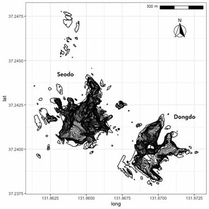
The vascular flora of the Dokdo Islands has been reported, based on primary collections made in 2012 and 2013 and legacy botanical literature. The Dokdo Islands are the remotest islands of Korea, located in the East Sea approximately 87 km from Ulleungdo Islands. They comprise two main volcanic islands, Dongdo (east islands) and Seodo (west islands) and minor islets surrounding the two main islands. This research was conducted to document vascular plant species inhabiting Korea's most inaccessible islands. We present a georeferenced dataset of vascular plant species collected during field studies on the Dokdo Islands over the past seven decades.
New information
In the present inventory of the flora of Dokdo, there are listed 108 species belonging to 78 genera and 39 families, including 93 native species and 15 newly human-induced naturalised species for these Islands' flora. The Poaceae and Asteraceae families are the most diverse, with 22 and 15 taxa, respectively. Some of the previously-listed taxa were not found on Dokdo probably because they are rare and the limited time did not allow collectors to find rare species. The spread of introduced species, especially the invasive grass Bromus catharticus Vahl., affects several native species of Dokdo flora.
Keywords
biodiversity, Bromus catharticus, Dokdo, flora, invasive species, islands, vascular plants
Introduction
Biodiversity researchers have identified critical gaps in spatial, temporal and taxonomic coverage of biodiversity observations highlighting barriers to effective data collection, open access and analysis (
Geographical location and security level are the main factors causing spatial gaps (
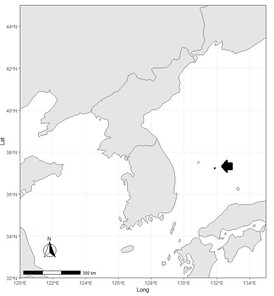
The Dokdo Islands are the most inaccessible islands in Korea, located at
General description
This research focused on the digitisation of plant distribution data on Dokdo Islands acquired by botanists on occasional expeditions to the Islands between 1947 and 2018. These data offer a promising tool to help guide the biodiversity management and conservation of these highly inaccessible island ecosystems.
Project description
Vascular plants occurrences in Dokdo Islands, Korea, based on herbarium collections and legacy botanical literature.
The datasets were digitised by Hui Kim (data manager), Su-Young Jung was the resource creator and Shin Young Kwon, Hyun Tak Shin and Chin-Sung Chang were the content providers. Chin-Sung Chang checked taxonomic changes and georeferencing. S.Y. Jung conducted the field works for two years, from April 2012 to September 2013, collaborating with members from Korea National Arboretum (
The small islands of Dokdo are volcanic rocks formed in the Cenozoic era, more specifically 4.6-2.5 million years ago, having a formation mechanism similar to underwater islands (
Sampling methods
The Dokdo Islands are the most inaccessible islands in Korea, located at
The vascular plant occurrence data, treated in this study, were compiled using fieldwork from 2012 to 2013 and botanical legacy articles from 1947 to 2018. Herbarium surveys were conducted in two Herbaria, including SNUA (Seoul National University, College of Agriculture, herbarium acronym following Index Herbariorum) and KH (Korea National Arboretum). In addition to the authors’ collections, datasets on vascular plant occurrences in Dokdo Islands were digitised from several manuscripts in a heterogeneous format (
Data sources for the dataset of vascular plants occurrences in Dokdo Islands.
|
Data source |
Type of occurrence data |
Number of occurrences |
Field year |
|
|
Literature |
36 |
1947 |
|
|
Literature |
23 |
1958 |
|
|
Herbarium |
37 |
1978 |
|
|
Literature |
69 |
1996-1999 |
|
|
Literature |
49 |
2006 |
|
|
Literature |
49 |
2007 |
|
|
Literature |
57 |
2008 |
|
|
Literature |
58 |
2008-2009 |
|
|
Literature |
60 |
2008-2011 |
|
|
Herbarrium/ Literature |
91 |
2012-2013 |
|
|
Literature |
65 |
2013-2014 |
|
|
Literature |
54 |
2015-2016 |
|
|
Literature |
56 |
2016 |
|
|
Literature |
66 |
2017 |
|
|
Literature |
68 |
2017-2018 |
|
Total |
838 |
The Dokdo Islands occurrence dataset was manually digitised from scanned documents of the original papers. The quality control processes of biodiversity data management were based on the principles of data quality by
1. The content providers carefully reviewed individual floristic publications to manage the irregularity in the format of historical papers. All occurrence records were merged into a spreadsheet, which contained the original species names recorded at the location. In this digitisation stage, obvious typographic errors were corrected. Accepted taxon names and taxonomic classification derived from the local checklist (
2. MS Access was used to create the BRAHMS database layout. All specimen and occurrence information were recorded in the BRAHMS database of the T.B. Lee Herbarium.
3. In the literature data, we frequently encountered several uncertain dates of field works, for instance, 13 July 2017; 26 September 2017; 17 April 2018; 19-20 June 2018; 18 September 2018, for 68 collections by
4. All occurrence records without coordination were georeferenced, either from the coordinates provided in the paper or from the geographic description of the localities. The coordinate uncertainty in metres for each occurrence was estimated employing the algorithm of
5. Occurrence data in BRAHMS could be easily exported in various formats, including Darwin Core for uploading to the EABCN IPT. The Darwin Core standard was applied to the BRAHMS extract/query file structure to accommodate the relevant information extracted from the publications.
Geographic coverage
Dokdo Islands, Ulleung-gun, Geongsangbuk-do, the Republic of Korea (approximately
37.225 and 37.255 Latitude; 131.823 and 131.9 Longitude.
Taxonomic coverage
All vascular plants were identified to infraspecific level. This dataset contains distribution information for 108 vascular plant species belonging to 39 families (Table
Classification of species according to the criteria of Family, Habitat and Geographical origin is based on
|
Number |
SPECIES |
FAMILY |
HABIT |
Geographic Origin |
|
|
1 |
Tetragonia tetragonoides (Pall.) Kuntze |
Aizoaceae |
Herb |
Native |
|
|
2 |
Achyranthes bidentata Blume |
Amaranthaceae |
Herb |
Native |
|
|
3 |
Achyranthes bidentata var. japonica Miq. |
Amaranthaceae |
Herb |
Native |
|
|
4 |
Cnidium japonicum Miq. |
Apiaceae |
Herb |
Native |
|
|
5 |
Oenanthe javanica (Blume) DC. |
Apiaceae |
Herb |
Native |
|
|
6 |
Metaplexis japonica (Thunb.) Makino |
Apocynaceae |
Herb |
Native |
|
|
7 |
Artemisia codonocephala Diels |
Asteraceae |
Herb |
Native |
|
|
8 |
Artemisia indica Willd. |
Asteraceae |
Herb |
Native |
|
|
9 |
Artemisia japonica Thunb. |
Asteraceae |
Herb |
Native |
|
|
10 |
Artemisia koidzumii Nakai |
Asteraceae |
Herb |
Native |
|
|
11 |
Artemisia montana (Nakai) Pamp. |
Asteraceae |
Herb |
Native |
|
|
12 |
Artemisia scoparia Waldst. & Kit. |
Asteraceae |
Herb |
Native |
|
|
13 |
Aster spathulifolius Maxim. |
Asteraceae |
Herb |
Native |
|
|
14 |
Dendranthema naktongense (Nakai) Tzvelev |
Asteraceae |
Herb |
Native |
|
|
15 |
Farfugium japonicum (L.) Kitam. |
Asteraceae |
Herb |
Native |
|
|
16 |
Senecio vulgaris L. |
Asteraceae |
Herb |
Introduced |
|
|
17 |
Sonchus asper (L.) Hill |
Asteraceae |
Herb |
Native |
|
|
18 |
Sonchus brachyotus DC. |
Asteraceae |
Herb |
Native |
|
|
19 |
Sonchus oleraceus L. |
Asteraceae |
Herb |
Native |
|
|
20 |
Taraxacum platycarpum Dahlst. |
Asteraceae |
Herb |
Native |
|
|
21 |
Youngia japonica (L.) DC. |
Asteraceae |
Herb |
Native |
|
|
22 |
Arabis serrata Franch. & Sav. |
Brassicaceae |
Herb |
Native |
|
|
23 |
Arabis stelleri DC. |
Brassicaceae |
Herb |
Native |
|
|
24 |
Brassica juncea (L.) Czern. |
Brassicaceae |
Herb |
Introduced |
|
|
25 |
Capsella bursa-pastoris (L.) Medik. |
Brassicaceae |
Herb |
Native |
|
|
26 |
Lepidium virginicum L. |
Brassicaceae |
Herb |
Introduced |
|
|
27 |
Raphanus sativus L. |
Brassicaceae |
Herb |
Introduced |
|
|
28 |
Campanula punctata Lam. |
Campanulaceae |
Herb |
Native |
|
|
29 |
Lonicera morrowii A.Gray |
Caprifoliaceae |
Shrub |
Native |
|
|
30 |
Dianthus longicalyx Miq. |
Caryophyllaceae |
Herb |
Native |
|
|
31 |
Gypsophila oldhamiana Miq. |
Caryophyllaceae |
Herb |
Native |
|
|
32 |
Sagina japonica (Sw.) Ohwi |
Caryophyllaceae |
Herb |
Native |
|
|
33 |
Sagina maxima A.Gray |
Caryophyllaceae |
Herb |
Native |
|
|
34 |
Stellaria aquatica (L.) Scop. |
Caryophyllaceae |
Herb |
Native |
|
|
35 |
Stellaria media (L.) Vill. |
Caryophyllaceae |
Herb |
Native |
|
|
36 |
Stellaria neglecta Weihe |
Caryophyllaceae |
Herb |
Native |
|
|
37 |
Euonymus hamiltonianus Wall. |
Celastraceae |
Shrub |
Native |
|
|
38 |
Euonymus japonicus Thunb. |
Celastraceae |
Shrub |
Native |
|
|
39 |
Atriplex gmelinii C.A.Mey. ex Bong. |
Chenopodiaceae |
Herb |
Native |
|
|
40 |
Atriplex subcordata Kitag. |
Chenopodiaceae |
Herb |
Native |
|
|
41 |
Chenopodium album L. |
Chenopodiaceae |
Herb |
Native |
|
|
42 |
Chenopodium giganteum D.Don |
Chenopodiaceae |
Herb |
Native |
|
|
43 |
Chenopodium glaucum L. |
Chenopodiaceae |
Herb |
Introduced |
|
|
44 |
Chenopodium stenophyllum (Makino) Koidz. |
Chenopodiaceae |
Herb |
Native |
|
|
45 |
Hypericum erectum Thunb. |
Clusiaceae |
Herb |
Native |
|
|
46 |
Commelina communis L. |
Commelinaceae |
Herb |
Native |
|
|
47 |
Calystegia soldanella (L.) R.Br. |
Convolvulaceae |
Herb |
Native |
|
|
48 |
Ipomoea purpurea (L.) Roth |
Convolvulaceae |
Herb |
Introduced |
|
|
49 |
Phedimus middendorffianus (Maxim.) 't Hart |
Crassulaceae |
Herb |
Native |
|
|
50 |
Sedum japonicum Siebold ex Miq. |
Crassulaceae |
Herb |
Native |
|
|
51 |
Sedum kamtschaticum Fisch. & C.A.Mey. |
Crassulaceae |
Herb |
Native |
|
|
52 |
Sedum oryzifolium Makino |
Crassulaceae |
Herb |
Native |
|
|
53 |
Cucumis melo L. |
Cucurbitaceae |
Herb |
Introduced |
|
|
54 |
Cyperus microiria Steud. |
Cyperaceae |
Herb |
Native |
|
|
55 |
Cyrtomium falcatum (L.f.) C.Presl |
Dryopteridaceae |
Herb |
Native |
|
|
56 |
Elaeagnus macrophylla Thunb. |
Elaeagnaceae |
Liana |
Native |
|
|
57 |
Machilus thunbergii Siebold & Zucc. ex Meisn. |
Lauraceae |
Tree |
Native |
|
|
58 |
Allium fistulosum L. |
Liliaceae |
Herb |
Introduced |
|
|
59 |
Allium macrostemon Bunge |
Liliaceae |
Herb |
Native |
|
|
60 |
Asparagus cochinchinensis (Lour.) Merr. |
Liliaceae |
Herb |
Native |
|
|
61 |
Asparagus schoberioides Kunth |
Liliaceae |
Herb |
Native |
|
|
62 |
Lilium lancifolium Thunb. |
Liliaceae |
Herb |
Native |
|
|
63 |
Liriope muscari (Decne.) L.H.Bailey |
Liliaceae |
Herb |
Native |
|
|
64 |
Maianthemum dilatatum (A.W.Wood) A.Nelson & J.F.Macbr. |
Liliaceae |
Herb |
Native |
|
|
65 |
Hibiscus syriacus L. |
Malvaceae |
Shrub |
Introduced |
|
|
66 |
Cocculus orbiculatus (L.) DC. |
Menispermaceae |
Liana |
Native |
|
|
67 |
Orobanche coerulescens Stephan |
Orobanchaceae |
Herb |
Native |
|
|
68 |
Oxalis corniculata L. |
Oxalidaceae |
Herb |
Native |
|
|
69 |
Oxalis stricta L. |
Oxalidaceae |
Herb |
Native |
|
|
70 |
Corydalis heterocarpa var. japonica (Franch. & Sav.) Ohwi |
Papaveraceae |
Herb |
Native |
|
|
71 |
Pinus thunbergii Parl. |
Pinaceae |
Tree |
Native |
|
|
72 |
Plantago asiatica L. |
Plantaginaceae |
Herb |
Native |
|
|
73 |
Bromus catharticus Vahl |
Poaceae |
Herb |
Introduced |
|
|
74 |
Cleistogenes hackelii (Honda) Honda |
Poaceae |
Herb |
Native |
|
|
75 |
Digitaria ciliaris (Retz.) Koeler |
Poaceae |
Herb |
Native |
|
|
76 |
Digitaria radicosa (J.Presl) Miq. |
Poaceae |
Herb |
Native |
|
|
77 |
Digitaria violascens Link |
Poaceae |
Herb |
Native |
|
|
78 |
Echinochloa crus-galli (L.) P.Beauv. |
Poaceae |
Herb |
Native |
|
|
79 |
Echinochloa oryzoides (Ard.) Fritsch |
Poaceae |
Herb |
Native |
|
|
80 |
Eleusine indica (L.) Gaertn. |
Poaceae |
Herb |
Native |
|
|
81 |
Elymus kamoji (Ohwi) S.L.Chen |
Poaceae |
Herb |
Native |
|
|
82 |
Festuca ovina L. |
Poaceae |
Herb |
Native |
|
|
83 |
Festuca rubra L. |
Poaceae |
Herb |
Native |
|
|
84 |
Imperata cylindrica (L.) Raeusch. |
Poaceae |
Herb |
Native |
|
|
85 |
Miscanthus sinensis Andersson |
Poaceae |
Herb |
Native |
|
|
86 |
Pennisetum glaucum (L.) R.Br. |
Poaceae |
Herb |
Native |
|
|
87 |
Phragmites japonicus Steud. |
Poaceae |
Herb |
Native |
|
|
88 |
Poa annua L. |
Poaceae |
Herb |
Native |
|
|
89 |
Poa pratensis L. |
Poaceae |
Herb |
Native |
|
|
90 |
Puccinellia nipponica Ohwi |
Poaceae |
Herb |
Native |
|
|
91 |
Setaria faberi R.A.W.Herrm. |
Poaceae |
Herb |
Native |
|
|
92 |
Setaria pumila (Poir.) Roem. & Schult. |
Poaceae |
Herb |
Introduced |
|
|
93 |
Setaria viridis (L.) P.Beauv. |
Poaceae |
Herb |
Introduced |
|
|
94 |
Zoysia japonica Steud. |
Poaceae |
Herb |
Native |
|
|
95 |
Fallopia sachalinensis (F.Schmidt) Ronse Decr. |
Polygonaceae |
Herb |
Native |
|
|
96 |
Persicaria longiseta (Bruijn) Kitag. |
Polygonaceae |
Herb |
Native |
|
|
97 |
Polygonum aviculare L. |
Polygonaceae |
Herb |
Native |
|
|
98 |
Rumex crispus L. |
Polygonaceae |
Herb |
Introduced |
|
|
99 |
Rumex japonicus Houtt. |
Polygonaceae |
Herb |
Native |
|
|
100 |
Portulaca oleracea L. |
Portulacaceae |
Herb |
Native |
|
|
101 |
Lysimachia mauritiana Lam. |
Primulaceae |
Herb |
Native |
|
|
102 |
Ranunculus silerifolius H.Lév. |
Ranunculaceae |
Herb |
Native |
|
|
103 |
Rubus phoenicolasius Maxim. |
Rosaceae |
Shrub |
Native |
|
|
104 |
Lycopersicon esculentum Mill. |
Solanaceae |
Herb |
Introduced |
|
|
105 |
Solanum americanum Mill. |
Solanaceae |
Herb |
Introduced |
|
|
106 |
Camellia japonica L. |
Theaceae |
Shrub |
Native |
|
|
107 |
Viola kusanoana Makino |
Violaceae |
Herb |
Native |
|
|
108 |
Ampelopsis glandulosa var. heterophylla (Thunb.) Momiy. |
Vitaceae |
Liana |
Native |
|
Temporal coverage
Sampling was conducted on several occasions in the period between 1947 and 2018.
Usage licence
This work is licensed under a Creative Commons Attribution (CC-BY) 4.0 License.
Data resources
The present project was focused on digitising the data on plant distribution on Dokdo Islands, collected between 1947 and 2018 by botanists taking part in occasional expeditions to the Islands. These data are expected to contribute to the biodiversity management and conservation of these highly inaccessible island ecosystems.
| Column label | Column description |
|---|---|
| occurrenceID | An identifier for the Occurrence (as opposed to a particular digital record of the occurrence). In the absence of a persistent global unique identifier, construct one from a combination of identifiers in the record that will most closely make the occurrenceID globally unique. |
| recordedBy | A list (concatenated and separated) of names of people, groups or organisations responsible for recording the original Occurrence. The primary collector or observer, especially the one who applies a personal identifier (recordNumber), should be listed first. |
| type | The nature or genre of the resource. |
| basisOfRecord | The specific nature of the data record. |
| institutionCode | The name (or acronym) in use by the institution having custody of the object(s) or information referred to in the record. |
| recordNumber | An identifier given to the Occurrence at the time it was recorded. Often serves as a link between field notes and an Occurrence record, such as a specimen collector's number. |
| day | The integer day of the month on which the Event occurred. |
| month | The integer month in which the Event occurred. |
| year | The four-digit year in which the Event occurred, according to the Common Era Calendar. |
| eventDate | The date-time or interval during which an Event occurred. For occurrences, this is the date-time when the event was recorded. Not suitable for a time in a geological context. |
| verbatimEventDate | The verbatim original representation of the date and time information for an Event. |
| country | The name of the country or major administrative unit in which the Location occurs. |
| countryCode | The standard code for the country in which the Location occurs. |
| stateProvince | The name of the next smaller administrative region than country (state, province, canton, department, region etc.) in which the Location occurs. |
| county | The full, unabbreviated name of the next smaller administrative region than stateProvince (county, shire, department etc.) in which the Location occurs. |
| locality | The specific description of the place. Less specific geographic information can be provided in other geographic terms (higherGeography, continent, country, stateProvince, county, municipality, waterBody, island, islandGroup). This term may contain information modified from the original to correct perceived errors or standardise the description. |
| decimalLatitude | The geographic latitude (in decimal degrees, using the spatial reference system given in geodeticDatum) of the geographic centre of a Location. Positive values are north of the Equator, negative values are south of it. Legal values lie between -90 and 90, inclusive. |
| decimalLongitude | The geographic longitude (in decimal degrees, using the spatial reference system given in geodeticDatum) of the geographic centre of a Location. Positive values are east of the Greenwich Meridian, negative values are west of it. Legal values lie between -180 and 180, inclusive. |
| geodeticDatum | The ellipsoid, geodetic datum or spatial reference system (SRS) upon which the geographic coordinates given in decimalLatitude and decimalLongitude are based. |
| coordinateUncertaintyInMeters | The horizontal distance (in metres) from the given decimalLatitude and decimalLongitude describing the smallest circle containing the whole of the Location. Leave the value empty if the uncertainty is unknown, cannot be estimated or is not applicable (because there are no coordinates). Zero is not a valid value for this term. |
| georeferencedBy | A list (concatenated and separated) of names of people, groups or organisations who determined the georeference (spatial representation) for the Location. |
| identifiedBy | A list (concatenated and separated) of names of people, groups or organisations who assigned the Taxon to the subject. |
| scientificName | The full scientific name, with authorship and date information, if known. When forming part of an Identification, this should be the name in lowest level taxonomic rank that can be determined. This term should not contain identification qualifications, which should instead be supplied in the IdentificationQualifier term. |
| kingdom | The full scientific name of the kingdom in which the taxon is classified. |
| phylum | The full scientific name of the phylum or division in which the taxon is classified. |
| class | The full scientific name of the class in which the taxon is classified. |
| order | The full scientific name of the order in which the taxon is classified. |
| family | The full scientific name of the family in which the taxon is classified. |
| taxonomicStatus | The status of the use of the scientificName as a label for a taxon. Requires taxonomic opinion to define the scope of a taxon. Rules of priority then are used to define the taxonomic status of the nomenclature contained in that scope, combined with the expert's opinion. It must be linked to a specific taxonomic reference that defines the concept. |
| acceptedNameUsage | The full name, with authorship and date information, if known, of the currently accepted taxon. |
| vernacularName | A common or vernacular name. |
| genus | The full scientific name of the genus in which the taxon is classified. |
| specificEpithet | The name of the first or species epithet of the scientificName. |
| scientificNameAuthorship | The authorship information for the scientificName formatted according to the conventions of the applicable nomenclaturalCode. |
| infraspecificEpithet | The name of the lowest or terminal infraspecific epithet of the scientificName, excluding any rank designation. |
| taxonRank | The taxonomic rank of the most specific name in the scientificName. |
| nomenclaturalCode | The nomenclatural code (or codes in the case of an ambiregnal name) under which the scientificName is constructed. |
Additional information
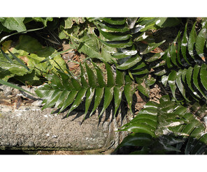
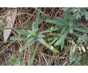
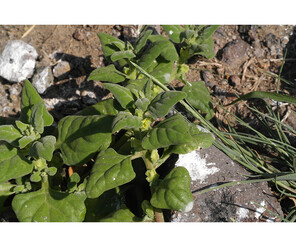
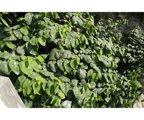
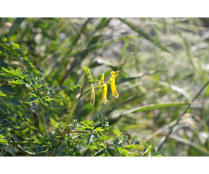
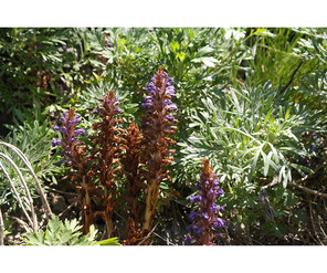
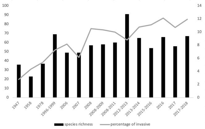
During the seventy years’ observation period (1947-2018), 108 taxa from 39 families were observed. Almost all were flowering plants (only one fern species and one conifer species were recorded), mostly Magnoliopsida (98%). This paper includes 91 specimens and 747 occurrence data of vascular plants recorded in Dokdo Islands regarding 108 taxa identified to infraspecific level. The confirmed species comprise 75 dicots and 31 monocots, one gymnosperm and a non-seed plant (Pteridophytes) species. Most species are native, including Cyrtomium falcatum (L.f.) C.Presl, Dianthus longicalyx Miq., Tetragonia tetragonoides (Pall.) Kuntze, Fallopia sachalinensis (F.Schmidt) Ronse Decr., Lysimachia mauritiana Lam., Sedum oryzifolium Makino, Corydalis heterocarpa var. japonica (Franch. & Sav.) Ohwi and Orobanche coerulescens Stephan (Fig.
Acknowledgements
We are grateful to the Korea National Arboretum for supporting and using the integrated publishing toolkit (IPT) server. This work was supported by grants of BIFA to Chin-Sung Chang (BIFA4_015).
References
- Spatial gaps in global biodiversity information and the role of citizen science.BioScience66(5):393‑400. https://doi.org/10.1093/biosci/biw022
- Best practice guide for data gap analysis for biodiversity stakeholders.GBIF Secretariathttps://doi.org/10.13140/rg.2.2.14018.17608
- Distorted views of iodiversity: spatial and temporal bias in species occurrence data.PLOS Biology8(6). https://doi.org/10.1371/journal.pbio.1000385
- Provisional checklist of Vascular plants for the Korea Peninsula Flora (KPF).Designpost,Seoul. [ISBN978-89-968648-2-0]
- Principles of data quality.Global Biodiversity Information Facilityhttps://doi.org/10.15468/doc.jrgg-a190
- The data paper: a mechanism to incentivize data publishing in biodiversity science.BMC Bioinformatics12https://doi.org/10.1186/1471-2105-12-s15-s2
- Bridging the biodiversity data gaps: Recommendations to meet users’ data needs.Biodiversity Informatics8(2). https://doi.org/10.17161/bi.v8i2.4126
- Spatially explicit data: Stewardship and ethical challenges in science.PLOS Biology11(9). https://doi.org/10.1371/journal.pbio.1001634
- Limitations of biodiversity databases: Case study on seed‐plant diversity in Tenerife, Canary Islands.Conservation Biology21(3):853‑863. https://doi.org/10.1111/j.1523-1739.2007.00686.x
- Historical bias in biodiversity inventories affects the observed environmental niche of the species.Oikos117(6):847‑858. https://doi.org/10.1111/j.0030-1299.2008.16434.x
- Flora of Dokdo. In:Report on the detailed survey of Dokdo ecosystem.Ministry of Environment,Seoul,35-44pp. [InKorean].
- Clay mineral characteristics in volcanic tuffs of Dokdo, South Korea: implication on their genesis and evolution.Environmental Earth Sciences80(7). https://doi.org/10.1007/s12665-021-09583-w
- The study of distribution characteristics of vascular and naturalized plants in Dokdo, South Korea.Journal of Asia-Pacific Biodiversity7(2). https://doi.org/10.1016/j.japb.2014.03.011
- Detailed bathymetry and submarine terraces in the coastal area of the Dokdo Volcano in the Ulleung Basin, the East Sea (Sea of Japan).Journal of Coastal Research65:523‑528. https://doi.org/10.2112/si65-089.1
- Flora of Dokdo. In:Dokdo ecosystem detail survey.National Institute of Ecology,Seochun,66-78pp. [InKorean].
- Vascular plants occurrences in Dokdo islands, Korea, based on herbarium collections and legacy botanical literature.1.10.DMZ Botanic Garden. Release date:2021-11-01. URL: https://www.gbif.org/dataset/37663a11-6c27-4b72-a3bc-75c9dab75a83#citation
- The story of Dokdo’s nature, weather and currents.Gyeongsangbuk-do,Andong,19pp. [InKorean].
- Review of flora of Ullung.Collection of dissertations for Liberal Arts and Science of Korea University3:223‑296. [InKorean].
- Flora of Dokdo. In:Report on monitoring of Dokdo ecosystem.Daegu Local Administration of Environment,Daegu,65-96pp. [InKorean].
- Flora of Dokdo.Nature Conservation22:16‑19. [InKorean].
- Record of plant survey in Dokdo.Fisheries2:26‑31. [InKorean].
- Global priorities for an effective information basis of biodiversity distributions.Nature Communications6:8221. https://doi.org/10.1038/ncomms9221
- Plants of Dokdo. In:Nature of Dokdo.Kyungpook University Press,Daegu,166-210pp. [InKorean].
- The flora of Dokdo monitoring. In:The Dokdo Nature Reserve monitoring 2013.Cultural Heritage Administration,Daegu,10-37pp. [InKorean].
- The flora of Dokdo. In:The Dokdo Nature Reserve sourcebook.Gyeongsangbuk-do,Andong,82-145pp. [InKorean].
- The flora of Dokdo monitoring. In:The Dokdo Nature Reserve monitoring 2017.Cultural Heritage Administration,Daegu,10-39pp. [InKorean].
- The flora and vegetation of Dokdo Island in Ulleung-gun, Gyeongsanbuk-do.Korean Journal of Environmental Ecology24(3):264‑278. [InKorean].
- Flora of Dokdo. In:Dokdo ecosystem detail survey.Daegu Local Administration of Environment,Daegu,9-26pp. [InKorean].
- Strategies and guidelines for scholarly publishing of biodiversity data.Research Ideas and Outcomes3https://doi.org/10.3897/rio.3.e12431
- Guidelines for collection data egistration with BRAHMS 6.National Herbarium Nederland,Leiden,74pp. URL: http://citeseerx.ist.psu.edu/viewdoc/download?doi=10.1.1.718.4755&rep=rep1&type=pdf
- A global assessment of amphibian taxonomic effort and expertise.BioScience60(10):798‑806. https://doi.org/10.1525/bio.2010.60.10.6
- Assessing completeness of biodiversity databases at different spatial scales.Ecography30(1):152‑160. https://doi.org/10.1111/j.0906-7590.2007.04627.x
- Distribution and management of non-indigenous plants in Dokdo.Korean Journal of Plant Taxonomy42(1):98‑107. https://doi.org/10.11110/kjpt.2012.42.1.098
- Biodiversity hotspot for marine invertebrates around the Dokdo, East Sea, Korea: Ecological checklist revisited.Marine Pollution Bulletin119(2):162‑170. https://doi.org/10.1016/j.marpolbul.2017.03.068
- Evolution of endemic vascular plants of Ulleungdo and Dokdo in Korea; floristic and cytotaxonomic characteristics of vascular flora of Dokdo.Korean Journal of Plant Taxonomy32(2):143‑158. https://doi.org/10.11110/kjpt.2002.32.2.143
- Bridging the conservation genetics gap by identifying barriers to implementation for conservation practitioners.Global Ecology and Conservation10:231‑242. https://doi.org/10.1016/j.gecco.2017.04.001
- Unlocking biodiversity data: Prioritization and filling the gaps in biodiversity observation data in Europe.Biological Conservation221:78‑85. https://doi.org/10.1016/j.biocon.2017.12.024
- The point-radius method for georeferencing locality descriptions and calculating associated uncertainty.International Journal of Geographical Information Science18(8):745‑767. https://doi.org/10.1080/13658810412331280211