|
Biodiversity Data Journal :
Taxonomic Paper
|
|
Corresponding author: Theophanis Constantinidis (constgr@biol.uoa.gr)
Academic editor: Lorenzo Peruzzi
Received: 07 Feb 2022 | Accepted: 12 Mar 2022 | Published: 21 Apr 2022
© 2022 Panayiotis Doumas, Katerina Goula, Theophanis Constantinidis
This is an open access article distributed under the terms of the Creative Commons Attribution License (CC BY 4.0), which permits unrestricted use, distribution, and reproduction in any medium, provided the original author and source are credited.
Citation:
Doumas P, Goula K, Constantinidis T (2022) Thirty-two new and noteworthy floristic records from north-eastern Greece. Biodiversity Data Journal 10: e81817. https://doi.org/10.3897/BDJ.10.e81817
|
|
Abstract
Background
The vascular flora of Greece comprises no less than 6,705 vascular plant taxa (species and subspecies, including established aliens) in an area of 131,957 km2. The phytogeographic region of north-east Greece (NE), an area characterised by physiographic diversity, is the richest floristic region in Greece, yet it remains less-explored compared to other regions.
New information
We present an annotated inventory of 32 vascular plant taxa collected predominantly from the East Macedonia and Thrace Regions (Makedonia and Thraki, NE Greece), following fieldwork that took place between 2013 and 2021. In our results, we identify seven new additions to the Greek flora (Aethionema saxatile subsp. rhodopaeum, Anthericum ramosum, Aster amellus, Euphorbia carniolica, Hesperis matronalis subsp. matronalis, Saponaria stranjensis and Silene fetlerii) and 25 new records to the regional Greek flora consisting of mostly rare Balkan endemics of a restricted distribution and presumable conservation priorities. Taxonomic comments are added, where necessary. IUCN threat categories are assigned to certain taxa. Our investigation highlights the importance of the Balkan border areas as a source of new floristic elements for single countries and points to the importance of range-restricted taxa, in addition to single-country endemics, to address plants with a narrow distribution pattern.
Keywords
Balkan countries, endemics, flora, new records, Macedonia, Thrace
Introduction
Greece is a Mediterranean country with a rich flora. According to current estimates, no less than 6,705 vascular plant taxa (species and subspecies, including established aliens) grow in an area of 131,957 km2 (
The territory of Thraki (Thrace) in particular, often reported as a single floristic entity in the early floristic and taxonomic literature (e.g.
As a rule, the border areas of Greece with the countries to the north (Albania, North Macedonia and Bulgaria) are formed by high mountains encompassing natural habitats covered by extensive forests. The north-eastern border area with European Turkey is mostly hilly and of low altitude, sustaining cultivation and stock-farming. The turbulent past of this region and its rugged terrain are some of the parameters responsible for retaining the area less well-explored floristically, compared to other Greek regions. As a result, new biodiversity records from the north continue to enrich the flora of Greece (e.g.
Materials and methods
Our study is based on field collections made between 2013 and 2021. For the identification of the plant specimens and their distinction from related taxa, we used the relevant treatments in basic floristic works, i.e. Flora Europaea (
Taxon treatments
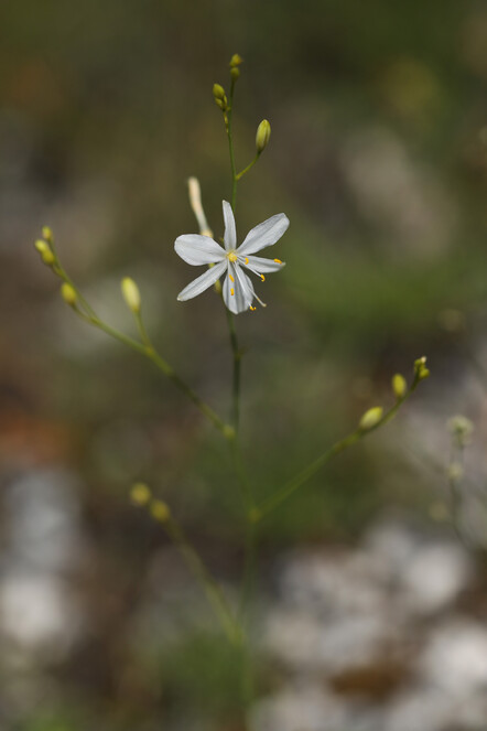
Anthericum ramosum
Nomenclature
Anthericum ramosum L. in Sp. Pl. 1: 310 (1753)
-
scientificName: Anthericum ramosum; family:Anthericaceae; taxonRank:species; genus:Anthericum; specificEpithet:ramosum; continent:Europe; country:Greece; stateProvince:Nomos Dramas; verbatimLocality:Mt. Orvilos, 2 km NE of Katafito Village; verbatimElevation:860 m; verbatimLatitude:41°21′; verbatimLongitude:23°42′; eventDate:4 August 2021; habitat:rocky, calcareous slope; recordedBy:K. Goula & N.A. Katsaros; identifiedBy:K. Goula & Th. Constantinidis; collectionID:3230; institutionCode:ATHU; basisOfRecord:Specimen
Taxon discussion
A new record for the Greek flora. Anthericum ramosum, the generitype of Anthericum L., has a predominantly central European distribution that reaches parts of Russia and Asiatic Turkey to the East (
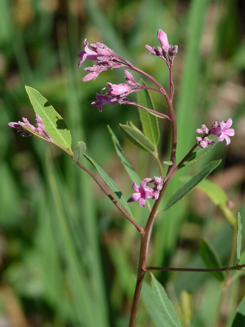
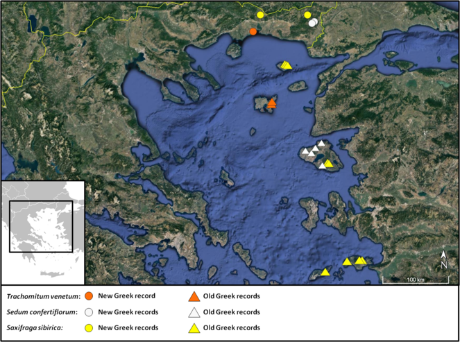
Trachomitum venetum
Nomenclature
Trachomitum venetum (L.) Woodson in Ann. Miss. Bot. Gard. 17: 158 (1930)
-
scientificName: Trachomitum venetum; family:Apocynaceae; taxonRank:species; genus:Trachomitum; specificEpithet:venetum; continent:Europe; country:Greece; stateProvince:Nomos Xanthis; verbatimLocality:Mandra beach, next to a drainage ditch; verbatimElevation:0 m; verbatimLatitude:40°57′; verbatimLongitude:25°00′; eventDate:5 June 2021; habitat:on sandy shore; recordedBy:P. Doumas; identifiedBy:P. Doumas, K. Goula & Th. Constantinidis; collectionID:42; institutionCode:ATHU; basisOfRecord:Specimen
Taxon discussion
This is the second record of the taxonomically difficult genus Trachomitum in Greece (Fig.
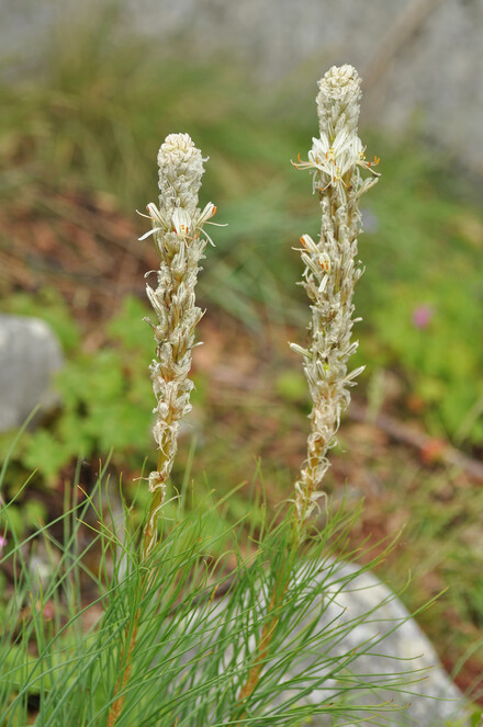
Asphodeline taurica
Nomenclature
Asphodeline taurica (Pall.) Endl. in Cat. Horti Vindob. 1: 142 (1842)
-
scientificName: Asphodeline taurica; family:Asphodelaceae; taxonRank:species; genus:Asphodeline; specificEpithet:taurica; continent:Europe; country:Greece; stateProvince:Nomos Dramas; verbatimLocality:Mt. Orvilos, ca. 1 km SE of the main summit; verbatimElevation:1760 m; verbatimLatitude:41°22′; verbatimLongitude:23°73′; eventDate:29 May 2016; habitat:rocky, calcareous slope; recordedBy:K. Goula; identifiedBy:K. Goula; basisOfRecord:Photograph
-
scientificName: Asphodeline taurica; family:Asphodelaceae; taxonRank:species; genus:Asphodeline; specificEpithet:taurica; continent:Europe; country:Greece; stateProvince:Nomos Kavalas; verbatimLocality:Mt. Pangeo, above abandoned forest settlement; verbatimElevation:1290 m; verbatimLatitude:40°54′; verbatimLongitude:24°08′; eventDate:4 June 2019; habitat:rocky, calcareous slope; recordedBy:K. Goula, U. Gerhard & M. Vlachos; identifiedBy:K. Goula; basisOfRecord:Photograph
-
scientificName: Asphodeline taurica; family:Asphodelaceae; taxonRank:species; genus:Asphodeline; specificEpithet:taurica; continent:Europe; country:Greece; stateProvince:Nomos Xanthis; verbatimLocality:Mt. Achladovouno, 350 m NE of the main summit; verbatimElevation:1300 m; verbatimLatitude:41°10′; verbatimLongitude:24°48′; eventDate:16 May 2021; habitat:rocky, calcareous slope; recordedBy:P. Doumas; identifiedBy:P. Doumas & K. Goula; collectionID:23; institutionCode:ATHU; basisOfRecord:Specimen
Taxon discussion
Scattered in the mountains of north and central Greece, Asphodeline taurica reaches Sterea Ellas and north Peloponnisos to the south, with its southernmost Greek locality on Mt. Chelmos (
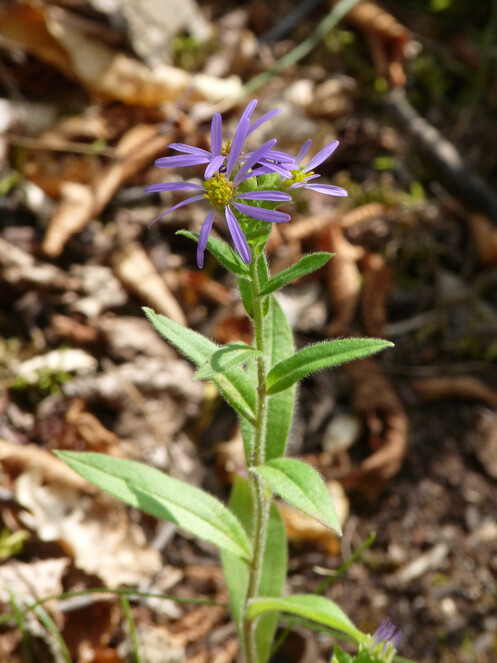
Aster amellus
Nomenclature
Aster amellus L. in Sp. Pl. 2: 873 (1753)
-
scientificName: Aster amellus; family:Asteraceae; taxonRank:species; genus:Aster; specificEpithet:amellus; continent:Europe; country:Greece; stateProvince:Nomos Dramas; verbatimLocality:Mt. Rodopi, ca. 1 km NW of Trachoni settlement; verbatimElevation:753 m; verbatimLatitude:41°21′; verbatimLongitude:24°37′; eventDate:12 September 2021; habitat:Quercus sp. forest, waysides, margins and clearings; recordedBy:P. Doumas; identifiedBy:P. Doumas, K. Goula & Th. Constantinidis; collectionID:59; institutionCode:ATHU; basisOfRecord:Specimen
Taxon discussion
This is a new addition to the Greek flora. Previous old reports are considered erroneous.
The Aster amellus records in Greece have a long history. Old reports from the dry habitats of Attiki near Athens under either A. amellus, as in
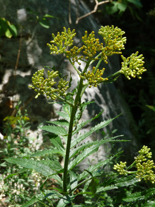
Our collection of Aster amellus from the Rodopi area (Fig.
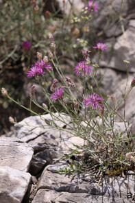
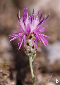
Centaurea marmorea
Nomenclature
Centaurea marmorea Bornm. & Soska in Repert. Spec. Nov. Regni Veg. 42: 127 (1937)
-
scientificName: Centaurea marmorea; family:Asteraceae; taxonRank:species; genus:Centaurea; specificEpithet:marmorea; continent:Europe; country:Greece; stateProvince:Nomos Dramas; verbatimLocality:Mt. Falakro; verbatimElevation:1750 m; verbatimLatitude:40°54′; verbatimLongitude:24°08′; eventDate:3 August 2021; habitat:rocky slopes and road embankments, on marbles; recordedBy:K. Goula & N.A. Katsaros; identifiedBy:K. Goula & Th. Constantinidis; collectionID:3229; institutionCode:ATHU; basisOfRecord:Specimen
Taxon discussion
A rare, local and range-restricted Balkan endemic shared between North Macedonia and Greece. It has been recorded with certainty only from the Prilep area (North Macedonia) and Mt. Orvilos (NE Greece, see
Jacobaea othonnae subsp. anomala
Nomenclature
Jacobaea othonnae subsp. anomala (Sm.) Sutorý in Phytotaxa 510(1): 65 (2021)
-
scientificName: Jacobaea othonnae subsp. anomala; family:Asteraceae; taxonRank:subspecies; genus:Jacobaea; specificEpithet:othonnae; infraspecificEpithet:anomala; continent:Europe; country:Greece; stateProvince:Nomos Xanthis; verbatimLocality:Mt. Achladovouno, NE of the main summit; verbatimElevation:1154 m; verbatimLatitude:41°10′; verbatimLongitude:24°48′; eventDate:9 July 2020; habitat:Fagus sylvatica forest, next to a spring; recordedBy:P. Doumas; identifiedBy:P. Doumas, K. Goula & Th. Constantinidis; collectionID:s.n.; institutionCode:ATHU; basisOfRecord:Specimen
Taxon discussion
Jacobaea othonnae is rare in Greece, known from the floristic regions of North Pindos (NPi) and NE (
Takhtajaniantha austriaca
Nomenclature
Takhtajaniantha austriaca (Willd.) Zaika, Sukhor. & N.Kilian in PhytoKeys 137: 72 (2020) [Scorzonera austriaca Willd.]
-
scientificName: Takhtajaniantha austriaca; family:Asteraceae; taxonRank:species; genus:Takhtajaniantha; specificEpithet:austriaca; continent:Europe; country:Greece; stateProvince:Nomos Xanthis; verbatimLocality:Mt. Achladovouno, just below the summit ridge; verbatimElevation:1332 m; verbatimLatitude:41°10′; verbatimLongitude:24°47′; eventDate:16 May 2021; habitat:rocky, calcareous slopes; recordedBy:P. Doumas; identifiedBy:P. Doumas, K. Goula & Th. Constantinidis; collectionID:29; institutionCode:ATHU; basisOfRecord:Specimen
Taxon discussion
A Euro-Siberian floristic element reported twice in Greece: on the high-altitude serpentine rocks of Mt. Smolikas (
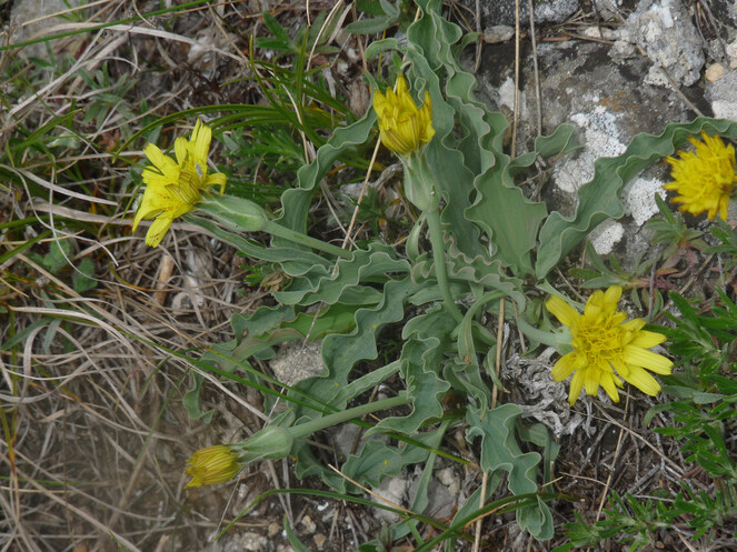
Onosma kittanae
Nomenclature
Onosma kittanae Strid ex Stefanović, Kit Tan & Iatroú in Pl. Syst. Evol. 242(1-4): 157 (2003)
-
scientificName: Onosma kittanae; family:Boraginaceae; taxonRank:species; genus:Onosma; specificEpithet:kittanae; continent:Europe; country:Greece; stateProvince:Nomos Xanthis; verbatimLocality:ca. 2.4 km SE of Potamochori Village; verbatimElevation:553 m; verbatimLatitude:41°14′; verbatimLongitude:25°04′; eventDate:15 May 2021; habitat:scrub, on serpentine; recordedBy:P. Doumas; identifiedBy:P. Doumas & K. Goula; collectionID:19; institutionCode:ATHU; basisOfRecord:Specimen
Taxon discussion
Onosma kittanae was initially described as endemic to Greece (
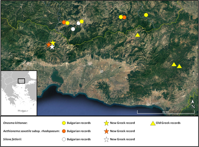
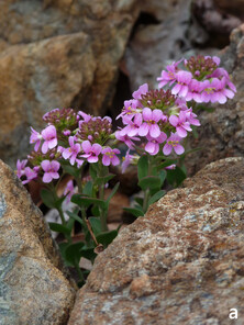
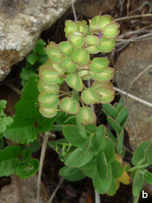
Aethionema saxatile subsp. rhodopaeum
Nomenclature
Aethionema saxatile subsp. rhodopaeum (D.K. Pavlova) Constantinidis, Kougioumoutzis & Kalpoutzakis in Plant Biosyst. 151 (1): 115 (2017)
-
scientificName: Aethionema saxatile subsp. rhodopaeum; family:Brassicaceae; taxonRank:subspecies; genus:Aethionema; specificEpithet:saxatile; infraspecificEpithet:rhodopaeum; continent:Europe; country:Greece; stateProvince:Nomos Xanthis; verbatimLocality:between the Villages of Potamochori and Korifi, close to Kompsatos river belt; verbatimElevation:550 m; verbatimLatitude:41°14′; verbatimLongitude:25°04′; eventDate:27 March 2019; habitat:rocky, serpentine slope with scrub, in deciduous Quercus forest; recordedBy:P. Doumas; identifiedBy:P. Doumas & Th. Constantinidis; collectionID:s.n.; institutionCode:ATHU; basisOfRecord:Specimen
Taxon discussion
A new record for the Greek flora.
As currently understood, Aethionema saxatile (L.) R.Br. is quite variable in Greece. It consists of four subspecies with a more or less distinct geographical distribution that deserve the rank of subspecies (
The cited specimen, collected in Greece in 2019 (Fig.
The following key helps in distinguishing all Αethionema saxatile taxa found in Greece, Table
|
1. A large proportion of fruits (> 30-40%) unilocular. Plants compact, occasionally with a thick woody base up to 1 cm wide; flowering stems usually short, 3-10(-12) cm long |
2 |
|
1a. Unilocular fruits uncommon (< 30-40%) or absent. At least some stems usually longer; plant less compact, woody base thinner |
3 |
|
2. Style (1.7-)2-3(-3.3) mm long, stamens without appendages or appendages rudimentary, petals dark pink-purplish |
subsp. rhodopaeum |
|
2a. Style 0.3-1.1 mm long, stamens with appendages, petals white to pink |
subsp. creticum |
|
3. Unilocular fruits absent; leaves suborbicular to ovate-elliptic, fleshy, less than 3 times as long as wide, up to 23 x 14 mm; petals (4.8-)4.9-7.8(-8) mm long; style length up to 2.1 mm (mean value 1.5 mm) |
subsp. corinthiacum |
|
3a. Unilocular fruits often present; leaves elliptic to oblong, not or slightly fleshy, up to 16 x 8 mm and up to 6 times as long as wide; petals (2.8-)3-6.6(-7.7) mm long; style length shorter than 1.8 mm (mean value 0.5-1.0 mm) |
4 |
|
4. Petals 4-6.6(-7.7) mm long; sepals up to 3.0 mm long; style 0.3-1.6(-1.8) mm long, usually 1.0 mm or longer (mean value 1 mm) |
subsp. graecum |
|
4a. Petals 2.8-4.2(-4.7) mm long; sepals shorter than 2.6 mm long; style (0.2-) 0.3-0.9(-1.1) mm long, very rarely longer than 0.9 mm (mean value 0.5 mm) |
subsp. oreophilum |
Following a morphological and statistical approach, the close taxonomic proximity of subsp. rhodopaeum to the rest of the Ae. saxatile taxa is unquestionable. However, a recent phylogenetic reconstruction places it away from Ae. saxatile as it forms a monophyletic group with the annual Asiatic Ae. syriacum (Boiss.) Bornm. and the perennial Ae. orbiculatum (Boiss.) Hayek, a local endemic of Mt. Athos, Greece (
subsp. rhodopaeum was previously known from a few, small populations in Bulgaria, where it has been assessed as Endangered, according to the IUCN Categories and Criteria (
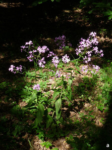
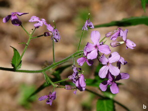
Hesperis matronalis subsp. matronalis
Nomenclature
Hesperis matronalis subsp. matronalis in Sp. Pl. 663 (1753)
-
scientificName: Hesperis matronalis subsp. matronalis; family:Brassicaceae; taxonRank:subspecies; genus:Hesperis; specificEpithet:matronalis; infraspecificEpithet:matronalis; continent:Europe; country:Greece; stateProvince:Nomos Dramas; verbatimLocality:Mt. Rodopi, area of Arkoudorema, ca. 3.6 km NNE of Erimanthos forest village; verbatimElevation:1194 m; verbatimLatitude:41°21′; verbatimLongitude:24°43′; eventDate:27 June 2021; habitat:Fagus sylvatica forest, next to a stream; recordedBy:P. Doumas; identifiedBy:P. Doumas, K. Goula & Th. Constantinidis; collectionID:44; institutionCode:ATHU; basisOfRecord:Specimen
Taxon discussion
Α new subspecies for the Greek flora. Hesperis matronalis is a widespread and variable species divided into 6 or 7 subspecies, of which subsp. cladotricha (Borbás) Hayek has been recorded as a rare plant of the Mt. Timfi area in north-west Greece (
Campanula orphanidea
Nomenclature
Campanula orphanidea Boiss. in Fl. Orient. 3: 897 (1875)
-
scientificName: Campanula orphanidea; family:Campanulaceae; taxonRank:species; genus:Campanula; specificEpithet:orphanidea; continent:Europe; country:Greece; stateProvince:Nomos Xanthis; verbatimLocality:Mt. Achladovouno, the summit area; verbatimElevation:1395 m; verbatimLatitude:41°10′; verbatimLongitude:24°48′; eventDate:4 August 2021; habitat:rocky, calcareous slopes; recordedBy:P. Doumas; identifiedBy:P. Doumas & K. Goula; collectionID:48; institutionCode:ATHU; basisOfRecord:Specimen
Taxon discussion
A local and range-restricted species shared between NE Greece and south Bulgaria. In Greece, it has been reported from the mountains of Athos, Pangeo, Orvilos, Menikio and Falakro, all belonging to the NE floristic region (
Cerastium decalvans subsp. orbelicum
Nomenclature
Cerastium decalvans subsp. orbelicum (Velen.) Stoj. & Stef. in Fl. Bulg.: 416 (1948)
-
scientificName: Cerastium decalvans subsp. orbelicum; family:Caryophyllaceae; taxonRank:subspecies; genus:Cerastium; specificEpithet:decalvans; infraspecificEpithet:orbelicum; continent:Europe; country:Greece; stateProvince:Nomos Xanthis; verbatimLocality:Mt. Achladovouno, ca. 720 m NE of the main summit; verbatimElevation:1170 m; verbatimLatitude:41°10′; verbatimLongitude:24°48′; eventDate:16 May 2021; habitat:rocky, calcareous slope; recordedBy:P. Doumas; identifiedBy:P. Doumas & K. Goula; collectionID:24; institutionCode:ATHU; basisOfRecord:Specimen
-
scientificName: Cerastium decalvans subsp. orbelicum; family:Caryophyllaceae; taxonRank:subspecies; genus:Cerastium; specificEpithet:decalvans; infraspecificEpithet:orbelicum; continent:Europe; country:Greece; stateProvince:Nomos Xanthis; verbatimLocality:Mt. Achladovouno, 840 m NW of the main summit, just below the summit ridge; verbatimElevation:1353 m; verbatimLatitude:41°10′; verbatimLongitude:24°47′; eventDate:4 July 2021; habitat:rocky, calcareous slope; recordedBy:P. Doumas; identifiedBy:P. Doumas & K. Goula; collectionID:53; institutionCode:ATHU; basisOfRecord:Specimen
Taxon discussion
A range-restricted subspecies, endemic to NE Greece, Bulgaria and North Macedonia (
Dianthus petraeus subsp. orbelicus
Nomenclature
Dianthus petraeus subsp. orbelicus (Velen.) Greuter & Burdet in Willdenowia 12: 187 (1982)
-
scientificName: Dianthus petraeus subsp. orbelicus; family:Caryophyllaceae; taxonRank:subspecies; genus:Dianthus; specificEpithet:petraeus; infraspecificEpithet:orbelicus; continent:Europe; country:Greece; stateProvince:Nomos Xanthis; verbatimLocality:Mt. Achladovouno, ca. 700m NE of the main summit; verbatimElevation:1165 m; verbatimLatitude:41°10′; verbatimLongitude:24°48′; eventDate:4 July 2021; habitat:rocky, calcareous slope; recordedBy:P. Doumas; identifiedBy:P. Doumas & K. Goula; collectionID:50; institutionCode:ATHU; basisOfRecord:Specimen
Taxon discussion
This is a range-restricted subspecies, endemic to the eastern part of the Balkan Peninsula. In Greece, it is only known from the mountains of the NE floristic region: Athos, Belles, Pangeo, Menikio, Orvilos, Falakro and Rodopi (
Petrorhagia cretica
Nomenclature
Petrorhagia cretica (L.) P.W. Ball & Heywood in Bull. Brit. Mus. (Nat. Hist.), Bot. 3: 142 (1964)
-
scientificName: Petrorhagia cretica; family:Caryophyllaceae; taxonRank:species; genus:Petrorhagia; specificEpithet:cretica; continent:Europe; country:Greece; stateProvince:Nomos Evrou; verbatimLocality:ca. 5 km N of Avantas Village; verbatimElevation:144 m; verbatimLatitude:40°58′; verbatimLongitude:25°54′; eventDate:1 June 2019; habitat:rocky and gravelly places, on igneous substrates; recordedBy:K. Goula; identifiedBy:K. Goula; collectionID:2881A; institutionCode:ATHU; basisOfRecord:Specimen
Taxon discussion
A very rare species in Greece, having been collected only three times from the floristic regions of North Central (NC), South Pindos (SPi) and Sterea Ellas (StE;
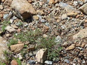
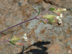
Saponaria stranjensis
Nomenclature
Saponaria stranjensis D. Jord. in God. Sofiisk. Ubiv. Fiz.-Mat. Fak. 30: 400 (1933)
-
scientificName: Saponaria stranjensis; family:Caryophyllaceae; taxonRank:species; genus:Saponaria; specificEpithet:stranjensis; continent:Europe; country:Greece; stateProvince:Nomos Evrou; verbatimLocality:W of Dadia Village, next to the road; verbatimElevation:260 m; verbatimLatitude:41°07′; verbatimLongitude:26°07′; eventDate:4 July 2016; habitat:area surrounded by Pinus forest; recordedBy:P. Doumas; identifiedBy:P. Doumas & Th. Constantinidis; basisOfRecord:Photograph
-
scientificName: Saponaria stranjensis; family:Caryophyllaceae; taxonRank:species; genus:Saponaria; specificEpithet:stranjensis; continent:Europe; country:Greece; stateProvince:Nomos Evrou; verbatimLocality:N of Soufli Town, next to the bank of Kamilopotamos stream; verbatimElevation:34 m; verbatimLatitude:41°12′; verbatimLongitude:26°17′; eventDate:17 August 2019; habitat:Paliurus spina-christi thickets surrounded by mixed Pinus/Quercus forest; recordedBy:P. Doumas; identifiedBy:P. Doumas & Th. Constantinidis; collectionID:s.n.; institutionCode:ATHU; basisOfRecord:Specimen
Taxon discussion
A new record for the Greek flora (Fig.
In Greece, the two species have a clearly different distribution range: S. intermedia extends at the northern parts of Pindos Mountain chain and again found around Mt. Vourinos, at the NW parts of Greece (
Saponaria stranjensis has been assessed as Vulnerable in Bulgaria (
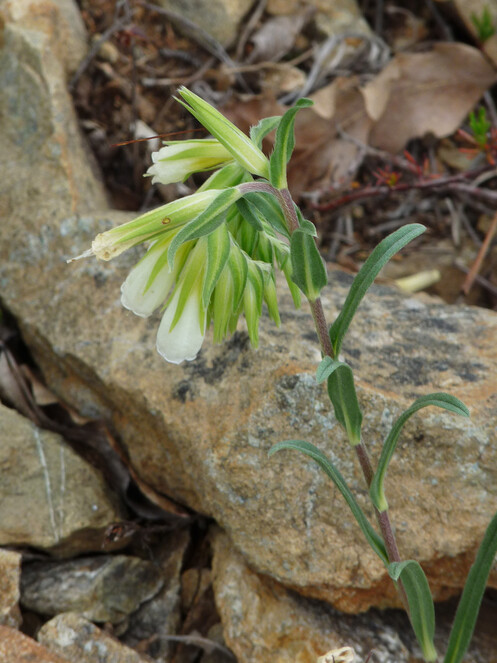
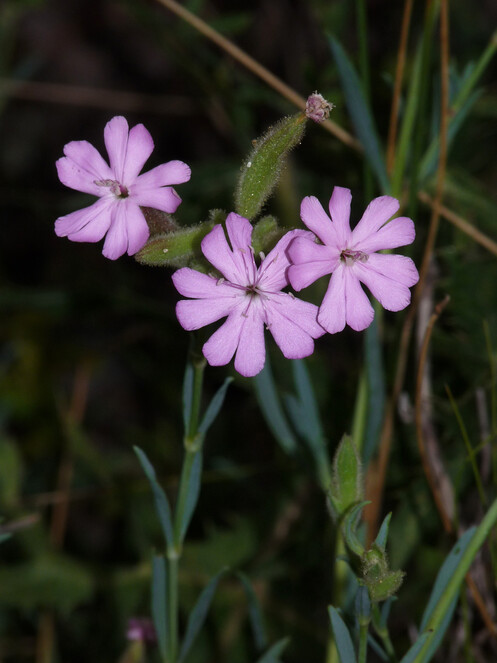
Silene fetlerii
Nomenclature
Silene fetlerii D. Pavlova in Ann. Bot. Fennici 51: 387–393 (2014)
-
scientificName: Silene fetlerii; family:Caryophyllaceae; taxonRank:species; genus:Silene; specificEpithet:fetlerii; continent:Europe; country:Greece; stateProvince:Nomos Xanthis; verbatimLocality:ca. 2.4 km SE of Potamochori Village; verbatimElevation:553 m; verbatimLatitude:41°14′; verbatimLongitude:25°04′; eventDate:15 May 2021; habitat:scrub, on serpentine; recordedBy:P. Doumas; identifiedBy:P. Doumas, K. Goula & Th. Constantinidis; collectionID:18; institutionCode:ATHU; basisOfRecord:Specimen
Taxon discussion
Silene fetlerii is a new addition to the Greek flora.
This is a rare and local species, recently described from Bulgaria and thought to be confined to the serpentine substrates of only two localities, near the Villages of Fotinovo and Chichevo to the south (
This is another species that turns out to cross the political border between Bulgaria and Greece as the new locality lies ca. 12 km south of the border. The new locality expands the known species’ distribution for ca. 25 km to the SW (Fig.
Polygonatum hirtum
Nomenclature
Polygonatum hirtum (Poir.) Pursh in Fl. Amer. Sept. 1: 234 (1813)
-
scientificName: Polygonatum hirtum; family:Convallariaceae; taxonRank:species; genus:Polygonatum; specificEpithet:hirtum; continent:Europe; country:Greece; stateProvince:Nomos Xanthis; verbatimLocality:Mt. Achladovouno, the north-eastern slopes; verbatimElevation:606 m; verbatimLatitude:41°11′; verbatimLongitude:24°48′; eventDate:16 May 2021; habitat:deciduous forest with Carpinus orientalis, limestone; recordedBy:P. Doumas; identifiedBy:P. Doumas & K. Goula; collectionID:25; institutionCode:ATHU; basisOfRecord:Specimen
Taxon discussion
An uncommon and local species in Greece, recorded from the floristic regions of North Central (NC) and North East (NE;
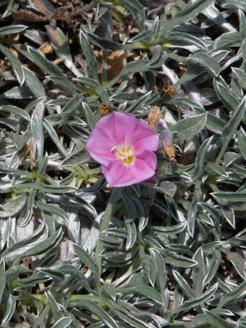
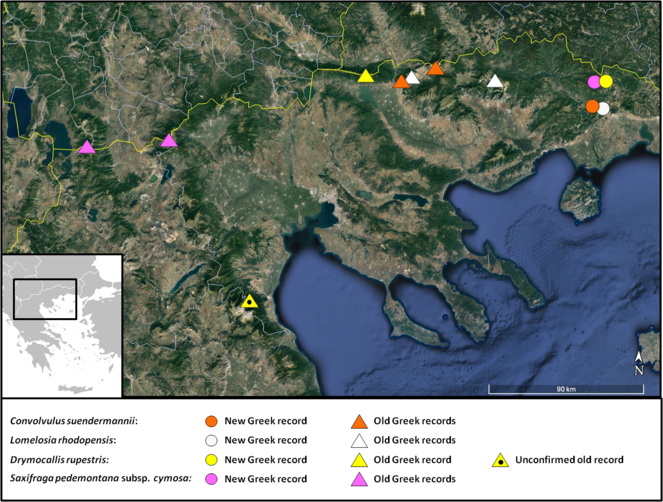
Convolvulus suendermannii
Nomenclature
Convolvulus suendermannii Bornm. in Repert. Spec. Nov. Regni Veg. 43: 152 (1938)
-
scientificName: Convolvulus suendermannii; family:Convolvulaceae; taxonRank:species; genus:Convolvulus; specificEpithet:suendermannii; continent:Europe; country:Greece; stateProvince:Nomos Xanthis; verbatimLocality:Mt. Achladovouno, summit area; verbatimElevation:1395 m; verbatimLatitude:41°10′; verbatimLongitude:24°48′; eventDate:4 July 2021; habitat:rocky, calcareous slope; recordedBy:P. Doumas; identifiedBy:P. Doumas, K. Goula & Th. Constantinidis; collectionID:54; institutionCode:ATHU; basisOfRecord:Specimen
Taxon discussion
A very local and range-restricted species, previously known from the Greek and the Bulgarian sides of Mt. Orvilos (also known as Ali Botuš), although
Sedum confertiflorum
Nomenclature
Sedum confertiflorum Boiss. in Diagn. Pl. Orient. ser. 1, 3: 15 (1843)
-
scientificName: Sedum confertiflorum; family:Crassulaceae; taxonRank:species; genus:Sedum; specificEpithet:confertiflorum; continent:Europe; country:Greece; stateProvince:Nomos Evrou; verbatimLocality:3 km SW of Dadia Village; verbatimElevation:380 m; verbatimLatitude:41°06′; verbatimLongitude:26°11′; eventDate:6 May 2013; habitat:rocky area in opening of Pinus forest; recordedBy:P. Doumas; identifiedBy:P. Doumas & K. Goula; basisOfRecord:Photograph
-
scientificName: Sedum confertiflorum; family:Crassulaceae; taxonRank:species; genus:Sedum; specificEpithet:confertiflorum; continent:Europe; country:Greece; stateProvince:Nomos Evrou; verbatimLocality:8.5 km SW of Dadia Village; verbatimElevation:564 m; verbatimLatitude:41°05′; verbatimLongitude:26°08′; eventDate:3 June 2018; habitat:rocky area, on igneous substrate; recordedBy:K. Goula; identifiedBy:K. Goula; collectionID:2560; institutionCode:ATHU; basisOfRecord:Specimen
-
scientificName: Sedum confertiflorum; family:Crassulaceae; taxonRank:species; genus:Sedum; specificEpithet:confertiflorum; continent:Europe; country:Greece; stateProvince:Nomos Evrou; verbatimLocality:8.5 km SW of Dadia Village; verbatimElevation:564 m; verbatimLatitude:41°05′; verbatimLongitude:26°08′; eventDate:20 June 2019; habitat:rocky area, on igneous substrate; recordedBy:K. Goula; identifiedBy:K. Goula; collectionID:2882; institutionCode:ATHU; basisOfRecord:Specimen
Taxon discussion
An east Mediterranean element previously known from Central and West Anatolia (Turkey) and the Greek Island of Lesvos (
Lomelosia rhodopensis
Nomenclature
Lomelosia rhodopensis (Stoj. & Stef.) Greuter & Burdet in Willdenowia 15(1): 75 (1985)
-
scientificName: Lomelosia rhodopensis; family:Dipsacaceae; taxonRank:species; genus:Lomelosia; specificEpithet:rhodopensis; continent:Europe; country:Greece; stateProvince:Nomos Xanthis; verbatimLocality:Mt. Achladovouno, ca. 300 m NE of the main summit; verbatimElevation:1314 m; verbatimLatitude:41°10′; verbatimLongitude:24°48′; eventDate:4 July 2021; habitat:rocky, calcareous slope; recordedBy:P. Doumas; identifiedBy:P. Doumas & K. Goula; collectionID:51; institutionCode:ATHU; basisOfRecord:Specimen
Taxon discussion
Lomelosia rhodopensis is a rare, range-restricted species endemic to NE Greece and south Bulgaria (
Scabiosa balcanica
Nomenclature
Scabiosa balcanica Velen. in Fl. Bulg. 243 (1891)
-
scientificName: Scabiosa balcanica; family:Dipsacaceae; taxonRank:species; genus:Scabiosa; specificEpithet:balcanica; continent:Europe; country:Greece; stateProvince:Nomos Xanthis; verbatimLocality:Mt. Achladovouno, ca. 550 m NE of the main summit; verbatimElevation:1220 m; verbatimLatitude:41°10′; verbatimLongitude:24°48′; eventDate:4 July 2021; habitat:rocky, calcareous slope; recordedBy:P. Doumas; identifiedBy:P. Doumas & K. Goula; collectionID:52; institutionCode:ATHU; basisOfRecord:Specimen
Taxon discussion
Scabiosa balcanica is a range-restricted Balkan endemic species distributed in Greece, Bulgaria, North Macedonia and Serbia (
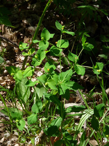
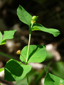
Euphorbia carniolica
Nomenclature
Euphorbia carniolica Jacq. in Fl. Austriac. 5(App.): 34, t. 14 (1778)
-
scientificName: Euphorbia carniolica; family:Euphorbiaceae; taxonRank:species; genus:Euphorbia; specificEpithet:carniolica; continent:Europe; country:Greece; stateProvince:Nomos Xanthis; verbatimLocality:ca. 1.2 km NW of Kotili Village; verbatimElevation:627 m; verbatimLatitude:41°20′; verbatimLongitude:24°52′; eventDate:24 April 2021; habitat:Quercus forest, next to a small stream; recordedBy:P. Doumas; identifiedBy:P. Doumas, K. Goula & Th. Constantinidis; collectionID:5; institutionCode:ATHU; basisOfRecord:Specimen
-
scientificName: Euphorbia carniolica; family:Euphorbiaceae; taxonRank:species; genus:Euphorbia; specificEpithet:carniolica; continent:Europe; country:Greece; stateProvince:Nomos Xanthis; verbatimLocality:ca. 1.2 km NW of Kotili Village; verbatimElevation:627 m; verbatimLatitude:41°20′; verbatimLongitude:24°52′; eventDate:11 May 2021; habitat:Quercus forest, next to a small stream; recordedBy:P. Doumas; identifiedBy:P. Doumas, K. Goula & Th. Constantinidis; collectionID:15; institutionCode:ATHU; basisOfRecord:Specimen
Taxon discussion
A new record for the Greek flora (Fig.
Anthyllis aurea
Nomenclature
Anthyllis aurea Host in Fl. Austriac. 2: 319 (1831)
-
scientificName: Anthyllis aurea; family:Fabaceae; taxonRank:species; genus:Anthylllis; specificEpithet:aurea; continent:Europe; country:Greece; stateProvince:Nomos Xanthis; verbatimLocality:Mt. Achladovouno, just below the summit ridge; verbatimElevation:1343 m; verbatimLatitude:41°10′; verbatimLongitude:24°47′; eventDate:4 July 2021; habitat:rocky, calcareous slope; recordedBy:P. Doumas; identifiedBy:P. Doumas & K. Goula; collectionID:47; institutionCode:ATHU; basisOfRecord:Specimen
Taxon discussion
A Balkan Peninsula endemic known to occur in the northern parts of Greece, with Mt. Pangeo, Mt. Orvilos, Mt. Menikio and Mt. Falakro shaping its distribution to the NE (
Onobrychis alba subsp. calcarea
Nomenclature
Onobrychis alba subsp. calcarea (Vandas) P.W. Ball in Feddes Repert. 79: 41 (1968)
-
scientificName: Onobrychis alba subsp. calcarea; family:Fabaceae; taxonRank:subspecies; genus:Onobrychis; specificEpithet:alba; infraspecificEpithet:calcarea; continent:Europe; country:Greece; stateProvince:Nomos Xanthis; verbatimLocality:Mt. Achladovouno, 600 m NE of the main summit; verbatimElevation:1219 m; verbatimLatitude:41°10′; verbatimLongitude:24°48′; eventDate:4 July 2021; habitat:rocky, calcareous slope; recordedBy:P. Doumas; identifiedBy:P. Doumas & K. Goula; collectionID:49; institutionCode:ATHU; basisOfRecord:Specimen
Taxon discussion
A subspecies endemic to the Balkan Peninsula (
Gladiolus imbricatus
Nomenclature
Gladiolus imbricatus L. in Sp. Pl. 1: 37 (1753)
-
scientificName: Gladiolus imbricatus; family:Iridaceae; taxonRank:species; genus:Gladiolus; specificEpithet:imbricatus; continent:Europe; country:Greece; stateProvince:Nomos Imathias; verbatimLocality:Mt. Vermio, ca. 5.5 km S of Ano Grammatiko Village; verbatimElevation:1374 m; verbatimLatitude:40°40′; verbatimLongitude:21°56′; eventDate:14 July 2018; habitat:wet meadow in opening of mixed Fagus sylvatica-Pinus nigra forest; recordedBy:K. Goula & K. Polymenakos; identifiedBy:K. Goula; collectionID:2704; institutionCode:ATHU; basisOfRecord:Specimen
Taxon discussion
This is a species with an European distribution (
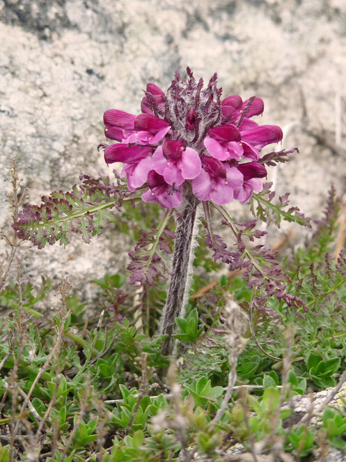
Pedicularis friderici-augusti
Nomenclature
Pedicularis friderici-augusti Tomm. in Linnaea 13(1): 74, t. 2 (1839)
-
scientificName: Pedicularis friderici-augusti; family:Orobanchaceae; taxonRank:species; genus:Pedicularis; specificEpithet:friderici-augusti; continent:Europe; country:Greece; stateProvince:Nomos Xanthis; verbatimLocality:Mt. Achladovouno, 550 m NE of the main summit; verbatimElevation:1223 m; verbatimLatitude:41°10′; verbatimLongitude:24°48′; eventDate:16 May 2021; habitat:rocky, calcareous slope; recordedBy:P. Doumas; identifiedBy:P. Doumas & K. Goula; collectionID:21; institutionCode:ATHU; basisOfRecord:Specimen
Taxon discussion
Endemic to the Balkan Peninsula and Italy (
Pedicularis orthantha
Nomenclature
Pedicularis orthantha Griseb. in Spic. Fl. Rumel. 2(4): 15 (1844)
-
scientificName: Pedicularis orthantha; family:Orobanchaceae; taxonRank:species; genus:Pedicularis; specificEpithet:orthantha; continent:Europe; country:Greece; stateProvince:Nomos Xanthis; verbatimLocality:Mt. Rodopi, area of Koula; verbatimElevation:1565 m; verbatimLatitude:41°19′; verbatimLongitude:24°49′; eventDate:23 May 2021; habitat:rocky places, in openings of forest with Pinus peuce; recordedBy:P. Doumas; identifiedBy:P. Doumas & K. Goula; collectionID:33; institutionCode:ATHU; basisOfRecord:Specimen
Taxon discussion
A range-restricted Balkan endemic with a very limited distribution in Greece, where only two records from the mountains of Voras (NC Greece) and Falakro (NE Greece) are known (
Ranunculus platanifolius
Nomenclature
Ranunculus platanifolius L. in Mantissa 79 (1767)
-
scientificName: Ranunculus platanifolius; family:Ranunculaceae; taxonRank:species; genus:Ranunculus; specificEpithet:platanifolius; continent:Europe; country:Greece; stateProvince:Nomos Grevenon; verbatimLocality:Mt. Vasilitsa, ca. 1 km on the way to Samarina after (NW of) the junction that connects Samarina-Smixi and Smixi-Vassilitsa ski centre roads; verbatimElevation:1642 m; verbatimLatitude:40°03′; verbatimLongitude:21°05′; eventDate:20 June 2020; habitat:damp meadow in Fagus sylvatica forest, serpentine; recordedBy:K. Goula & C. Dimadis; identifiedBy:K. Goula; collectionID:3135; institutionCode:ATHU; basisOfRecord:Specimen
Taxon discussion
Ranunculus platanifolius is widespread in Europe, but in Greece, it is restricted to a few mountains in the north (
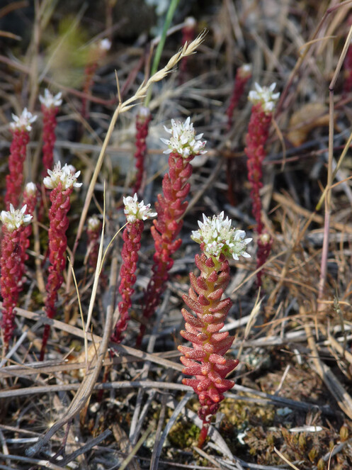
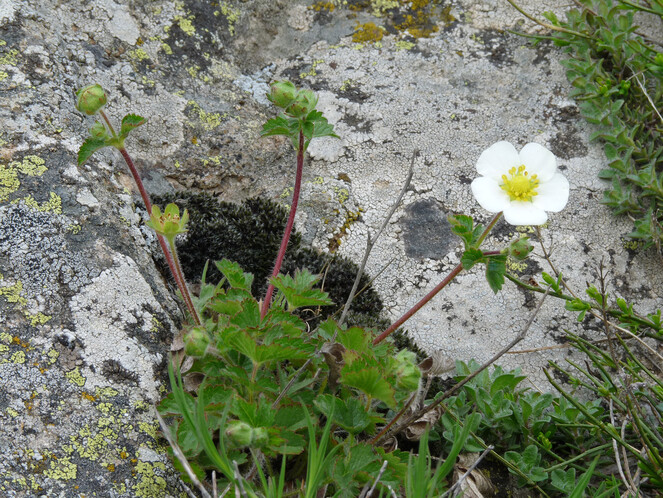
Drymocallis rupestris
Nomenclature
Drymocallis rupestris (L.) Soják in Čas. Nár. Muz. Praze, Rada Přír. 154(3-4): 118 (1989)
-
scientificName: Drymocallis rupestris; family:Rosaceae; taxonRank:species; genus:Drymocallis; specificEpithet:rupestris; continent:Europe; country:Greece; stateProvince:Nomos Xanthis; verbatimLocality:Mt. Rodopi, area of Koula; verbatimElevation:1540 m; verbatimLatitude:41°19′; verbatimLongitude:24°49′; eventDate:23 May 2021; habitat:rocky places, in openings of forest with Pinus peuce; recordedBy:P. Doumas; identifiedBy:P. Doumas, K. Goula & Th. Constantinidis; collectionID:31; institutionCode:ATHU; basisOfRecord:Specimen
Taxon discussion
A very rare species in the Greek territory. There is only one previously confirmed record from Mt. Belles (also known as Mt. Kerkini) by
Saxifraga ferdinandi-coburgi
Nomenclature
Saxifraga ferdinandi-coburgi Kellerer & Sünd. in Allg. Bot. Z. Syst. 1901: 116 (1901)
-
scientificName: Saxifraga ferdinandi-coburgi; family:Saxifragaceae; taxonRank:species; genus:Saxifraga; specificEpithet:ferdinandi-coburgi; continent:Europe; country:Greece; stateProvince:Nomos Xanthis; verbatimLocality:ca. 2.5 km NNW of the abandoned Village of Imera; verbatimElevation:1190 m; verbatimLatitude:41°08′; verbatimLongitude:24°45′; eventDate:30 April 2021; habitat:rocky, calcareous slope facing north; recordedBy:P. Doumas; identifiedBy:P. Doumas & K. Goula; collectionID:9; institutionCode:ATHU; basisOfRecord:Specimen
-
scientificName: Saxifraga ferdinandi-coburgi; family:Saxifragaceae; taxonRank:species; genus:Saxifraga; specificEpithet:ferdinandi-coburgi; continent:Europe; country:Greece; stateProvince:Nomos Xanthis; verbatimLocality:ca. 2.3 km NW of the village of Chrisa; verbatimElevation:787 m; verbatimLatitude:41°08′; verbatimLongitude:24°50′; eventDate:16 April 2020; habitat:rocky, calcareous slope; recordedBy:P. Doumas; identifiedBy:P. Doumas & K. Goula; basisOfRecord:Photograph
-
scientificName: Saxifraga ferdinandi-coburgi; family:Saxifragaceae; taxonRank:species; genus:Saxifraga; specificEpithet:ferdinandi-coburgi; continent:Europe; country:Greece; stateProvince:Nomos Xanthis; verbatimLocality:Mt. Achladovouno, below the summit ridge; verbatimElevation:1341 m; verbatimLatitude:41°10′; verbatimLongitude:24°47′; eventDate:16 May 2021; habitat:rocky, calcareous slope; recordedBy:P. Doumas; identifiedBy:P. Doumas & K. Goula; basisOfRecord:Photograph
Taxon discussion
A range-restricted Balkan endemic species that occurs only in SW Bulgaria and NE Greece. Normally a plant of high altitude (over 1500 m) and reported so far from four Greek mountains (Falakro, Pangeo, Orvilos, Menikio;
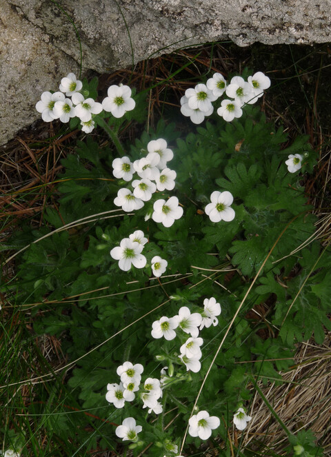
Saxifraga pedemontana subsp. cymosa
Nomenclature
Saxifraga pedemontana subsp. cymosa Engl. in Engl. & Prantl, Nat. Pflan. 3: (2a) 55 (1891)
-
scientificName: Saxifraga pedemontana subsp. cymosa; family:Saxifragaceae; taxonRank:subspecies; genus:Saxifraga; specificEpithet:pedemontana; infraspecificEpithet:cymosa; continent:Europe; country:Greece; stateProvince:Nomos Xanthis; verbatimLocality:Mt. Rodopi, area of Koula; verbatimElevation:1540 m; verbatimLatitude:41°19′; verbatimLongitude:24°49′; eventDate:23 May 2021; habitat:ledges and fissures on north facing cliffs, in openings of forests with Pinus peuce; recordedBy:P. Doumas; identifiedBy:P. Doumas & K. Goula; collectionID:34; institutionCode:ATHU; basisOfRecord:Specimen
Taxon discussion
In Greece, this subspecies is reported only from the floristic region of NC Greece, where it occurs on Mt. Voras (also known as Kaimaktsalan) and Mt. Varnous (
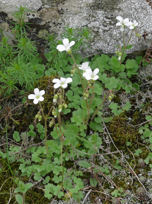
Saxifraga sibirica
Nomenclature
Saxifraga sibirica L. in Syst. Nat., ed. 10. 2: 1027 (1759)
-
scientificName: Saxifraga sibirica; family:Saxifragaceae; taxonRank:species; genus:Saxifraga; specificEpithet:sibirica; continent:Europe; country:Greece; stateProvince:Nomos Rodopis; verbatimLocality:near abandoned settlement of Astrea; verbatimElevation:370 m; verbatimLatitude:41°13′; verbatimLongitude:25°08′; eventDate:11 April 2021; habitat:damp, shady places on sandstone rocks; recordedBy:P. Doumas; identifiedBy:P. Doumas & K. Goula; collectionID:1; institutionCode:ATHU; basisOfRecord:Specimen
-
scientificName: Saxifraga sibirica; family:Saxifragaceae; taxonRank:species; genus:Saxifraga; specificEpithet:sibirica; continent:Europe; country:Greece; stateProvince:Nomos Evrou; verbatimLocality:ca. 3 km SE of Megalo Derio Village; verbatimElevation:193 m; verbatimLatitude:41°13′; verbatimLongitude:26°03′; eventDate:8 May 2021; habitat:rocky area next to a stream; recordedBy:P. Doumas; identifiedBy:P. Doumas & K. Goula; collectionID:14; institutionCode:ATHU; basisOfRecord:Specimen
Taxon discussion
Saxifraga sibirica is rare in Greece, known only from its insular Aegean part (the Islands of Samothraki, Lesvos, Ikaria and Samos;
Discussion
In this report, we provide new localities for 32 taxa (species or subspecies, see Suppl. material
Half of the taxa included in this report have a very limited distribution in Greece, as they had been reported earlier from one to three localities only. Our new localities extend their distribution either within the Greek territory (e.g. Trachomitum venetum, Jacobaea othonnae subsp. anomala) or expand their total known range (e.g. Convolvulus suendermannii, Onosma kittanae). As such, they are important to the ongoing Red Data List project undertaken by the Hellenic Botanical Society that endeavours to attribute each Greek plant taxonomic entity to an IUCN Category (
Three additional points of interest can be deduced from our report:
a. The areas adjacent to the borders can be promising for new floristic discoveries in Greece and in different countries as well. All the new country records in this work come from a 1.5 to 12 km zone off the border-line. Often, this same zone has a low inhabitant density and the environment retains much of its naturalness. Road network or vehicle accesses may be limited and, therefore, botanical exploration may have been delayed.
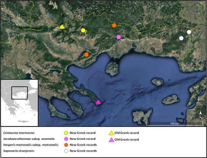
b. When range-restricted plant taxa with a limited area of distribution happen to cross political borders (as, for example, Lomelosia rhodopensis, Saponaria stranjensis and Saxifraga ferdinandi-coburgi in our case), they are no longer considered single country endemics. For plants, political borders certainly have no geographic sense (
c. Compared to high mountains, mountains of average altitude have received less floristic attention in Greece. Mt. Achladovouno (1,402 m at its highest peak) is such a case with 14 of our records coming from its area and forming distribution limits. This Mountain consists almost exclusively of marble (
Acknowledgements
Many thanks to Michael Ristow (University of Potsdam) for allowing access to his Trachomitum collection on Limnos Island, Ute Gerhard and Michalis Vlachos for indicating the Asphodeline taurica locality on Mt. Pangeo, Dionysis Mermygkas (ATH Herbarium) for comparative Centaurea material and Konstantina Koutroumba (BGBM Berlin-Dahlem) for constructive discussions. Four reviewers (Panagiotis Trigas, Francesco Roma-Marzio, Thomas Raus and Panayotis Dimopoulos) improved the final text of the manuscript and are sincerely thanked.
References
- Anthyllis L.In:Mountain Flora of Greece 1.Cambridge University Press,Cambridge,852pp.
- Saxifraga L.In:Flora Hellenica 2.ARG Gantner Verlag KG,Ruggell,511pp.
- A revision of the Aethionema saxatile complex (Brassicaceae).Willdenowia13:3‑42. URL: https://www.jstor.org/stable/3995979
- Anthericum L.In:Mountain Flora of Greece 2.Edinburgh University Press,Edinburgh,1008pp.
- Asphodeline Reichenb.In:Mountain Flora of Greece 2.Edinburgh University Press,Edinburgh,1008pp.
- Conspectus of the Bulgarian vascular flora (4rth edition).Bulgarian Biodiversity Foundation,Sofia,490pp.
- Contributions à “Flora hellenica”: la flore de la région des Monts Timfi (Epire, nord—ouest Grèce) (I).Acta Botanica Gallica140(5):525‑533. https://doi.org/10.1080/12538078.1993.10515629
- Contributions à "Flora Hellenica": la flore de la région des Monts Timfi (Parc national du Vikos-Aoos, Epire, nord-ouest Grèce) (II).Candollea49:483‑497.
- Catalogue commenté de la flore de la région des monts Timfi (parc national du Vikos-Aoos et environs – Epire – Nord-ouest Grèce). 7. Liliaceae.Candollea56:209‑244.
- Reports 1-24. In:New floristic records in the Balkans: 24.Phytologia Balcanica,20 (1): 99-137.
- Report 1. In:New floristic records in the Balkans: 6.Phytologia Balcanica,13 (3): 433-455.
- A biosystematic study of Bellevalia taxa (Hyacinthaceae).PhD Thesis, University of Patras,Patras,194pp. [InGreek with English abstract].
- An updated checklist of the vascular flora native to Italy.Plant Biosystems - An International Journal Dealing with all Aspects of Plant Biology152(2):179‑303. https://doi.org/10.1080/11263504.2017.1419996
- Hesperis matronalis subsp. cladotricha (Borbás) Hayek. In:Med-Checklist Notulae 27.Willdenowia,38 (2): 465-474. https://doi.org/10.3372/wi.38.38207
- Phytodiversity of Limnos (North Aegean, Greece) – an update and evaluation.Flora Mediterranea31:233‑246.
- Flora Orientalis sive enumeratio plantarum in oriente a Graecia et Aegypto ad Indiae fines hucusque observatarum 3.H. George, Genevae et Basileae,Lugduni,1033pp.
- Geological map of Greece. Second edition.Institute of Geology and Mineral Exploration, Athens.
- Sedum L.In:Flora of Turkey and the East Aegean Islands Vol. 4.Edinburgh University Press,Edinburgh,658pp.
- Scorzonera L.In:Flora Europaea Vol. 4.Cambridge University Press,Cambridge,505pp.
- Saponaria L.In:Flora Europaea Vol. 1 (2nd edition).Cambridge University Press,Cambridge,630pp.
- Flora of Turkey and the East Aegean Islands Vol. 1.Edinburgh University Press,Edinburgh,568pp.
- Flora of Turkey and the East Aegean Islands Vol. 2.Edinburgh University Press,Edinburgh,580pp.
- Flora of Turkey and the East Aegean Islands Vol. 3.Edinburgh University Press,Edinburgh,628pp.
- Flora of Turkey and the East Aegean Islands Vol. 4.Edinburgh University Press,Edinburgh,658pp.
- Flora of Turkey and the East Aegean Islands Vol. 5.Edinburgh University Press,Edinburgh,890pp.
- Flora of Turkey and the East Aegean Islands Vol. 6.Edinburgh University Press,Edinburgh,826pp.
- Flora of Turkey and the East Aegean Islands Vol. 7.Edinburgh University Press,Edinburgh,948pp.
- Flora of Turkey and the East Aegean Islands Vol. 8.Edinburgh University Press,Edinburgh,632pp.
- Sedum confertiflorum Boissier. In:Med-Checklist Notulae 29.Willdenowia,40 (2): 189-204. https://doi.org/10.3372/wi.40.40205
- Vascular plants of Greece: An annotated checklist.Botanischer Garten und Botanisches Museum Berlin-Dahlem, Berlin; Hellenic Botanical Society,Athens,372pp.
- Vascular plants of Greece: An annotated checklist. Supplement.Willdenowia46:301‑347. https://doi.org/10.3372/wi.46.46303
- The flora of Greece in numbers.Newsletter of the Hellenic Botanical Society4(2):1‑5. [InGreek].
- Hesperis turkmendaghensis (sect. Hesperis (Cruciferae/Brassicaceae), a new species from the Central Anatolia region, Turkey.Botanical Journal of the Linnean Society147:239‑247. https://doi.org/10.1111/j.1095-8339.2005.00364.x
- Euro+Med PlantBase – the information resource for Euro-Mediterranean plant diversity. URL: http://ww2.bgbm.org/EuroPlusMed/
- Synopsis plantarum florae classicae.EA Fleischmann,München,320pp.
- Centaurea L.In:Mountain Flora of Greece 2.Edinburgh University Press,Edinburgh,1008pp.
- Botanical studies in the Vikos Ravine.lpirotiki Estia228, 229, 230:251‑275. [InGreek].
- Phytogeographical analysis of Euphorbia subgenus Esula (Euphorbiaceae).Polish Botanical Journal60:147‑161. https://doi.org/10.1515/pbj-2015-0024
- Petrorhagia (Ser.) Link. In:Flora Hellenica 1.Koeltz Scientific Books,Königstein,547pp.
- New additions to the Greek flora. Second series.Athens.31 pp.
- Conspectus Florae Graecae Vol. 2.Sumptibus Guilelmi Engelmann,Lipsiae,634pp.
- Gladiolus L.In:Flora Europaea Vol. 5.Cambridge University Press,Cambridge,506pp.
- Sedum L.In:Flora Hellenica 2.ARG Gantner Verlag KG,Ruggell,511pp.
- Campanula L.In:Mountain Flora of Greece 2.Edinburgh University Press,Edinburgh,1008pp.
- Prodromus florae peninsulae balcanicae. Band 1 Pteridophyta, Gymnospermae, Dicotyledoneae (Apetalae et Choripetalae).Repertorium Specierum Novarum Regni Vegetabilis. Centralblatt für Sammlung und Veroffentlichung von Einzeldiagnosen neuer Pflanzen. Beihefte30(1):1‑1201.
- IUCN Red List Categories and Criteria: Version 3.1. Second edition.Gland, Switzerland and Cambridge, UK: IUCN. iv + 32pp.
- Florae Austriacae Vol. V.Josephi Michaelis Gerold, Aulae Imperialis Typographi,Viennae,500pp.
- Atlas Florae Europaeae III.Cambridge University Press,Cambridge, New York, Melbourne,247pp.
- A list of Linnaean generic names and their types.Regnum Veg.127:1‑100.
- Scabiosa L.In:Mountain Flora of Greece 2.Edinburgh University Press,Edinburgh,1008pp.
- Multivariate morphometric analysis and taxa delimitation in two narrow Greek endemics: Astragalus maniaticus and Aethionema saxatile subsp. corinthiacum.Plant Biosystems151(1):108‑116. https://doi.org/10.1080/11263504.2015.1103797
- Scorzonera L.In:Mountain Flora of Greece 2.Edinburgh University Press,Edinburg,1008pp.
- Species Plantarum Tomus 1. Editio secunda.Laurentius Salvius,,Holmiae,784pp.
- Trachomitum Woodson. In:Flora Europaea Vol. 3.Cambridge University Press,Cambridge,370pp.
- Anthericum L.In:Flora of Turkey and the East Aegean Islands Vol 8.Edinburgh University Press,Edinburgh,632pp.
- Zur Kenntnis des Saponaria sicula-Komplexes auf der Balkanhalbinsel.Acta Botanica Croatica35:239‑244.
- Aster L.In:Flora Europaea Vol. 4.Cambridge University Press,Cambridge,505pp.
- Anatolian origins and diversification of Aethionema, the sister lineage of the core Brassicaceae.American Journal of Botany104(7):1042‑1054. https://doi.org/10.3732/ajb.1700091
- Biological flora of Central Europe: Aster amellus L. (Asteraceae).Perspectives in Plant Ecology, Evolution and Systematics13(2):151‑162. https://doi.org/10.1016/j.ppees.2011.03.002
- Floristic investigation of Lemnos Island (NE Aegean area, Greece).Willdenowia33:79‑105. https://doi.org/10.3372/wi.33.33108
- A new species of Aethionema (Brassicaceae) from the Bulgarian flora.Botanical Journal of the Linnean Society155:533‑540. https://doi.org/10.1111/j.1095-8339.2007.00722.x
- Silene fetlerii (Caryophyllaceae), a new species from Bulgaria.Annales Botanici Fennici51:387‑393. https://doi.org/10.5735/085.051.0604
- Red Data Book of the Republic of Bulgaria 1. Plants and fungi.Academy of Sciences & Ministry of Environment and Water,Sofia,881pp.
- Red list of Bulgarian vascular plants.Phytologia Balcanica15(1):63‑94.
- Balkan endemics in the Bulgarian flora.Phytologia Balcanica16(2):293‑311.
- Saponaria L.In:Flora Hellenica 1.Koeltz Scientific Books,Königstein,547pp.
- Pseudo-steppic and aquatic flora of the Natura 2000 network site Limnes Vegoritida-Petron (North-Central Greece).Phytologia Balcanica16(1):109‑129.
- Family Apocynaceae Lindl.In:Flora SSSR, Vol. XVIII, Metachlamydeae.[Translated in English by Landau N (1967) Flora of the USSR, Jerusalem: S. Monson.].621pp.
- Pedicularis L.In:Mountain Flora of Greece 2.Edinburgh University Press,Edinburgh,1008pp.
- Flora Iranica, Apocynaceae, No. 103.Akademische Druck- u. Verlagsanstalt,Graz,23pp.
- Florae Graecae Prodromus Vol. 2.Richardii Taylor et Socii,Londini,427pp.
- Euphorbia L.In:Flora Europaea Vol. 2.Cambridge University Press,Cambridge,455pp.
- Synopsis of Drymocallis Fourr. ex Rydb. (Rosaceae - Potentilleae) in the Old World.Annalen des Naturhistorischen Museums in Wien, SerieB 112:319‑328. URL: http://www.jstor.org/stable/41767487
- Trachomitum Woodson. In:Flora of Turkey and the East Aegean Islands Vol 6.Edinburgh University Press,Edinburgh,826pp.
- Phytogeographic versus political borders: European Union’s Lifelong Learning Programme towards a common concept in the East Aegean (E. Greece, W. Turkey).Fresenius Environmental Bulletin19(4a):696‑703.
- Distribution of the endemic Balkan flora on serpentine I. –obligate serpentine endemics.Plant Syst. Evol.242:149‑170. https://doi.org/10.1007/s00606-003-0044-8
- Chromosome numbers in flowering plants from Greece.Willdenowia13(2):329‑333. URL: https://www.jstor.org/stable/3995848
- Mountain flora of Greece 1.Cambridge University Press,Cambridge,852pp.
- Mountain Flora of Greece 2.Edinburgh University Press,Edinburgh,1008pp.
- Cerastium L.In:Flora Hellenica 1.Koeltz Scientific Books,Königstein,547pp.
- Dianthus L.In:Flora Hellenica 1.Koeltz Scientific Books,Königstein,547pp.
- Flora Hellenica 1.Koeltz Scientific Books,Königstein,547pp.
- Flora Hellenica 2.ARG Gantner Verlag KG,Ruggell,511pp.
- Drymocallis rupestris (L.) Soják. In:Med-Checklist Notulae 31.Willdenowia,42 (2): 287-295. https://doi.org/10.3372/wi.42.42215
- Atlas of the Aegean flora, Part 1: Texts and Plates.Englera 33: 1-700.Botanic Garden and Botanical Museum Berlin, Freie Universität Berlin,Berlin.
- Atlas of the Aegean flora, Part 2: Maps.Englera 33: 1-878.Botanic Garden and Botanical Museum Berlin, Freie Universität Berlin,Berlin.
- Recent progress in plant taxonomy and floristic studies in Greece.Botanica Serbica41(2):123‑152. https://doi.org/10.5281/zenodo.1026649
- Reports 124-148. In:New floristic records in the Balkans: 36.Phytologia Balcanica,24 (2): 263-292.
- Flora and Vegetation of the Prespa National Park, Greece.Society for the Protection of Prespa,Agios Germanos, Prespa,553pp.
- Taxonomic and nomenclatural notes on Jacobaea othonnae (Asteraceae-Senecioneae-Senecioninae).Phytotaxa510(1):61‑68. https://doi.org/10.11646/phytotaxa.510.1.6
- Genus 1462. Aster L. In:Flora of the USSR, Vol. XXV. Compositae.[Translated in English (1999) Bishen Singh Mahendra Pal Singh and Koeltz Scientific Books].574pp.
- Reports 88-95. In:New floristic records in the Balkans: 2.Phytologia Balcanica,12 (2): 279-301.
- Reports 75-84. In:New floristic records in the Balkans: 43.Phytologia Balcanica,26 (3): 537-572.
- Onosma kittanae (Boraginaceae – Lithospermeae).Mitteilungen des Naturwissenschaftlichen Vereines für Steiermark147:77‑97.
- Index herbariorum: a global directory of public herbaria and associated staff. New York Botanical Garden’s Virtual Herbarium. http://sweetgum.nybg.org/science/ih/. Accessed on: 2021-10-01.
- Balkan endemic plants in Central Serbia and Kosovo regions: distribution patterns, ecological characteristics and centres of diversity.Botanical Journal of the Linnean Society176:173‑202. https://doi.org/10.1111/boj.12197
- Institutiones rei herbariae, Tomus Primus.Typographia Regia,Parisiis,779pp.
- A contribution to the phytogeographical classification of the Illyrian floral element.Acta Botanica Croatica5:135‑142.
- Crocus novicii, a new species for the flora of Greece.Parnassiana Archives7:65‑68.
- Flora Europaea Vol. 2.Cambridge University Press,Cambridge,455pp.
- Flora Europaea Vol. 3.Cambridge University Press,Cambridge,370pp.
- Flora Europaea Vol. 4.Cambridge University Press,Cambridge,505pp.
- Flora Europaea Vol. 5.Cambridge University Press,Cambridge,506pp.
- Flora Europaea Vol. 1.Cambridge University Press,Cambridge,630pp.
- Anthericum L.In:Flora Europaea Vol. 5.Cambridge University Press,Cambridge,506pp.
- A foundation monograph of Convolvulus L. (Convolvulaceae).PhytoKeys51:1‑282. https://doi.org/10.3897/phytokeys.51.7104
- Studies in the Apocynaceae. I. A critical study of the Apocynoideae (with special reference to the genus Apocynum).Annals of the Missouri Botanical Garden17:1‑212. https://doi.org/10.2307/2394074
- Proceedings.8th Scientific Congress, Hellenic Botanical Society,Patras,5-8/10/2000.G. I. Petraki,Patras,118-121pp. [InGreek with English abstract].
- Scorzonera sensu lato (Asteraceae, Cichorieae) – taxonomic reassessment in the light of new molecular phylogenetic and carpological analyses.PhytoKeys137:1‑85. https://doi.org/10.3897/phytokeys.137.46544