|
Biodiversity Data Journal :
Taxonomy & Inventories
|
|
Corresponding author: Pedro Jiménez-Mejías (pjimmej@gmail.com), Ana Morales-Alonso (aimoralons@gmail.com)
Academic editor: Arjun Prasad Tiwari
Received: 04 Jan 2023 | Accepted: 18 Feb 2023 | Published: 08 Mar 2023
© 2023 Pedro Jiménez-Mejías, Ana Morales-Alonso, Nora Oleas, Enmily Sánchez, Santiago Martín-Bravo, Irene Masa-Iranzo, Andrea S. Meseguer
This is an open access article distributed under the terms of the Creative Commons Attribution License (CC BY 4.0), which permits unrestricted use, distribution, and reproduction in any medium, provided the original author and source are credited.
Citation:
Jiménez-Mejías P, Morales-Alonso A, Oleas NH, Sánchez E, Martín-Bravo S, Masa-Iranzo I, S. Meseguer A (2023) New relevant chorological and conservation data on Carex (Cyperaceae) and Hypericum (Hypericaceae) from Ecuador. Biodiversity Data Journal 11: e99603. https://doi.org/10.3897/BDJ.11.e99603
|
|
Abstract
Background
Knowledge of Carex L. (true sedges) and Hypericum L. (St. John's wort) in the Neotropics is fragmentary.
New information
As a result of a fieldwork campaign in Ecuador and revision of herbarium collections (K, QCA and QCNE), we present here relevant records of twelve Carex (Cyperaceae) and four Hypericum (Hypericaceae) species. Regarding Carex, we present the novel report for South America of C. aztecica, as well as the first Ecuadorian records for C. brehmeri, C. collumanthus, C. fecunda, C. melanocystis and C. punicola. The three later records have additional biogeographical significance, as they represent the new northern limit of these species. We also include observations for another five species included in the Ecuadorian Red List of Endemic Plants. As a result, the list of native Carex reported for Ecuador would now include 52 taxa. With regard to Hypericum, we include the new report of H. sprucei for the province of Bolívar, and the confirmation of the presence of three rare species (H. acostanum, H. matangense, H. prietoi) in their type localities, although with extremely low population sizes. We discuss their conservation status and implications.
Keywords
Andes, chorology, cordillera, endangered species, flora, páramo
Introduction
Carex L. (true sedges), is one of the three most diverse plant genera in the World, with more than 2000 species (
With over 600 species, Hypericum L. is one of the 100 largest angiosperm genera (
As a result of an international collaboration between the Universidad Autónoma de Madrid (UAM, Madrid, Spain), the Universidad Pablo de Olavide (UPO, Seville, Spain), the Real Jardín Botánico (RJB-CSIC, Madrid, Spain) and the Universidad Tecnológica Indoamérica (UTI, Quito, Ecuador), a fieldwork campaign focusing on Carex and Hypericum was carried out in the Ecuadorian Andes from Loja to Carchi provinces during the summer of 2022. In addition, the complete Carex and Hypericum collections of the two main national Ecuadorian herbaria, QCA and QCNE (acronyms according to
Materials and methods
The complete Carex and Hypericum collections of QCA (Herbario de la Pontificia Universidad Católica del Ecuador) and QCNE (Herbario Nacional del Ecuador (QCNE) del Instituto Nacional de Biodiversidad (INABIO), as well as the complete South American Carex collection of K (Royal Botanic Gardens, Kew) were studied in situ. Herbarium specimens from field collections were deposited at HUTI (Herbario de la Universidad Tecnológica Indoamérica), MA (Herbario del Real Jardín Botánico de Madrid, CSIC) and UPOS (Herbario de la Universidad Pablo de Olavide).
Carex specimens were determined using the specialised literature cited for taxon. Species are presented in alphabetical order according to the accepted names provided by
Hypericum species are listed in alphabetical order according to the accepted names provided by Robson in Studies in the genus Hypericum (
Comments for species included in the Red List of the Endemic Plants of Ecuador (
Taxon treatments
Carex acutata
Nomenclature
=Carex tessellata Spruce ex C.B.Clarke, Bull. Misc. Inform. Kew, Addit. Ser. 8: 86 (1908).
Taxon discussion
Carex acutata is a member of the Hirta Clade (subg. Carex), a lineage with its highest diversity in the Holarctic, but with regional diversification in South America (P. Jiménez-Mejías, pers. obs.). It is distributed in montane and high elevation páramo habitats of the Tropical Andes, from Bolivia to Venezuela.
The name Carex tessellata was included in the Ecuadorian Red List as a “mysterious species known from a single collection of uncertain precedence”. The name was synonymised by
Carex aztecica
-
scientificNameID: Carex aztecica Mack; country:Ecuador; locality:Cotopaxi. La Maná – Latacunga; verbatimElevation:1200 m; locationRemarks:Cotopaxi. La Maná – Latacunga km 26,; georeferenceProtocol:
79°07’W 00°52’S , 1200 m, rocky roadbankslabel; eventDate:7 Apr 1993; catalogNumber:QCA 36385; recordedBy:S. Lægaard; occurrenceID:QCA 36385 -
scientificNameID: Carex aztecica Mack; country:Ecuador; locality:Cotopaxi. La Maná – Latacunga; verbatimElevation:1201 m; locationRemarks:Cotopaxi. La Maná – Latacunga km 26,; georeferenceProtocol:
79°07’W 00°52’S , 1200 m, rocky roadbankslabel; eventDate:7 Apr 1993; catalogNumber:QCNE 124910; recordedBy:S. Lægaard; occurrenceID:QCNE 124910
Taxon discussion
Carex aztecica was hitherto considered a Mesoamerican endemic species, known from southern Mexico and Guatemala. It belongs to the problematic Decora Clade (subg. Carex), where it was included as part of the variation of sect. Indicae Tuckerman sensu lato, a set of species with lax paniculate inflorescences and utriculiform cladoprophylls. The Decora clade is one of the two groups of Carex that are exclusively distributed in tropical-subtropical areas, along with sect. Fecundae Kük. (see below).
The records that we present here are the first for Ecuador, but also for South America. In addition, they constitute the new known southernmost limit of the species. The taxon can be distinguished from the closely related C. polystachya Wahlenb. by its darker female glumes (purple-brown to dark-brown in C. aztecica vs. orange, pale reddish-brown, stramineous or hyaline in C. polystachya) with blunter apex (at least some glumes obtuse or acute vs. all glumes acuminate to awned) and the utricles with the beak reddish-tinged (vs. not tinged) (
Carex brehmeri
-
scientificName: Carex brehmeri Boeckeler; country:Ecuador; stateProvince:Imbabura; verbatimLocality:Volcán Cotacachi, vía a las lagunas de Piñan; verbatimElevation:3838 m; locationRemarks:Imbabura. Volcán Cotacachi, vía a las lagunas de Piñán, 3838 m; georeferenceProtocol:label; verbatimEventDate:21 Jan 2009; catalogNumber:QCA 238505; recordNumber:800; recordedBy:S. Salgado; basisOfRecord:PreservedSpecimen; occurrenceID:QCA 238505
Taxon discussion
Carex brehmeri is a poorly known Andean taxon, reported from isolated locations in Venezuela, Colombia, Peru and Bolivia (
We provide the first record of this small plant from Ecuador. Despite the fact that it might actually be a mere small form of C. enneastachya (see
Carex collumanthus
-
scientificName: Carex collumanthus (Steyerm.) L.E.Mora; country:Ecuador; stateProvince:Carchi; locality:Chiles volcano; verbatimElevation:4300-4400 m; locationRemarks:Carchi. Chiles volcano, SW side.; georeferenceProtocol:
0°48'N 77°57'W , 4300-4400 m, humid superpáramo on shallow sandy soil with rockslabel; eventDate:Jun-21-1995; habitat:humid superpáramo on shallow sandy soil with rocks; catalogNumber:QCA 36562; recordNumber:705; recordedBy:P. Sklenář & V. Kostečková; basisOfRecord:PreservedSpecimen; occurrenceID:QCA 36562 -
scientificName: Carex collumanthus (Steyerm.) L.E.Mora; country:Ecuador; stateProvince:Chimborazo; locality:El Altar volcano; verbatimElevation:4200-4400 m; locationRemarks:Chimborazo. El Altar volcano, N side.; georeferenceProtocol:
1°41'S 78°24'W , 4200-4400 m, humid cushion superpáramo with scattered bunchgrasses on the ridge below the Canoningo peaklabel; eventDate:19 Aug 1995; habitat:humid cushion superpáramo with scattered bunchgrasses on the ridge below the Canoningo peak; catalogNumber:QCA 36510; recordNumber:1045; recordedBy:P. Sklenář & V. Kostečková; basisOfRecord:PreservedSpecimen; occurrenceID:QCA 36510 -
scientificName: Carex collumanthus (Steyerm.) L.E.Mora; country:Ecuador; stateProvince:Chimborazo; locality:Chimborazo volcano; verbatimElevation:4300 m; locationRemarks:Chimborazo. Chimborazo volcano, E side.; georeferenceProtocol:
01°28'S 78°46'W , 4300 m, superpáramo vegetation along wet gentle slope dominated by cushions of Werneria humilis, Distichia muscoides, Plantago rigida and Azorella spp.label; eventDate:Jul-03-1997; catalogNumber:QCA 36525; recordNumber:2177; recordedBy:P. Sklenář & V. Kostečková; basisOfRecord:PreservedSpecimen; occurrenceID:QCA 36525 -
scientificName: Carex collumanthus (Steyerm.) L.E.Mora; country:Ecuador; stateProvince:Chimborazo; locality:Chimborazo volcano; verbatimElevation:4300 m; locationRemarks:Chimborazo. Chimborazo volcano, E side.; georeferenceProtocol:
1°28'S 78°46'W , 4300 m, base of the terminal moraine of the mountain, well developed superpáramo with cushions of Werneria humilis, Plantago rigida, Azorella spp. and Azorella aretioideslabel; eventDate:Jul-03-1997; catalogNumber:QCA 36526; recordNumber:2177; recordedBy:P. Sklenář & V. Kostečková; basisOfRecord:PreservedSpecimen; occurrenceID:QCA 36526 -
scientificName: Carex collumanthus (Steyerm.) L.E.Mora; country:Ecuador; stateProvince:Chimborazo; locality:Miraloma; locationRemarks:Chimborazo. Miraloma, old road Guamote-Atillo (ca 30 km from Guamote),; georeferenceProtocol:
02°05'S 78°39'W , transition between grass páramo and superpáramo, 11 Jun 1999, P. Sklenář 7165label; eventDate:Jun-11-1999; habitat:t; catalogNumber:QCA 36603; recordNumber:7165; recordedBy:P. Sklenář & V. Kostečková; basisOfRecord:PreservedSpecimen; occurrenceID:QCA 36603 -
scientificName: Carex collumanthus (Steyerm.) L.E.Mora; country:Ecuador; stateProvince:Chimborazo; locality:Chimborazo volcano; verbatimElevation:4800 m; locationRemarks:Chimborazo. Chimborazo volcano, around lower refugio.; georeferenceProtocol:
01°27'S 78°50'W , 4800 m, dense mats in springlabel; eventDate:Mar-05-1988; habitat:dense mats in spring; catalogNumber:QCA 36602, QCNE 28718; recordNumber:70550; recordedBy:S. Lægaard; basisOfRecord:PreservedSpecimen; occurrenceID:QCA 36602, QCNE 28718 -
scientificName: Carex collumanthus (Steyerm.) L.E.Mora; country:Ecuador; stateProvince:Chimborazo/Morona Santiago; locality:Cerros Yuibug – Pailacajas; verbatimElevation:4330 m; locationRemarks:Chimborazo/Morona Santiago. Cerros Yuibug – Pailacajas, NE side,; georeferenceProtocol:
1°45'S 78°27'W , 4300-4330 m, just below vertical rocks, humid upper superpáramo with cushions of Azorella spp., Werneria humilis, and many mosseslabel; eventDate:Jul-31-1997; catalogNumber:QCA 36539; recordNumber:3038; recordedBy:S. Lægaard; basisOfRecord:PreservedSpecimen; occurrenceID:QCA 36539 -
scientificName: Carex collumanthus (Steyerm.) L.E.Mora; country:Ecuador; stateProvince:Cotopaxi; locality:Cotopaxi volcano; verbatimElevation:4100-4600 m; locationRemarks:Cotopaxi. Cotopaxi volcano, NE side.; georeferenceProtocol:
00°39'S 78°25'W , 4100-4600 m, superpáramo vegetationlabel; eventDate:Jun-28-1999; catalogNumber:QCA 36605; recordNumber:7478; recordedBy:P. Sklenář & V. Kostečková; basisOfRecord:PreservedSpecimen; occurrenceID:QCA 36605 -
scientificName: Carex collumanthus (Steyerm.) L.E.Mora; country:Ecuador; stateProvince:Napo; locality:Antisana volcano; verbatimElevation:4200-4300 m; locationRemarks:Napo. Antisana volcano, NE side.; georeferenceProtocol:
0°27'S 78°08'W , 4200-4300 m, lower superpáramo vegetation along wet rocky escarpments and Distichia muscoides cushion boglabel; eventDate:19 Aug 1997; catalogNumber:QCA 36546; recordNumber:3491; recordedBy:P. Sklenář & V. Kostečková; basisOfRecord:PreservedSpecimen; occurrenceID:QCA 36546 -
scientificName: Carex collumanthus (Steyerm.) L.E.Mora; country:Ecuador; stateProvince:Napo; locality:Páramo de Guamaní; verbatimElevation:4300-4370 m; locationRemarks:Napo. Páramo de Guamaní.; georeferenceProtocol:
00°19'S 78°11'W , 4300-4370 m, humid superpáramolabel; eventDate:Jun-19-1999; habitat:humid superpáramo; catalogNumber:QCA 36604; recordNumber:7286; recordedBy:P. Sklenář & V. Kostečková; basisOfRecord:PreservedSpecimen; occurrenceID:QCA 36604 -
scientificName: Carex collumanthus (Steyerm.) L.E.Mora; country:Ecuador; stateProvince:Pichincha; locality:Cayambe volcano; verbatimElevation:4400-4500 m; locationRemarks:Pichincha. Cayambe volcano, along road to Refugio.; georeferenceProtocol:
00°04'S 77°57'W , 4400-4500 m, in dense mats of Distichia muscoideslabel; eventDate:Mar-01-1988; catalogNumber:QCA 36601; recordNumber:70500; recordedBy:S. Lægaard; basisOfRecord:PreservedSpecimen; occurrenceID:QCA 36601 -
scientificName: Carex collumanthus (Steyerm.) L.E.Mora; country:Ecuador; stateProvince:Pichincha; locality:Rucu Pichincha; verbatimElevation:4500 m; locationRemarks:Pichincha. Rucu Pichincha volcano.; georeferenceProtocol:
0°10'S 78°34'W , 4500 m, NE slope of the volcano, superpáramo vegetation on steep sandy slopes and rockslabel; eventDate:May-18-1995; catalogNumber:QCA 36542; recordNumber:344; recordedBy:P. Sklenář & V. Kostečková; basisOfRecord:PreservedSpecimen; occurrenceID:QCA 36542 -
scientificName: Carex collumanthus (Steyerm.) L.E.Mora; country:Ecuador; stateProvince:Pichincha; locality:Páramo Guamaní; verbatimElevation:4050 m; locationRemarks:Pinchincha. Páramo Guamaní, close to Páramo de la Virgen.; georeferenceProtocol:
0°20'S 78°13'W , 4050 m, moist páramo and springbogslabel; eventDate:Feb-08-1984; habitat:moist páramo and springbogs; catalogNumber:QCA 36600; recordNumber:51313; recordedBy:S. Lægaard; basisOfRecord:PreservedSpecimen; occurrenceID:QCA 36600
Taxon discussion
Carex collumanthus is endemic from the northern half of the cordillera, where it has been reported from Venezuela, Colombia, Peru and Bolivia (
Here, we report the species for the first time in Ecuador, which was somehow expected since the plant is known from Colombia and Peru.
Carex ecuadorensis
Nomenclature
=Uncinia ecuadorensis G.A.Wheeler & Goetgh., Aliso 15: 10 (1997).
-
scientificName: Carex ecuadorensis (G.A.Wheeler & Goetgh.) J.R.Starr; country:Ecuador; stateProvince:Imbabura; locality:National Park Cotacachi; verbatimElevation:3918 m; locationRemarks:Imbabura. Parque Nacional de Cotacachi, camino de las antenas del Cotacachi,; georeferenceProtocol:
00°19.7943'N 078°20.5391'W , 3918 m, acequia en pajonal, cerca del desagüe al caminoGPS; catalogNumber:117ECU-AMA22 (HUTI, UPOS); recordNumber:117; recordedBy:A. Morales Alonso, P. Jiménez Mejías, I. Masa Iranzo & E. Sánchez; identifiedBy:P. Jiménez-Mejías; dateIdentified:2022; basisOfRecord:PreservedSpecimen; occurrenceID:117ECU-AMA22 (HUTI, UPOS)
Taxon discussion
An Ecuadorian endemic that belongs to sect. Uncinia (Pers.) Baill. (subg. Uncinia (Pers.) Peterm.), a mainly Southern Hemisphere group disjunctly distributed between the Neotropic and the SW Pacific. Formerly recognized as its own genus (Uncinia Pers.;
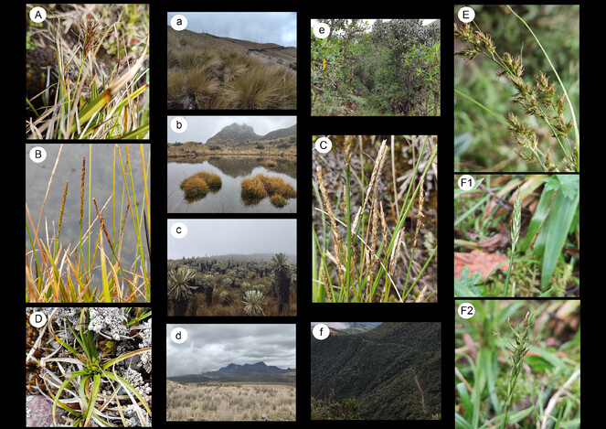
Representative photos of Carex species (capital letters) mentioned in this work and their habitats (small letters). Carex ecuadorensis: (A,a), Imbabura, Parque Nacional de Cotacachi, type locality. Carex madida: (B,b), Pichincha, Parque Nacional Cayambe-Coca, type locality; (C,c), Carchi, Reserva Ecológica El Ángel. Carex punicola: (D,d), Pichincha, Parque Nacional Cotopaxi. Carex sodiroi: (E,e), Pichincha, Reserva Geobotánica Pululahua. Carex subsacculata: (F1,F2,f), Pichincha, Reserva Biológica Yanacocha; the specimen in picture F1 is still inmature, while the one in picture F2 is fully ripe.
Carex ecuadorensis was reported as threatened in the Ecuadorian Red List (as Uncinia ecuadorensis) under the category vulnerable (VU). Known from only two localities collected in the 80s, we confirm its persistence in at least one of these (the type location) and provide an exact location with coordinates. The reported population was found in a natural drainage channel of the pajonal. It was healthy, with about twenty individuals in good conditions. The only direct threat we noticed is the erosion of the slopes next to the road, which was more developed in other sectors. Probably, Carex ecuadorensis is growing in similar habitats in additional places of more difficult access within the same area. In any case, the location of this population in a National Park is an important safeguard for the future persistence of this species.
Carex enneastachya
Nomenclature
= Carex azuayae Steyerm., Phytologia 9: 337 (1963).
-
scientificName: Carex enneastachya C.B.Clarke; country:Ecuador; stateProvince:Cotopaxi; locality:National Park Cotopaxi; verbatimLocality:Limpiopungo; verbatimElevation:3800 m; locationRemarks:Cotopaxi. Parque Nacional Cotopaxi, Limpiopungo,; georeferenceProtocol:
0°40’S 78°0'W , 3800 m, laguna y alrededoreslabel; catalogNumber:QCA 36315, QCNE 3907; recordNumber:2279; recordedBy:H. Balslev; basisOfRecord:PreservedSpecimen; occurrenceID:QCA 36315, QCNE 3907 -
scientificName: Carex enneastachya C.B.Clarke; country:Ecuador; stateProvince:Pichincha; locality:National Park Cotopaxi; verbatimLocality:Laguna Limpiopungo; verbatimElevation:3864 m; locationRemarks:Pichincha. Laguna Limpiopungo, Parque Nacional Cotopaxi,; georeferenceProtocol:
00°36.8748'S 078°25.4262'W , 3864 m, bordes de la laguna y arroyosGPS; catalogNumber:88ECU-AMA22 (HUTI, UPOS); recordNumber:88; recordedBy:A. Morales Alonso, P. Jiménez Mejías & I. Masa Iranzo; identifiedBy:P. Jiménez-Mejías; dateIdentified:2022; basisOfRecord:PreservedSpecimen; occurrenceID:88ECU-AMA22 (HUTI, UPOS) -
scientificName: Carex enneastachya C.B.Clarke; country:Ecuador; stateProvince:Pichincha; locality:National Park Cayambe-Coca; verbatimLocality:Laguna inferior; verbatimElevation:4117 m; locationRemarks:Pinchincha. Laguna inferior. Parque Nacional Cayambe-Coca,; georeferenceProtocol:
00°19.6955'S 078°12.0338'W , 4117 m, turberaGPS; catalogNumber:98ECU-AMA22 (UPOS); recordNumber:98; recordedBy:A. Morales Alonso, P. Jiménez Mejías & I. Masa Iranzo; identifiedBy:P. Jiménez-Mejías; dateIdentified:2022; basisOfRecord:PreservedSpecimen; occurrenceID:98ECU-AMA22 (UPOS) -
scientificName: Carex enneastachya C.B.Clarke; country:Ecuador; stateProvince:Tungurahua; locality:National Park Llanganates; verbatimLocality:laguna Aucacocha; verbatimElevation:3750 m; locationRemarks:Tungurahua. Parque Nacional Llanganates, laguna Aucacocha,; georeferenceProtocol:
01°09’36’’S 78°19’37’’W , 3750 m, orillas de la lagunalabel; eventDate:13 Jan 1999; catalogNumber:QCA 36663; recordNumber:315; recordedBy:E. Terneus & P. Ramsay; basisOfRecord:PreservedSpecimen; occurrenceID:QCA 36663
Taxon discussion
Carex enneastachya is endemic from the Tropical Andes from Colombia to Bolivia. As C. brehmeri, it belongs to sect. Phacocystis Dumort. (see above).
In Ecuador, Carex enneastachya was reported only from a handful locations in Cajas National Park at Azuay Province. Here we present additional records for another three provinces. Originally conceived as a narrowly distributed taxon, this species was listed as EN in the Ecuadorian Red List of Endemic plants under the name C. azuayae. However, C. azuayae was already synonymized by
Carex fecunda
-
scientificName: Carex fecunda Steud.; country:Ecuador; stateProvince:Azuay; locality:National Park Cajas; verbatimLocality:Laguna de Llaviucu; verbatimElevation:3156 m; locationRemarks:Azuay. Laguna de Llaviucu, Parque Nacional Cajas,; georeferenceProtocol:
02°05.6385'S 079°08.9762'W , 3156 m, pastizales húmedos en el borde de lagunaGPS; eventDate:Jul-31-2022; catalogNumber:57ECU-AMA22 (HUTI, UPOS); recordNumber:57; recordedBy:A. Morales Alonso, P. Jiménez Mejías & I. Masa Iranzo; identifiedBy:P. Jiménez-Mejías; dateIdentified:2022; basisOfRecord:PreservedSpecimen; occurrenceID:57ECU-AMA22 (HUTI, UPOS)
Taxon discussion
A South American endemic previously reported from the Central Andes, from Peru to northern Argentina. It belongs to the problematic sect. Fecundae (subg. Carex), a group of sedges entirely diversified within the Neotropic and one of the only two groups of Carex exclusively distributed in tropical-subtropical areas (the other sect. Indicae, see above).
This is the first record for Ecuador and the new northernmost limit for the species. The Ecuadorian specimen had the unusual feature of emitting a profound citric scent from the leaves and stems when crushed that persisted after drying. This aromatic property is known from other sedge groups (e.g. Cyperus odoratus L., C. sesquiflorus (Torr.) Mattf. & Kük.), but it has not been previously reported in Carex, including other fresh or dry C. fecunda specimens (P. Jiménez-Mejías, pers. obs.). This may indicate some differences with respect to other more southern C. fecunda populations and deserves further study.
Carex goetghebeurii
Nomenclature
=Uncinia tenuifolia G.A.Wheeler & Goetgh., Aliso 14: 144 (1995).
Taxon discussion
Another Ecuadorian endemic that belongs to sect. Uncinia (see C. ecuadorensis).
Carex goetghebeurii was reported as threatened (VU category) in the Ecuadorian Red List (as Uncinia tenuifolia). This was based on several collections of the same single population extending along a slope next to a road in Zamora-Chinchipe. We visited one of them (“13 km E of the pass, just before junction with old road”, -3.9764109958906992 S, -79.10201083174987 W) and failed to find it. The location has been transformed into a quarry. This unfortunate finding depicts that this plant is already negatively affected by human activities and reveals the need to confirm the persistence of this population and, if positive, to apply urgent conservation measures.
Carex lepida
-
scientificName: Carex lepida Boott; country:Ecuador; stateProvince:Azuay; locality:National Park Cajas; verbatimLocality:Laguna de Llaviucu; verbatimElevation:3156 m; locationRemarks:Azuay. Laguna de Llaviucu, Parque Nacional Cajas,; georeferenceProtocol:
02°05.6385'S 079°08.9762'W , 3156 m, borde de camino en bosque montanoGPS; eventDate:Jul-31-2022; catalogNumber:54ECU-AMA22 (HUTI, UPOS); recordNumber:54; recordedBy:A. Morales Alonso, P. Jiménez Mejías, I. Masa Iranzo & E. Sánchez; identifiedBy:P. Jiménez-Mejías; dateIdentified:2022; basisOfRecord:PreservedSpecimen; occurrenceID:54ECU-AMA22 (HUTI, UPOS) -
scientificName: Carex lepida Boott; country:Ecuador; stateProvince:Imbabura; verbatimLocality:Southwestern slopes of the volcano Cotacachi, near the road from Cotacachi to Selva Alegre; verbatimElevation:3300-3350 m; locationRemarks:Imbabura. Southwestern slopes of the volcano Cotacachi, near the road from Cotacachi to Selva Alegre,; georeferenceProtocol:
0°21'N 78°26'W , 3300-3350 m, secondary páramo with patches of mountain forestlabel; eventDate:Nov-07-1983; habitat:secondary páramo with patches of mountain forest; catalogNumber:QCA 36473; recordNumber:45617; recordedBy:B. Boysen, B. Eriksen, L.P. Kvist, D. Nissen & J. Korning; basisOfRecord:PreservedSpecimen; occurrenceID:QCA 36473 -
scientificName: Carex lepida Boott; country:Ecuador; stateProvince:Imbabura; verbatimLocality:Road Otavalo-Lagunas de Mojanda; verbatimElevation:3500 m; locationRemarks:Imbabura. Road Otavalo-Lagunas de Mojanda,; georeferenceProtocol:
0°14’N 78°20’W , 3500 m, disturbed mossy forestlabel; eventDate:Oct-21-1995; habitat:disturbed mossy forest; catalogNumber:QCA 36498, QCNE 173344; recordNumber:1197; recordedBy:B. Øllgaard; basisOfRecord:PreservedSpecimen; occurrenceID:QCA 36498, QCNE 173344 -
scientificName: Carex lepida Boott; country:Ecuador; stateProvince:Pichincha; locality:Volcán Pasochoa; verbatimLocality:above house of Fundación Natura; verbatimElevation:2800-3300 m; locationRemarks:Pichincha. Volcán Pasochoa, above house of Fundación Natura,; georeferenceProtocol:
0°27’S 78°31’W , 2800-3300 m, grass-field, mountain forest and páramolabel; eventDate:27 Apr 1985; habitat:grass-field, mountain forest and páramo; catalogNumber:QCA 36435; recordNumber:54171; recordedBy:S. Lægaard; basisOfRecord:PreservedSpecimen; occurrenceID:QCA 36435 -
scientificName: Carex lepida Boott; country:Ecuador; stateProvince:Pichincha; verbatimLocality:Refugio de Vida Silvestre Pasochoa; verbatimElevation:3100-3400 m; locationRemarks:Pichincha. Refugio de Vida Silvestre Pasochoa,; georeferenceProtocol:
0°21’S 78°29’W , 3100-3400 mlabel; eventDate:Feb-23-1992; habitat:bosque nublado con un estrato bajo muy denso; catalogNumber:QCA 36379, QCNE 172674; recordNumber:101411; recordedBy:S. Lægaard; basisOfRecord:PreservedSpecimen; occurrenceID:QCA 36379, QCNE 172674 -
scientificName: Carex lepida Boott; country:Ecuador; stateProvince:Zamora-Chinchipe; locality:Cordillera de Sabanilla; verbatimLocality:cerca de la carretera Jimbura-Zumba; verbatimElevation:3100 m; locationRemarks:Zamora-Chinchipe. Cordillera de Sabanilla, cerca de la carretera Jimbura-Zumba,; georeferenceProtocol:
04°42’41''S 79°26’25''W , 3100 m, bosque nublado con un estrato bajo muy densolabel; eventDate:Oct-23-1996; catalogNumber:QCA 36680, QCNE 154445; recordNumber:s.n; recordedBy:R.Bu & SL; basisOfRecord:PreservedSpecimen; occurrenceID:QCA 36680, QCNE 154445
Taxon discussion
Carex lepida was described in the 19th Century from Pichincha Province and remained known only from the type location until additional records were recently reported from Ecuador, Bolivia and Peru (
Remarkably, the species was listed in the Ecuadorian Red List of Endemic plants as critically endangered (CR), as it was known only from the type location from Pichincha volcano slopes, making its persistence there improbable due to the urban growth of Quito. A previous report of a recent collection also from Pichincha already existed (Pasochoa volcano;
Carex lepida × roalsoniana
-
scientificName: Carex lepida × Carex roalsoniana; country:Ecuador; stateProvince:Azuay; locality:National Park Cajas; verbatimLocality:Laguna de Llaviucu; verbatimElevation:3156 m; locationRemarks:Azuay. Laguna de Llaviucu, Parque Nacional Cajas,; georeferenceProtocol:
02°05.6385'S 079°08.9762'W , 3156 m, borde de camino en bosque montanoGPS; eventDate:Jul-31-2022; catalogNumber:55bECU-AMA22 (HUTI, UPOS); recordNumber:55b; recordedBy:A. Morales Alonso, P. Jiménez Mejías, I. Masa Iranzo & E. Sánchez; identifiedBy:P. Jiménez-Mejías; dateIdentified:2022; basisOfRecord:PreservedSpecimen; occurrenceID:55bECU-AMA22 (HUTI, UPOS)
Taxon discussion
First insights of hybridization amongst species of sect. Wheelerianae. The sampled specimens were co-occurring with the two putative parental species in the area (see comments under C. lepida and C. roalsoniana) and showed intermediate morphological characteristics between them (see
Carex madida
Nomenclature
=Uncinia lacustris G.A.Wheeler, Aliso 14: 141 (1995).
-
scientificName: Carex madida J.R.Starr; country:Ecuador; stateProvince:Carchi; locality:Reserva Ecológica El Ángel; verbatimLocality:carretera a las Lagunas Verdes del Volcán Chiles; locationRemarks:Carchi. Reserva Ecológica El Ángel, carretera a las Lagunas Verdes del Volcán Chiles.; georeferenceProtocol:
00°47.3118'N 077°53.5117W , 3682 m, borde de camino en pajonal con formaciones de Espeletia spp.GPS; eventDate:6 Aug 2022; catalogNumber:110 ECU-AMA22 (HUTI, UPOS); recordNumber:110; recordedBy:Morales Alonso, A., Jiménez Mejías, P., Masa Iranzo, I & Sánchez, E.; identifiedBy:P. Jiménez-Mejías; dateIdentified:2022; basisOfRecord:PreservedSpecimen; occurrenceID:110 ECU-AMA22 (HUTI, UPOS) -
scientificName: Carex madida J.R.Starr; country:Ecuador; stateProvince:Carchi; locality:Reserva Ecológica El Ángel; verbatimLocality:Cantones de Tulcán, Espejo y Mira, en la zona de amortiguamiento de la Reserva Ecológica El Ángel; locationRemarks:Carchi. Cantones de Tulcán, Espejo y Mira, en la zona de amortiguamiento de la Reserva Ecológica El Ángel.; georeferenceProtocol:
00°40'N 77°51W , 3635 m, bosque siempreverde montano alto y páramo de frailejoneslabel; eventDate:Oct-08-2011; catalogNumber:QCA221830; recordNumber:166; recordedBy:V. Yunapanta & S. Chimbolema; basisOfRecord:PreservedSpecimen; occurrenceID:QCA221830 -
scientificName: Carex madida J.R.Starr; country:Ecuador; stateProvince:Carchi; locality:Reserva Ecológica El Ángel; verbatimLocality:Cantón Espejo, parroquia de la Libertad; verbatimElevation:3781 m; locationRemarks:Carchi. Cantón Espejo, parroquia de la Libertad, Reserva Ecológica El Ángel.; georeferenceProtocol:
00°42'N, 77°52'W , 3781 m,label; eventDate:Jun-20-2011; catalogNumber:QCA 221804; recordNumber:397; recordedBy:H. Valles & S. Chimbolema; basisOfRecord:PreservedSpecimen; occurrenceID:QCA 221804 -
scientificName: Carex madida J.R.Starr; country:Ecuador; stateProvince:Chimborazo; locality:Collanes Valley, Páramo de los Altares; locationRemarks:Chimborazo. Collanes Valley, Páramo de los Altares,; georeferenceProtocol:
01°40'S 78°24'W , 3900 m, páramo grasslandlabel; eventDate:Sep-03-1987; catalogNumber:QCA 38381; recordNumber:386; recordedBy:P. Ramsay & P.J. Merrow-Smith; basisOfRecord:PreservedSpecimen; occurrenceID:QCA 38381 -
scientificName: Carex madida J.R.Starr; country:Ecuador; stateProvince:Imbabura; locality:National Park Cotacachi-Cayapas; locationRemarks:Imbabura. Parque Nacional Cotacachi-Cayapas,; georeferenceProtocol:
00°19.79'N 078°20.53'W , 3918 m, acequia en pajonal, cerca del caminoGPS; eventDate:7 Aug 2022; catalogNumber:118 ECU-AMA22 (HUTI, UPOS); recordNumber:118; recordedBy:Morales Alonso, A., Jiménez Mejías, P., Masa Iranzo, I & Sánchez, E.; identifiedBy:P. Jiménez-Mejías; dateIdentified:2022; basisOfRecord:PreservedSpecimen; occurrenceID:118 ECU-AMA22 (HUTI, UPOS) -
scientificName: Carex madida J.R.Starr; country:Ecuador; stateProvince:Pichincha; locality:National Park Cayambe-Coca; verbatimLocality:orillas de una pequeña laguna; locationRemarks:Pichincha. Parque Nacional Cayambe-Coca,; georeferenceProtocol:
00°19.4672'S 078°12.0532'W , 4167 mGPS; eventDate:4 Aug 2022; catalogNumber:96ECU-AMA22 (HUTI, UPOS); recordNumber:96; recordedBy:Morales Alonso, A., Jiménez Mejías, P., Masa Iranzo, I & Sánchez, E.; identifiedBy:P. Jiménez-Mejías; dateIdentified:2022; basisOfRecord:PreservedSpecimen; occurrenceID:96ECU-AMA22 (HUTI, UPOS) -
scientificName: Carex madida J.R.Starr; country:Ecuador; stateProvince:Pichincha; locality:National Park Cayambe-Coca; verbatimLocality:en turbera; locationRemarks:Pichincha. Parque Nacional Cayambe-Coca,; georeferenceProtocol:
00°19.6955'S 078°12.0338'W , 4117 m, en turberaGPS; eventDate:4 Aug 2022; catalogNumber:99ECU-AMA22 (UPOS); recordNumber:99; recordedBy:Morales Alonso, A., Jiménez Mejías, P., Masa Iranzo, I & Sánchez, E.; identifiedBy:P. Jiménez-Mejías; dateIdentified:2022; basisOfRecord:PreservedSpecimen; occurrenceID:99ECU-AMA22 (UPOS) -
scientificNameID: Carex madida J.R.Starr; country:Ecuador; stateProvince:Carchi; locality:Tulcán, Páramo de El Ángel; verbatimElevation:3778 m; locationRemarks:Tulcán, Páramo de El Ángel, 3778 m; georeferenceProtocol:label; catalogNumber:QCA 225822; recordNumber:5799; recordedBy:K. Romoleroux & G. Peyre; collectionID:QCA 225822; occurrenceID:QCA 225822
Taxon discussion
This species belongs to sect. Uncinia (see C. ecuadorensis), which remarkably includes three of the four Ecuadorian endemic Carex species (Fig.
Carex madida was reported as vulnerable (VU) in the Ecuadorian Red List (as Uncinia lacustris), based on the known existence of only three localities, all in protected areas (Cayambe-Coca, Cotacachi-Cayapas and Cotopaxi National Parks) in the provinces of Pichincha, Napo and Imbabura, respectively. Here, we report its presence in two additional provinces (Carchi and Chimborazo) and one addition to a protected area (Reserva Ecológica El Ángel). We confirm its persistence in two of the formerly known localities, where it seems abundant. Since the plants occur in Espeletia formations very close to the Colombian border, it is very likely that this species also occurs in the neighbouring country, from which it has not been reported yet.
Carex melanocystis
-
scientificName: Carex melanocystis É.Desv; country:Ecuador; stateProvince:Bolívar; verbatimLocality:Km 4 on road Los Arenales-Salinas; verbatimElevation:4300 m; locationRemarks:Bolívar. Km 4 on road Los Arenales-Salinas,; georeferenceProtocol:
01°24’S 78°55’W , 4300 m, grass-swardlabel; eventDate:Oct-02-1985; habitat:grass-sward; catalogNumber:QCA 36444, QCNE 141330; recordNumber:55347; recordedBy:S. Lægaard; basisOfRecord:PreservedSpecimen; occurrenceID:QCA 36444, QCNE 141330
Taxon discussion
Carex melanocystis is widely distributed across the Andes, from Tierra del Fuego to the Central Andes of Peru (
These are the first confirmed records of C. melanocystis for Ecuador, which become the northernmost limit of the species.
Carex phalaroides
-
scientificName: Carex phalaroides Kunth; country:Ecuador; stateProvince:Chimborazo; locality:Arenales de Palmira; verbatimElevation:3300 m; locationRemarks:Chimborazo. Arenales de Palmira,; georeferenceProtocol:
02°02’S 78°45’W , 3300 mlabel; eventDate:Jun-26-1988; catalogNumber:QCA 36470; recordNumber:71694; recordedBy:S. Lægaard; basisOfRecord:PreservedSpecimen; occurrenceID:QCA 36470 -
scientificName: Carex phalaroides Kunth; country:Ecuador; stateProvince:Chimborazo; verbatimLocality:Camino a Yaruquies, aproximadamente 15 km a la izquierda, comunidad Cacha Chuyu; verbatimElevation:3600 m; locationRemarks:Camino a Yaruquies, aproximadamente 15 km a la izquierda, comunidad Cacha Chuyu,; georeferenceProtocol:
01°40’S 78° 45’W , 3600 m, bosque de Pinus radiata sobre páramolabel; eventDate:19-20 Jul 1993; catalogNumber:QCNE82136; recordNumber:106; recordedBy:M. Garrison; basisOfRecord:PreservedSpecimen; occurrenceID:QCNE82136 -
scientificName: Carex phalaroides Kunth; country:Ecuador; stateProvince:Loja; verbatimLocality:Cerca de Ramos Urku, carretera Loja-Cuenca; verbatimElevation:2900 m; locationRemarks:Cerca de Ramos Urku, carretera Loja-Cuenca,; georeferenceProtocol:
03°40.5102'S 079°16.0522'W , 2900 m, pastizalGPS; eventDate:Jul-28-2022; catalogNumber:22ECU-AMA22 (UPOS); recordNumber:22; recordedBy:A. Morales Alonso, P. Jiménez Mejías, I. Masa Iranzo & E. Sánchez; identifiedBy:P. Jiménez-Mejías; dateIdentified:2022; basisOfRecord:PreservedSpecimen; occurrenceID:22ECU-AMA22 (UPOS) -
scientificName: Carex phalaroides Kunth; country:Ecuador; stateProvince:Loja; verbatimLocality:Cerca de Ońa; verbatimElevation:2839 m; locationRemarks:Loja. Cerca de Oña,; georeferenceProtocol:
03°30.5420'S 079°10.3658'W , 2839 m, matorral degradado sobre suelos arcillososGPS; eventDate:Jul-28-2022; catalogNumber:28ECU-AMA22 (HUTI, UPOS); recordNumber:28; recordedBy:A. Morales Alonso, P. Jiménez Mejías, I. Masa Iranzo & E. Sánchez; identifiedBy:P. Jiménez-Mejías; dateIdentified:2022; basisOfRecord:PreservedSpecimen; occurrenceID:28ECU-AMA22 (HUTI, UPOS) -
scientificName: Carex phalaroides Kunth; country:Ecuador; stateProvince:Pichincha; verbatimLocality:Subida al cerro Corazón; verbatimElevation:3837 m; locationRemarks:Pichincha. Subida al cerro Corazón,; georeferenceProtocol:
00°34.0922'S 078°39.9008'W , 3837 m, borde camino en matorralGPS; eventDate:4 Aug 22; catalogNumber:92ECU-AMA22 (UPOS); recordNumber:92; recordedBy:A. Morales Alonso, P. Jiménez Mejías & I. Masa Iranzo; identifiedBy:P. Jiménez-Mejías; dateIdentified:2022; basisOfRecord:PreservedSpecimen; occurrenceID:92ECU-AMA22 (UPOS) -
scientificName: Carex phalaroides Kunth; country:Ecuador; stateProvince:Pichincha; verbatimLocality:Subida al cerro Corazón; verbatimElevation:3805 m; locationRemarks:Pichincha. Subida al cerro Corazón,; georeferenceProtocol:
00°34.1401'S 078°39.8770'W , 3805 m, pajonal con matorral, en el camino y borde de caminoGPS; eventDate:4 Aug 22; catalogNumber:94ECU-AMA22 (HUTI, UPOS); recordNumber:94; recordedBy:A. Morales Alonso, P. Jiménez Mejías & I. Masa Iranzo; identifiedBy:P. Jiménez-Mejías; dateIdentified:2022; basisOfRecord:PreservedSpecimen; occurrenceID:94ECU-AMA22 (HUTI, UPOS) -
scientificName: Carex phalaroides Kunth; country:Ecuador; stateProvince:Pichincha; locality:Rucu-Pichincha; verbatimLocality:Camino desde estación final del teleférico (cerro Cruz Loma) al Rucu-Pichincha; verbatimElevation:4078 m; locationRemarks:Pichincha. Camino desde estación final del teleférico (cerro Cruz Loma) al Rucu-Pichincha,; georeferenceProtocol:
00°11.0232'S 078°32.3160'W , 4078 m, borde de camino en pajonalGPS; eventDate:13 Aug 22; catalogNumber:147ECU-AMA22 (UPOS); recordNumber:147; recordedBy:A. Morales Alonso, P. Jiménez Mejías & I. Masa Iranzo; identifiedBy:P. Jiménez-Mejías; dateIdentified:2022; basisOfRecord:PreservedSpecimen; occurrenceID:147ECU-AMA22 (UPOS) -
scientificName: Carex phalaroides Kunth; country:Ecuador; stateProvince:Tungurahua; locality:National Park Llanganates; verbatimLocality:Carretera del Parque Nacional Llanganates; verbatimElevation:3577 m; locationRemarks:Tungurahua. Carretera del Parque Nacional Llanganates,; georeferenceProtocol:
01°04.8339'S 078°24.5341'W , 3577 m, praderaGPS; eventDate:2 Aug 22; catalogNumber:79ECU-AMA22 (UPOS); recordNumber:74; recordedBy:A. Morales Alonso, P. Jiménez Mejías & I. Masa Iranzo; identifiedBy:P. Jiménez-Mejías; dateIdentified:2022; basisOfRecord:PreservedSpecimen; occurrenceID:79ECU-AMA22 (UPOS) -
scientificName: Carex phalaroides Kunth; country:Ecuador; stateProvince:Tungurahua; locality:National Park Llanganates; verbatimLocality:Carretera del Parque Nacional Llanganates; verbatimElevation:3617 m; locationRemarks:Tungurahua. Carretera Parque Nacional Llanganates,; georeferenceProtocol:
01°04.6880'S 078°25.6385'W , 3617 m, pastizalGPS; eventDate:2 Aug 22; catalogNumber:74ECU-AMA22 (UPOS); recordNumber:79; recordedBy:A. Morales Alonso, P. Jiménez Mejías & I. Masa Iranzo; identifiedBy:P. Jiménez-Mejías; dateIdentified:2022; basisOfRecord:PreservedSpecimen; occurrenceID:74ECU-AMA22 (UPOS)
Taxon discussion
Carex phalaroides is a Neotropical endemic widely distributed from northern Patagonia to Colombia and Venezuela, with an isolated occurrence known in Guatemala (
Previously known from just a handful locations in Ecuador, our field campaign has resulted in the collection of several additional populations; thus, Carex phalaroides seems to be more widely distributed along Ecuadorian high Andean grasslands. However, to date, it has been collected just a few times (see comments under General considerations at the end of the manuscript), as depicted by its scarce representation in herbaria (just one additional specimen from Ecuador: MO-5869195, Imbabura, Cotacachi-Cayapas, after revising the full collections of K, NY, MO and US).
Carex punicola
-
scientificName: Carex punicola D.B.Poind; country:Ecuador; stateProvince:Bolívar; locality:Salinas-Los Arenales; verbatimLocality:Km 6 on road Salinas-Los Arenales; verbatimElevation:4000 m; locationRemarks:Bolivar. Km 6 on road Salinas-Los Arenales,; georeferenceProtocol:
01°22'S 79°00'W , 4000 m, grass-páramo and open rockslabel; eventDate:Oct-02-1985; catalogNumber:QCA 36443, QCNE 140268; recordNumber:55330; recordedBy:S. Lægaard; basisOfRecord:PreservedSpecimen; occurrenceID:QCA 36443, QCNE 140268 -
scientificName: Carex punicola D.B.Poind; country:Ecuador; stateProvince:Chimborazo; verbatimLocality:Páramo above Azul along road to Osogochi; verbatimElevation:4000-4200 m; locationRemarks:Chimborazo. Páramo above Azul along road to Osogochi,; georeferenceProtocol:
02°18'S 78°42’W , 4000-4200 m, grass-páramolabel; eventDate:26 Apr 1988; catalogNumber:QCA 36467; recordNumber:71002; recordedBy:S. Lægaard; basisOfRecord:PreservedSpecimen; occurrenceID:QCA 36467 -
scientificName: Carex punicola D.B.Poind; country:Ecuador; stateProvince:Chimborazo; verbatimLocality:7 km along páramo road from new road Ambato-Guaranda towards Carihuairazo; verbatimElevation:4000-4200 m; locationRemarks:Chimborazo. 7 km along páramo road from new road Ambato-Guaranda towards Carihuairazo,; georeferenceProtocol:
01°24’S 78°48’W , 4000-4200 m, dry gravelly soillabel; eventDate:Feb-15-1999; catalogNumber:QCA 36404, QCNE 137371; recordNumber:19590; recordedBy:S. Lægaard; basisOfRecord:PreservedSpecimen; occurrenceID:QCA 36404, QCNE 137371 -
scientificName: Carex punicola D.B.Poind; country:Ecuador; stateProvince:Pichincha; locality:National Park Cotopaxi; verbatimLocality:Carretera Parque Nacional Cotopaxi, cerca refugio Tombopaxi, entrada Norte; verbatimElevation:3691 m; locationRemarks:Pichincha. Carretera Parque Nacional Cotopaxi, cerca refugio Tombopaxi, entrada Norte; georeferenceProtocol:
00°34.0919'S 078°26.6518'W , 3691 m, páramo, pastizal secoGPS; eventDate:3 Aug 2022; catalogNumber:82ECU-AMA22 (HUTI, UPOS); recordNumber:82; recordedBy:A. Morales Alonso, P. Jiménez Mejías, & I. Masa Iranzo; identifiedBy:P. Jiménez-Mejías; dateIdentified:2022; basisOfRecord:PreservedSpecimen; occurrenceID:82ECU-AMA22 (HUTI, UPOS)
Taxon discussion
Carex punicola was so far known as a Central Andean element, reported from Peru, Bolivia and Argentina (
Here, we present the first records for Ecuador, which constitutes the new northernmost limit for the species.
Carex roalsoniana
-
scientificName: Carex roalsoniana Jim.Mejías & M.Escudero; country:Ecuador; stateProvince:Azuay; locality:National Park Cajas; verbatimLocality:Laguna de Llaviucu; verbatimElevation:3156 m; locationRemarks:Azuay. Laguna de Llaviucu, Parque Nacional Cajas,; georeferenceProtocol:
02°05.6385'S 079°08.9762'W , 3156 m, borde de camino en bosque montanoGPS; eventDate:Jul-31-2022; catalogNumber:55aECU-AMA22 (HUTI, UPOS); recordNumber:55a; recordedBy:A. Morales Alonso, P. Jiménez Mejías, I. Masa Iranzo & E. Sánchez; identifiedBy:P. Jiménez-Mejías; dateIdentified:2022; basisOfRecord:PreservedSpecimen; occurrenceID:55aECU-AMA22 (HUTI, UPOS)
Taxon discussion
A recently-described species endemic from the northern Andes in Ecuador and Peru (
In Ecuador, it was only known from the type locality also in Azuay Province, at Sevilla de Oro Municipality (
Carex sodiroi
-
scientificName: Carex sodiroi Kük; country:Ecuador; stateProvince:Pichincha; locality:Reserva Geobotánica Pululahua; verbatimLocality:carretera desde Moraspungo; locationRemarks:Pichincha. Reserva Geobotánica Pululahua, carretera desde Moraspungo,; georeferenceProtocol:
00°02.1872'N 078°30.5291'W , 2749 m, bosque montano alterado en taludes al borde de la carreteraGPS; eventDate:8 Aug 2022; catalogNumber:121 ECU-AMA22 (HUTI, UPOS); recordNumber:121; recordedBy:Morales Alonso, A., Jiménez Mejías, P., Masa Iranzo, I & Oña, P; identifiedBy:P. Jiménez-Mejías; dateIdentified:2022; basisOfRecord:PreservedSpecimen; occurrenceID:121 ECU-AMA22 (HUTI, UPOS) -
scientificName: Carex sodiroi Kük; country:Ecuador; stateProvince:Pichincha; locality:Reserva Geobotánica Pululahua; verbatimLocality:base Cerro Pan de Azúcar; locationRemarks:Pichincha. Reserva Geobotánica Pululahua, base Cerro Pan de Azúcar,; georeferenceProtocol:
00°03.1237'N 078°29.2568'W -00°03.5315'N 078°29.6173'W , 2662-2428 m, bosque montano bajo, camino en formación cerrada de "culunco"GPS; eventDate:8 Aug 2022; catalogNumber:122, 125, 126 ECU-AMA22 (HUTI, UPOS).; recordNumber:122, 125, 126; recordedBy:Morales Alonso, A., Jiménez Mejías, P., Masa Iranzo, I & Oña, P.; identifiedBy:P. Jiménez-Mejías; dateIdentified:2022; basisOfRecord:PreservedSpecimen; occurrenceID:122, 125, 126 ECU-AMA22 (HUTI, UPOS). -
scientificName: Carex sodiroi Kük; country:Ecuador; stateProvince:Pichincha; locality:Reserva Geobotánica Pululahua; verbatimLocality:base Cerro Pondoña; locationRemarks:Pichincha. Reserva Geobotánica Pululahua, base Cerro Pondoña,; georeferenceProtocol:
00°03.2663'N 078°30.1839'W , 2335 m, remanente de bosque en borde de camino abiertoGPS; eventDate:8 Aug 2022; catalogNumber:133 ECU-AMA22 (HUTI, UPOS).; recordNumber:133; recordedBy:Morales Alonso, A., Jiménez Mejías, P., Masa Iranzo, I & Oña, P; identifiedBy:P. Jiménez-Mejías; dateIdentified:2022; basisOfRecord:PreservedSpecimen; occurrenceID:133 ECU-AMA22 (HUTI, UPOS). -
scientificName: Carex sodiroi Kük; country:Ecuador; stateProvince:Pichincha; locality:Reserva Geobotánica Pululahua. Quito-Gualea. El Pahuma; locationRemarks:Pichincha. Quito-Gualea. El Pahuma,; georeferenceProtocol:
00°01.5696'N 078°37.9463'W , 1979 m, remanente de bosque montano, en pastizal al lado de la carreteraGPS; eventDate:10 Aug 2022; catalogNumber:136 ECU-AMA22 (HUTI, UPOS).; recordNumber:136; recordedBy:Morales Alonso, A., Jiménez Mejías, P., Masa Iranzo, I & Oña P.; identifiedBy:P. Jiménez-Mejías; dateIdentified:2022; basisOfRecord:PreservedSpecimen; occurrenceID:136 ECU-AMA22 (HUTI, UPOS). -
scientificName: Carex sodiroi Kük; country:Ecuador; stateProvince:Pichincha; locality:Reserva Geobotánica Pululahua; verbatimLocality:camino que bordea todo el Pondoña; locationRemarks:Pichincha. Parroqua Calacalí, Reserva Geobotánica Pululahua, camino que bordea todo el Pondoña; georeferenceProtocol:label; eventDate:8 Aug 1987; catalogNumber:QCA 36711; recordNumber:1847; recordedBy:C.E. Cerón, G. Benavídez & L. Velásquez; basisOfRecord:PreservedSpecimen; occurrenceID:QCA 36711
Taxon discussion
Carex sodiroi is a poorly known Ecuadorian endemic species. It belongs to the problematic Decora Clade (subg. Carex) as part of sect. Indicae sensu lato (see comments under C. aztecica) (Fig.
Carex sodiroi was reported in the Ecuadorian Red List as critically endangered (CR) because of the lack of recent collections. However, this is probably not due to a true rarity of the species, but to the poor taxonomic circumscription of C. sodiroi. Section Indicae in Tropical America has an obscure taxonomy. A number of taxa have been described, based on little material and within a local scale (e.g. C. culmenicola Steyerm.
In our fieldwork campaign across the western slopes of the Western Cordillera in Pichincha, in forest remnants near to where the original collection of C. sodiroi was performed, we found plants that clearly match the diagnostic characteristics of C. sodiroi’s type, allowing its distinction from the syntopic and closely-related C. polystachya: terminal clusters of spikes densely packed with many flowers, concealing the branch axis vs. with less flowers and lax, with the branch axis exposed; and glumes dark orange-brown vs. glumes lighter, pale reddish-brown, orange, stramineous or hyaline. Moreover, in Pululahua Geobotanic Reserve, we also identified individuals morphologically intermediate (124ECUAMA22 and 130ECUAMA22; HUTI, UPOS) between the co-occurring C. polystachya and C. porrecta Reznicek and Camelb., another species of sect. Indicae, whose morphology also approached the type of C. sodiroi. This makes us think that, perhaps, C. sodiroi is a local established hybrid between these two species. Further biosystematics studies are needed to figure out the taxonomic status of C. sodiroi and its systematic relationships with the other South American sect. Indicae species.
Carex subsacculata
Nomenclature
=Uncinia subsacculata G.A.Wheeler & Goetgh., Aliso 14: 145 (1995).
-
scientificName: Carex subsacculata (G.A.Wheeler & Goetgh.) J.R.Starr; country:Ecuador; stateProvince:Pichincha; locality:Reserva Biológica Yanacocha; verbatimLocality:sendero Andean Snipe; verbatimElevation:3620-3796 m; locationRemarks:Pichincha. Reserva Biológica Yanacocha, sendero Andean Snipe,; georeferenceProtocol:
00°07.3179'S 078°35.1625'W , bosque alto Polylepis spp. Sobre abundante suelo mesófilo de musgosGPS; eventDate:10 Aug 2022; catalogNumber:146 ECU-AMA22 (HUTI, UPOS); recordNumber:146; recordedBy:Morales Alonso, A., Jiménez Mejías, P., Masa Iranzo, I; identifiedBy:P. Jiménez-Mejías; dateIdentified:2022; basisOfRecord:PreservedSpecimen; occurrenceID:146 ECU-AMA22 (HUTI, UPOS)
Taxon discussion
The last of the sect. Uncinia species in our account (see C. ecuadorensis).
Carex subsacculata was reported in the Ecuadorian Red List (as Uncinia subsacculata) as vulnerable (VU), despite being known from a single locality, it was located in a protected area (Yanacocha Biological Reserve) in the Province of Pichincha. We confirm the persistence and healthy conservation status of this population despite the recent eruptions of the nearby Pichincha Volcano (last eruption in 2002). Carex subsacculata forms an abundant population in Polylepis forest understorey, at the very top of the Andean Snipe track in the Reserve (Fig.
Carex via-incaica
-
scientificName: Carex via-incaica Jim.Mejías & Roalson; country:Ecuador; stateProvince:Chimborazo; locality:Páramo de los Altares; locationRemarks:Chimborazo. Páramo de los Altares,; georeferenceProtocol:
01°40'S 78°24'W , 4000 mlabel; eventDate:Sep-03-1987; catalogNumber:P.M.Ramsay & P.J.Marrow-Smith 358 (K); recordNumber:358; recordedBy:P.M.Ramsay & P.J.Marrow-Smith; basisOfRecord:PreservedSpecimen; occurrenceID:P.M.Ramsay & P.J.Marrow-Smith 358 (K) -
scientificName: Carex via-incaica Jim.Mejías & Roalson; country:Ecuador; stateProvince:Chimborazo; locality:Arenales de Palmiras; locationRemarks:Chimborazo. Arenales de Palmiras,; georeferenceProtocol:
02°02'S 78°45'W , 3200-3300 mlabel; eventDate:Jun-26-1988; catalogNumber:QCA 36470; recordNumber:71693; recordedBy:S. Lægaard; basisOfRecord:PreservedSpecimen; occurrenceID:QCA 36470 -
scientificName: Carex via-incaica Jim.Mejías & Roalson; country:Ecuador; stateProvince:Chimborazo; locality:El Altar; verbatimLocality:N side; locationRemarks:Chimborazo. El Altar, N side,; georeferenceProtocol:
1°41'S 78°24'W , 4200 m, humid cushion (super)páramo with scattered bunchgrasses on the ridge below the Canoningo peaklabel; eventDate:20 Aug 1995; catalogNumber:QCA 36566, QCA 36569; recordNumber:95-9; 98-14; recordedBy:P. Sklenář & V. Kostečková; basisOfRecord:PreservedSpecimen; occurrenceID:QCA 36566, QCA 36569 -
scientificName: Carex via-incaica Jim.Mejías & Roalson; country:Ecuador; stateProvince:Imbabaura; locality:Cotacachi volcano; verbatimLocality:south-western side of the SE ridge; locationRemarks:Imbabura. Cotacachi volcano, south-western side of the SE ridge,; georeferenceProtocol:
00°21'N 78°21'W , 4300 m, shrub and cushion páramolabel; eventDate:Sep-09-1995; catalogNumber:QCA 36517; recordNumber:125-3; recordedBy:P. Sklenář & V. Kostečková; basisOfRecord:PreservedSpecimen; occurrenceID:QCA 36517 -
scientificName: Carex via-incaica Jim.Mejías & Roalson; country:Ecuador; stateProvince:Napo; verbatimLocality:Road Pifo-Papallacta, N of the antennas at Paso La Virgen; locationRemarks:Napo. Road Pifo-Papallacta, N of the antennas at Paso La Virgen,; georeferenceProtocol:
00°17'S 78°11'W , 4250-4400 mlabel; eventDate:13 March 1985; catalogNumber:QCA 36434; recordNumber:53863; recordedBy:S. Laegaard; basisOfRecord:PreservedSpecimen; occurrenceID:QCA 36434 -
scientificName: Carex via-incaica Jim.Mejías & Roalson; country:Ecuador; stateProvince:Napo; locality:Antisana volcano; verbatimLocality:NE side; locationRemarks:Napo. Antisana volcano, NE side,; georeferenceProtocol:
00°27'S 78°08'W , 4200-4300 m, superpáramo vegetation on the wet soil below rocky escarpmentslabel; eventDate:19 Aug 1997; catalogNumber:QCA 36550; recordNumber:3550; recordedBy:P. Sklenář & V. Kostečková; basisOfRecord:PreservedSpecimen; occurrenceID:QCA 36550 -
scientificName: Carex via-incaica Jim.Mejías & Roalson; country:Ecuador; stateProvince:Napo-Pichincha; locality:Páramo de Guamaní, Paso de La Virgen; locationRemarks:Napo-Pichincha. Páramo de Guamaní, Paso de La Virgen,; georeferenceProtocol:
0°22'S 78°12'W , 4000 mlabel; eventDate:17 Dec 1983; catalogNumber:QCA 36322; recordNumber:001; recordedBy:Freddy Bravo; basisOfRecord:PreservedSpecimen; occurrenceID:QCA 36322 -
scientificName: Carex via-incaica Jim.Mejías & Roalson; country:Ecuador; stateProvince:Pichincha; locality:Atacazo volcano; locationRemarks:Pichincha. Atacazo volcano,; georeferenceProtocol:
00°2'S 78°37'W , 4250-4450 m, páramolabel; eventDate:15 March 1985; catalogNumber:QCA 36433; recordNumber:53876; recordedBy:S. Laegaard; basisOfRecord:PreservedSpecimen; occurrenceID:QCA 36433 -
scientificName: Carex via-incaica Jim.Mejías & Roalson; country:Ecuador; stateProvince:Pichincha; locality:Cayambe volcano; verbatimLocality:along road to Refugio; locationRemarks:Pichincha. Cayambe volcano, along road to Refugio,; georeferenceProtocol:
00°04'S 77°57'W , 4300 m, muddy flats in swamplabel; eventDate:Mar-02-1988; catalogNumber:QCA 36462; recordNumber:70522; recordedBy:S. Lægaard; basisOfRecord:PreservedSpecimen; occurrenceID:QCA 36462 -
scientificName: Carex via-incaica Jim.Mejías & Roalson; country:Ecuador; stateProvince:Pichincha; locality:National Park Cotopaxi, Cotopaxi volcano; verbatimLocality:N slope; locationRemarks:Pichincha. Parque Nacional Cotopaxi, Cotopaxi volcano, N slope,; georeferenceProtocol:
00°40'S 78°30'W , 4100-4300 m, páramo and rocky slopeslabel; eventDate:Oct-28-1982; catalogNumber:QCA 36317; recordNumber:3360; recordedBy:H. Balslev, J. Brandbyge and L. Coloma; basisOfRecord:PreservedSpecimen; occurrenceID:QCA 36317 -
scientificName: Carex via-incaica Jim.Mejías & Roalson; country:Ecuador; stateProvince:Pichincha; locality:Páramo Guamaní; verbatimLocality:close to Paso La Virgen; locationRemarks:Pichincha. Páramo Guamaní, close to Paso La Virgen,; georeferenceProtocol:
00°20'S 78°13'W , 4050 m, moist páramo and springbogslabel; eventDate:Feb-08-1984; catalogNumber:QCA 116027; recordNumber:51316; recordedBy:S. Lægaard; basisOfRecord:PreservedSpecimen; occurrenceID:QCA 116027 -
scientificName: Carex via-incaica Jim.Mejías & Roalson; country:Ecuador; stateProvince:Pichincha; locality:Paso de la Virgen; verbatimLocality:2 km south, road Quito-Baeza; locationRemarks:Pichincha. Paso de la Virgen, 2 km south, road Quito-Baeza,; georeferenceProtocol:
00°20'S 78°13'W , 4000-4200 m, on rock with seeping waterlabel; eventDate:19-20 May 1984; catalogNumber:QCA 36421; recordNumber:52147; recordedBy:S. Lægaard; basisOfRecord:PreservedSpecimen; occurrenceID:QCA 36421 -
scientificName: Carex via-incaica Jim.Mejías & Roalson; country:Ecuador; stateProvince:Tungurahua; locality:Cerro Hermoso; verbatimLocality:SW ridge; locationRemarks:Tungurahua. Cerro Hermoso, SW ridge,; georeferenceProtocol:
1°14'S 78°18'W , 4100 m, transition from the grass/bamboo páramo to lower superpáramo with shrubs of Lorica spplabel; eventDate:Sep-06-1997; catalogNumber:QCA 36551; recordNumber:3610; recordedBy:P. Sklenář & V. Kostečková; basisOfRecord:PreservedSpecimen; occurrenceID:QCA 36551 -
scientificName: Carex via-incaica Jim.Mejías & Roalson; country:Ecuador; stateProvince:Tungurahua; locality:Tungurahua volcano; verbatimLocality:N slopes; locationRemarks:Tungurahua. N slopes of Volcan Tungurahua,; georeferenceProtocol:
01°29'S 78°23'W , páramolabel; eventDate:30 Aug 1987; catalogNumber:P.M.Ramsay & P.J.Marrow-Smith 298 (K); recordNumber:298; recordedBy:P.M.Ramsay & P.J.Marrow-Smith; basisOfRecord:PreservedSpecimen; occurrenceID:P.M.Ramsay & P.J.Marrow-Smith 298 (K) -
scientificName: Carex via-incaica Jim.Mejías & Roalson; country:Ecuador; stateProvince:Tungurahua; locality:Tungurahua volcano; verbatimLocality:N slopes; locationRemarks:Tungurahua. Tungurahua volcano, N slopes,; georeferenceProtocol:
01°29'S 78°23'W , 3900 m, páramolabel; eventDate:30 Aug 1987; catalogNumber:QCA 234420; recordNumber:298; recordedBy:P.M.Ramsay & P.J.Marrow-Smith; basisOfRecord:PreservedSpecimen; occurrenceID:QCA 234420
Taxon discussion
Carex via-incaica was recently described from a single collection at the slopes of Rumiñahui Volcano in Cotopaxi Province (
We present several records that greatly expand the range of this Ecuadorian endemic species. The high number of herbarium specimens at QCA and QCNE (stored as undetermined sedges) depicts the fact that this species has not remained overlooked nor undercollected, but just not understood.
Hypericum acostanum
-
scientificName: Hypericum acostanum Steyerm. ex N. Robson; country:Ecuador; stateProvince:Loja; verbatimLocality:Carretera entre Celica-Guachanamá; verbatimElevation:2456 m; locationRemarks:Loja. Carretera entre Celica-Guachanamá,; georeferenceProtocol:
04°04.1611'S 079°55.4277'W ,-4,06935166666667 -79,923795 , 2456 m, claro matorralGPS; eventDate:Jul-27-2022; catalogNumber:1ECU-IMI22 (HUTI, MA); recordNumber:1; recordedBy:I. Masa Iranzo, P. Jiménez Mejías, A. Morales Alonso & E. Sánchez; identifiedBy:I. Masa-Iranzo; dateIdentified:2022; basisOfRecord:PreservedSpecimen; occurrenceID:1ECU-IMI22 (HUTI, MA) -
scientificName: Hypericum acostanum Steyerm. ex N. Robson; country:Ecuador; stateProvince:Loja; verbatimLocality:Carretera entre Celica-Guachanamá; verbatimElevation:2631 m; locationRemarks:Loja. Carretera entre Celica-Guachanamá,; georeferenceProtocol:
04°03.7098'S 079°54.2242'W ,-4,06183 -79,9037366666667 , 2631 m, matorral-pastizal degradadoGPS; eventDate:Jul-27-2022; catalogNumber:6ECU-IMI22 (HUTI, MA); recordNumber:6; recordedBy:I. Masa Iranzo, P. Jiménez Mejías, A. Morales Alonso & E. Sánchez; identifiedBy:I. Masa-Iranzo; dateIdentified:2022; basisOfRecord:PreservedSpecimen; occurrenceID:6ECU-IMI22 (HUTI, MA) -
scientificName: Hypericum acostanum Steyerm. ex N. Robson; country:Ecuador; stateProvince:Loja; locality:Vicinity of Loja; verbatimLocality:at road towards La Toma (Catamayo); verbatimElevation:2200m; locationRemarks:Loja. Vicinity of Loja, at road towards La Toma (Catamayo).; georeferenceProtocol:
04°00'S 79°13'W , 2200m, 19 Feb 1984, Disturbed xerophytic vegetation, locally more humid. Bush 20 cm highlabel; eventDate:Feb-19-1984; catalogNumber:QCNE 5612; recordNumber:50236; recordedBy:J. Madsen; basisOfRecord:PreservedSpecimen; occurrenceID:QCNE 5612
Taxon discussion
Hypericum acostanum (Fig.
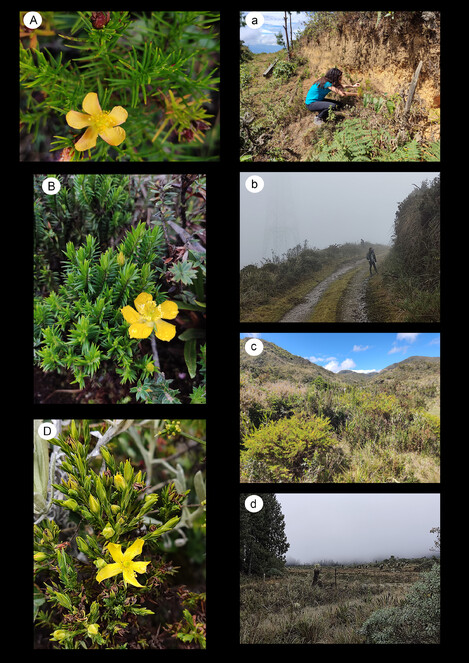
Representative Ecuadorian Hypericum species (capital letters) mentioned in this work and their habitats (small letters). Hypericum acostanum: A & a, Loja, Celica-Guachanamá road. Hypericum matangense: B & b Morona-Santiago, Páramo de Matanga. Hypericum prietoi: c Azuay, Oña-Morasloma road. Hypericum sprucei: D & d Carchi, Reserva Ecológica El Ángel.
This species is listed as vulnerable (VU) in the Ecuadorian Red List. It is known from only two localities, collected in the 50s and 80s in the province of Loja, on the road between San Pedro and Portovelo and on the road between Celica-Guachanamá, respectively. We confirm its persistence in the second locality and provide an exact location with coordinates. In addition, after studying the QCNE herbarium material, we have re-assigned a specimen (voucher nº 5612) from the rovince of Loja to this species. Therefore, we have added a new locality to the distribution of H. acostanum in this rovince.
Hypericum matangense
-
scientificName: Hypericum matangense N. Robson; country:Ecuador; stateProvince:Morona-Santiago; locality:Páramo de Matanga; verbatimLocality:carretera Sígsig-Gualaquiza; verbatimElevation:3366 m; locationRemarks:Morona-Santiago. Páramo de Matanga, carretera Sígsig-Gualaquiza,; georeferenceProtocol:
03°11.5409'S 078°47.3068'W -3,1924 -78,7885 , 3366 m, Páramo con matorralGPS; eventDate:Jul-31-2022; catalogNumber:29ECU-IMI22 (HUTI, MA); recordNumber:29; recordedBy:I. Masa Iranzo, P. Jiménez Mejías, A. Morales Alonso & E. Sánchez; identifiedBy:I. Masa-Iranzo; dateIdentified:2022; basisOfRecord:PreservedSpecimen; occurrenceID:29ECU-IMI22 (HUTI, MA)
Taxon discussion
Hypericum matangense (Fig.
This species is listed as vulnerable (VU) in the Ecuadorian Red List. It is known onlyfrom the type specimen collected in 1980 in the province of Morona-Santiago. The size and status of this population, and its specific threats, are unknown. Our observation is the second known collection of this species, with coordinates from the only specimen found.
Hypericum prietoi
-
scientificName: Hypericum prietoi N. Robson; country:Ecuador; stateProvince:Azuay; verbatimLocality:Carretera Oña-Morasloma; verbatimElevation:2822 m; locationRemarks:Azuay. Carretera Oña-Morasloma,; georeferenceProtocol:
03 26.6385´S 079° 04.5871´W , 2822 m, matorral-pastizalGPS; eventDate:Jul-29-2022; catalogNumber:17ECU-IMI22 (HUTI, MA); recordNumber:17; recordedBy:I. Masa Iranzo, P. Jiménez Mejías, A. Morales Alonso & E. Sánchez; identifiedBy:I. Masa-Iranzo; dateIdentified:2022; basisOfRecord:PreservedSpecimen; occurrenceID:17ECU-IMI22 (HUTI, MA)
Taxon discussion
Hypericum prietoi (Fig.
This species is listed as endangered (EN) in the Ecuadorian Red List. Threats associated with its conservation status include overgrazing and burning. Hypericum prietoi has only been collected once at the type locality, in 1945. Our observation is the second known collection of the species. We provide the coordinates of the only specimen found.
Hypericum sprucei
-
scientificName: Hypericum sprucei N. Robson; country:Ecuador; stateProvince:Bolívar; verbatimLocality:Carretera Chimbo a Totoras; verbatimElevation:3250 m; locationRemarks:Bolívar. Carretera Chimbo a Totoras, 3250 m; georeferenceProtocol:label; eventDate:Feb-21-1987; catalogNumber:QCA 50283; recordNumber:212; recordedBy:X. Buitrón; basisOfRecord:PreservedSpecimen; occurrenceID:QCA 50283
Taxon discussion
Hypericum sprucei (Fig.
Here, we present an additional record for a new province (Bolívar). This species is not included in the Ecuadorian Red List.
Discussion
General considerations about Ecuadorian Carex
Our work reveals a number of common problems in the knowledge of Carex in South America in general and in Ecuador in particular. Although Ecuador is one of the countries in tropical America with the most developed description of its flora, it is not free from the lack of taxonomic understanding of such a difficult group of plants as sedges.
On the one hand, despite the abundant collections in the Páramos promoted by the Ecuadorian government through research projects and vegetation inventories, the relative amount of sedges in the two main national herbaria (QCA, QCNE) is still low. Our field studies have shown that Carex can be among the most abundant plants in páramos, which highlights their ecological importance. However, only a few of the largest species from sect. Fecundae (i.e. C. jamesonii Boott, C. lemanniana Boott and C. pichinchensis Kunth) and Uncinia (C. phleoides Cav.) have been abundantly collected and are available in the QCA and QCNE collections. In particular, we found a large number of populations of C. phalaroides scattered throughout the cordillera, but only a handful of specimens in the herbaria we visited. Another example, and perhaps the most surprising for us, is the discovery of C. punicola for the first time in Ecuador. This species has been completely overlooked to date despite the fact that it can be a dominant part of the vegetation. In fact, in the population collected in the province of Pichincha, the plant was an abundant element of the sparse vegetation, extending over the lower part of the Ovejería puna and even occurring on such accessible places as the road shoulders of one of the main roads in Cotopaxi National Park. This neglect of Carex diversity is probably due to the combined effect of the small size of some of the species involved and the low interest of most naturalists in graminoids.
On the other hand, some species, such as C. collumanthus or C. via-incaica, were relatively well-represented in the herbaria studied despite their small size. This suggests that such species were probably abundant enough in a number of locations to have been overlooked during field collections. However, most of these specimens were missidentified or simply stored as indeterminate. This illustrates the problem of the lack of a comprehensive treatment for Carex in South America in general, and in Ecuador in particular. The lack of an accurate taxonomic treatment is probably what has prevented the formal description of C. via-incaica by other botanists before 2016, as there were already a number of vouchers in QCA or QCNE.
In conclussion, a greater effort in terms of taxonomic and systematic resources is needed before an accurate knowledge of the genus Carex can be achieved. As a result from this work, future changes in the number of native and endemic Carex species reported for Ecuador can be expected as progress is made towards a complete national checklist. This is of paramount importance since species of this genus, as already mentioned, can be abundant, or even dominant, elements of the páramo flora, and thus play a critical role in the ecological functioning of the habitats in which they thrive.
General considerations about Ecuadorian Hypericum
Two species of Hypericum in Ecuador, H. matangense and H. prietoi, were described in 1990 and 1987, respectively and are only known from their type locality. No other records or additional collections are known to us since then. Our expedition seems to be the first discoverty of these species again. During our field campaign and despite our efforts to find other populations, we only found these two species again in their type localities. Apparently, both species have extremely small populations: we found only one specimen of each species. The distribution of these species should be carefully assessed. Similarly, H. acostanum has only been found in three localities since 1987 and we found it in low abundance in one of them.
Hypericum matangense and H. acostanum were listed as VU in the Ecuadorian Red List, while H. prietoi was listed as EN. Our observations suggest that these species may be critically endangered. If this is confirmed, the Red List status of H. matangense and H. prietoi will need to be updated and urgent conservation plans including in situ and ex situ measurements, will need to be implemented.
Acknowledgements
We would like to thank the Government of Ecuador for granting permission to collect field samples (Contrato Marco N° MAATE-DBI-CM-2022-0242). The Servicio Nacional de Áreas Protegidas del Ecuador (SNAP) for their assistance during the visits to protected areas, especially Patricio Oña, who kindly accompanied us during our field surveys in the Pululahua Reserve. The curators and staff of K, QCA and QCNE for assistance in studying their collections and/or for providing material on loan. This research was supported by projects PID2020-113897GB-I00 (DANZ, to P.J.-M. and S.M.-B.) and PID2020-120145GA-I00 (NEODIV, to A.S.-M.) funded by MCIN/AEI/ 10.13039/501100011033 and by the European Union. A research grant for visiting Kew Gardens from the Bentham-Moxon fund to P.J.-M. A.S.-M. and I.M.-I were also supported by the Atracción de Talento CAM program (2019-T1/AMB-12648).
References
- An evolutionary study of Carex subg. Psyllophorae (Cyperaceae) sheds light on a strikingly disjunct distribution in the Southern Hemisphere, with emphasis on Its Patagonian diversification.Frontiers in Plant Science12https://doi.org/10.3389/fpls.2021.735302
- Geographical vs. ecological diversification patterns in Carex section Phacocystis (Cyperaceae): patterns hidden behind a twisted taxonomy.Journal of Systematics and Evolution59https://doi.org/10.1111/jse.12731
- Beiträge zur Kenntniss der Cyperaceen 1. Cyperaceae novae.1.Varel a. d. Jade (Germany) Breitschädel & Vogt
- About this volume: the monograph of Hypericum by Norman Robson.Phytotaxa4(14):1‑4. https://doi.org/10.11646/phytotaxa.4.1.1
- Carex L. In:Flora Mesoamericana.Vol. 6, Alismataceae a Cyperaceae.Universidad Nacional Autónoma de México,México City,464-473pp.
- Biogeography and systematics of Carex subgenus Uncinia (Cyperaceae): A unique radiation for the genus Carex in the Southern Hemisphere.Taxon71:587‑607. https://doi.org/10.1002/tax.12678
- Making Carex monophyletic (Cyperaceae, tribe Cariceae): a new broader circumscription.Botanical Journal of the Linnean Society179(1):1‑42. https://doi.org/10.1111/boj.12298
- World Checklist of Cyperaceae.Royal Botanic Gardens,Kew. URL: http://www.plantsoftheworldonline.org/
- Manual of the genus Carex in Mexico and Central America.US Department of Agriculture,219pp.
- Notes on South American Carex section Schiedeanae and description of the new species Carex roalsoniana.Phytotaxa260:185‑192. https://doi.org/10.11646/phytotaxa.260.2.8
- Two new species of Carex (Cyperaceae) from northern South America.Phytotaxa266(1):21‑26. https://doi.org/10.11646/phytotaxa.266.1.3
- Clarification of the use of the terms Perigynium and Utricle in Carex L. (Cyperaceae).Systematic Botany41(3):519‑528. https://doi.org/10.1600/036364416X692488
- Additional notes on South American Carex sect. Schiedeanae (Cyperaceae) and description of the new species Carex pachamamae.Phytotaxa340(1):55‑62. https://doi.org/10.11646/phytotaxa.340.1.3
- Carex (Cyperaceae) in South America: diversity, phylogenetics and biogeography of a Boreotemperate element in the Neotropics.International Conference on Comparative Biology of Monocotyledons. Monocots VI 25.https://doi.org/10.13140/RG.2.2.15139.30248
- Chorological, nomenclatural and taxonomic notes on Carex (Cyperaceae) from Bolivia and northern Argentina.Kew Bulletin75(24). https://doi.org/10.1007/S12225-020-9880-8
- A new remarkable dwarf sedge (Carex phylloscirpoides, Cyperaceae) from Northern Chile, with insights on the evolution of austral Carex section Racemosae.Systematic Botany46:34‑47. https://doi.org/10.1600/036364421X16128061189567
- A synopsis of the androgynous species of Carex subgenus Vignea (Cyperaceae) in South America.Botanical Journal of the Linnean Society196:188‑220. https://doi.org/10.1093/botlinnean/boaa100
- Cariceae. In Aloysius Sodiro, S. J.: Plantae ecuadorenses. III.Botanische Jahrbücher für Systematik, Pflanzengeschichte und Pflanzengeographie34(4, Beibl. 78):6‑9.
- Libro Rojo de las Plantas Endémicas del Ecuador.Herbario QCA, Pontificia Universidad Católica del Ecuador,Quito.
- Bayesian inference of phylogeny, morphology and range evolution reveals a complex evolutionary history in St. John’s wort (Hypericum).Molecular Phylogenetics and Evolution67(2):379‑403. https://doi.org/10.1016/j.ympev.2013.02.007
- Explosive radiation in high Andean Hypericum rates of diversification among New World lineages.Frontiers in Genetics4(175). https://doi.org/10.3389/fgene.2013.00175
- A clarification of the name Carex hypsipedos C.B.Clarke (Cyperaceae) and a new name for the South American Carex section Acrocystis taxon.Phytotaxa291(4):287‑293. https://doi.org/10.11646/phytotaxa.291.4.6
- A framework infrageneric classification of Carex (Cyperaceae) and its organizing principles.Journal of Systematics and Evolution59(4):726‑762. https://doi.org/10.1111/jse.12722
- Studies in the genus Hypericum L. (Guttiferae) 1, Infrageneric Classification.Bulletin of the British Museum (Natural History) Botany5:291‑355.
- Studies in the genus Hypericum L. (Guttiferae) 2, Characters of the Genus.Bulletin of the British Museum (Natural History) Botany8:55‑226.
- Studies in the genus Hypericum L. (Guttiferae). 3. Sections 1. Campylosporus to 6a. Umbraculoides.Bulletin of the British Museum (Natural History) Botany12:163‑325.
- Studies in the genus Hypericum L. (Guttiferae). 7. Section 29. Brathys (Part 1).Bulletin of the British Museum (Natural History) Botany16:1‑106.
- Studies in the genus Hypericum L. (Guttiferae) 8. Sections 29. Brathys (part 2) and 30. Trigynobrathys.Bulletin of the British Museum (Natural History) Botany20:1‑151.
- Studies in the genus Hypericum L. (Guttiferae). 6. Sections 20. Myriandra to 28. Elodes.Bulletin of the British Museum (Natural History) Botany26:75‑217.
- Studies in the genus Hypericum L. (Guttiferae) 4(1). Sections 7. Roscyna to 9. Hypericum sensu lato (part 1).Bulletin of the British Museum (Natural History) Botany31:37‑88.
- Studies in the genus Hypericum L. (Guttiferae) 4(2). Section 9. Hypericum sensu lato (part 2): subsection 1. Hypericum series 1. Hypericum.Bulletin of the British Museum (Natural History) Botany32:61‑123. https://doi.org/10.1017/S096804460200004X
- Studies in the genus Hypericum L. (Clusiaceae). Section 9. Hypericum sensu lato (part 3): Subsection 1. Hypericum series 2. Senanensia, subsection 2. Erecta and section 9b. Graveolentia.Systematics and Biodiversity4(1):19‑98. https://doi.org/10.1017/S1477200005001842
- Studies in the genus Hypericum L. (Hypericaceae). 5(1). Sections 10. Olympia to 15/16. Crossophyllum.Phytotaxa4(1):5‑126. https://doi.org/10.11646/phytotaxa.4.1.2
- Studies in the genus Hypericum L. (Hypericaceae). 5(2). Sections 17. Hirtella to 19. Coridium.Phytotaxa4(2):127‑258. https://doi.org/10.11646/phytotaxa.4.1.3
- Studies in the genus Hypericum L. (Hypericaceae). 9. Addenda, corrigenda, keys, lists and general discussion.Phytotaxa72(1):1‑111. https://doi.org/10.11646/phytotaxa.72.1.1
- Contributions to a Flora of Venezuela. From Musci through Sarraceniaceae.Fieldiana28:1‑242. URL: https://www.biodiversitylibrary.org/part/172069
- Index Herbariorum.(Updated continously). URL: http://sweetgum.nybg.org/science/ih/
- A first report for Carex hypsipedos (Cyperaceae) in Argentina and Bolivia and the status of C. phalaroides var. parvula in southern South America.Rhodora90(862):149‑155. URL: http://www.jstor.org/stable/23312412
- Notes on Carex azuayae and C. enneastachya (Cyperaceae) from South America.Rhodora100(903):293‑297. URL: http://www.jstor.org/stable/23313366
- A new species of Carex section Abditispicae (Cyperaceae) from South America and additional notes on the section.Darwiniana40(1/4):191‑198. URL: http://www.jstor.org/stable/23225173